Woolton Hill
| Woolton Hill | |
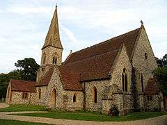
 St Thomas Church (Woolton Hill Church) |
|
 Woolton Hill |
|
| OS grid reference | SU433615 |
|---|---|
| Civil parish | East Woodhay |
| District | Basingstoke and Deane |
| Shire county | Hampshire |
| Region | South East |
| Country | England |
| Sovereign state | United Kingdom |
| Post town | NEWBURY |
| Postcode district | RG20 |
| Dialling code | 01635 |
| Police | Hampshire |
| Fire | Hampshire |
| Ambulance | South Central |
| EU Parliament | South East England |
| UK Parliament | North West Hampshire |
| Website | East Woodhay parish council |
Coordinates: 51°21′15″N 1°22′57″W / 51.3542°N 1.3826°W


Woolton Hill is a village in Hampshire, England, within the civil parish of East Woodhay.[1] The village is situated approximately 6 miles (9.7 km) south-west of Newbury and encompasses the smaller hamlet of Broad Layings within its Northern borders. It has a church, church (village) hall, sports club, youth football club, post office, nursery, infants and junior schools and a pub (The Rampant Cat).
History
An area of farmland, woodland and scattered houses until the mid-eighteenth century, when the new church was built (as a 'daughter church' to the much older ecclesiastical parish of East Woodhay). The village grew rapidly during and since the 1950s and is now much larger (in population terms) than the neighbouring and contiguous village of Highclere. Due to the village's proximity to the A34 road it was the scene of many demonstrations during "the third battle of Newbury" when the Newbury bypass was being built in the 1990s.
Transport
Woolton Hill is served by Stagecoach bus services 21 and 22 from Newbury.[2] Woodhay railway station used to serve the village on the Didcot, Newbury and Southampton Railway until its closure in the 1960s. The disused railway line became, in part, the route for the A34 Newbury Bypass.
Governance
The village of Woolton Hill is part of the civil parish of East Woodhay[3] and is part of the East Woodhay ward of Basingstoke and Deane borough council.[4] The borough council is a Non-metropolitan district of Hampshire County Council.
Geography
To the east/north-east of the village is an area of woodland known as "The Chase" which is managed by The National Trust. The Chase was significantly altered in 2010-2011, to achieve the following goals (1) Return it back into a nature reserve as per its original gift terms (2) to remove parts of the woodlands for successful woodland management. A local water course runs through The Chase and has been dammed to form a small lake in the North Eastern end and it now contains an asphalted car-park. The chase is bounded by the A34 (Newbury bypass) to the North East.
Nearby villages include Ball Hill, Penwood, Highclere, Wash Water and East Woodhay as well as the town of Newbury.
Landmarks
Gainsborough Stud - owned by Mohammed bin Rashid Al Maktoum (Ruler of Dubai) is located in Woolton Hill. The stud land covers a large area in the village.
References
- ↑ "Area: East Woodhay CP (Parish)". Neighbourhood Statistics. Office for National Statistics. Retrieved 2009-11-10.
- ↑ http://www.stagecoachbus.com/PdfUploads/Timetable_19981_23%20&%2024%20%28Newbury%20-%20Burghclere%20via%20Ecchinswell%29.pdf
- ↑ "Hampshire County Council’s legal record of public rights of way in Hampshire" (PDF). 2008. Retrieved 30 October 2010.
- ↑ "Basingstoke and Deane Wards info". 2010. Retrieved 30 October 2010.
External links
![]() Media related to Woolton Hill at Wikimedia Commons
Media related to Woolton Hill at Wikimedia Commons
