Wittstock
| Wittstock | ||
|---|---|---|
|
Town centre | ||
| ||
 Wittstock | ||
Location of Wittstock within Ostprignitz-Ruppin district 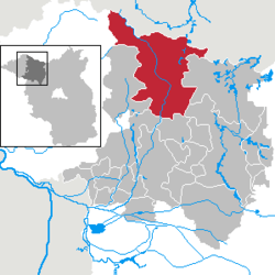 | ||
| Coordinates: 53°9′49″N 12°29′8″E / 53.16361°N 12.48556°ECoordinates: 53°9′49″N 12°29′8″E / 53.16361°N 12.48556°E | ||
| Country | Germany | |
| State | Brandenburg | |
| District | Ostprignitz-Ruppin | |
| Government | ||
| • Mayor | Jörg Gehrmann (CDU) | |
| Area | ||
| • Total | 417.20 km2 (161.08 sq mi) | |
| Population (2013-12-31)[1] | ||
| • Total | 14,631 | |
| • Density | 35/km2 (91/sq mi) | |
| Time zone | CET/CEST (UTC+1/+2) | |
| Postal codes | 16909 | |
| Dialling codes | 03394 | |
| Vehicle registration | OPR, KY, NP, WK | |
| Website | www.wittstock.de | |
Wittstock/Dosse is a town in the Ostprignitz-Ruppin district, in north-western Brandenburg, Germany.
Geography
It is located in the eastern Prignitz region on the Dosse River near the confluence with its Glinze tributary, about 20 kilometres (12 mi) east of Pritzwalk and 95 kilometres (59 mi) northwest of Berlin. Wittstock is situated in a terminal moraine landscape south of the Mecklenburg Lake District.
Town structure
After the incorporation of several suburban villages in December 1993 and again in October 2003, Wittstock became the 6th largest town in Germany by area. However, the former independent districts Herzsprung and Königsberg, which were forced to be integrated in 2003, regained their independence in 2004, claiming that the compulsive integration was void because of a clerical error. Both districts were still under the overview of the department of Wittstock. Since 2005, Herzsprung and Königsberg are parts of the commune Heiligengrabe, so the size of the town decreased.
The current districts of Wittstock/Dosse:
|
|
Demography
-
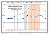
Development of Population since 1875 within the Current Boundaries (Blue Line: Population; Dotted Line: Comparison to Population Development of Brandenburg state; Grey Background: Time of Nazi rule; Red Background: Time of Communist rule)
-
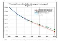
Recent Population Development (Blue Line) and Forecasts
|
|
|
|
History
Wittstock resulted from a Slavic settlement and was first mentioned in the deed of formation for the Bishopric of Havelberg in 946. The name is possibly derived from vysoka ("high-lying") in the language of the local Polabian tribes, it was later Germanized into Wiztok (1271), Witzstock (1284) and Witstock (1441), adapted folk-etymologically to Low German witt ("white") and stock ("rootstock").
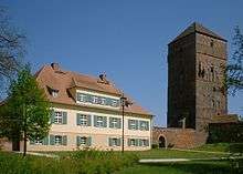
Obtaining the Stendal town charter on 13 September 1248 from the hands of the Havelberg Prince-bishop Henry I, it is one of the oldest towns of Brandenburg. In 1251, Wittstock received an imprint of the town seal, which was one of the oldest in Brandenburg, too. Wittstock Castle, which had been built from 1244 onwards onto a Slavic foundation, served as the residence of the Havelberg Prince-bishops from 1271; it is therefore also designated Old Bishop Castle (Alte Bischofsburg). The Havelberg eraa ended with the Protestant Reformation and the death of the last Catholic Prince-bishop Busso von Alvensleben at Wittstock Castle in 1548.
Up to the Thirty Years' War, the fortress was a secure stronghold—until it became the site of the 1636 Battle of Wittstock, when the troops of the Swedish Empire under Field Marshals Johan Banér and Alexander Leslie defeated the allied Imperial and Saxon forces under Elector John George I of Saxony. Followed by the outbreak of a plague epidemic two years later, Wittstock remained devastated and lost about the half of its population.
The redevelopment of the town was launched by the "Great Elector" Frederick William in 1658. About 1750, numerous colonists descending from Württemberg and the Palatinate settled the region.
Politics

Seats in the town's assembly (Stadtverordnetenversammlung) as of 2008 local elections:
- Social Democratic Party of Germany (SPD): 7
- Christian Democratic Union: 7
- The Left: 6
- Free Voters Prignitz-Ruppin: 4
- Free Democratic Party: 2
- Farmers' association voting bloc: 2
Twin town
Wittstock is twinned with:
 Höganäs in Sweden (since 2004)
Sights
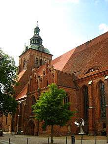
The town's main historic monument is the Brick Gothic St Mary's Church, dating back to c. 1240. Significantly enlarged as a hall church in the late 13th century and repleted with a carved altar by Claus Berg, it was used as a cathedral by the Havelberg bishops.
The Bishop's Castle was greatly restored in the 1990s and today houses a Thirty Years' War museum. Much of the elaborate late medieval defences still surround the old centre, including a 13th-century gate tower, the Daberburg bergfried north of the town, and a 2,500 metres (8,200 ft) long city wall. The wall's height, originally 11 metres (36 ft), today is about 4 to 7 metres.
References
- ↑ "Bevölkerung im Land Brandenburg nach amtsfreien Gemeinden, Ämtern und Gemeinden 31. Dezember 2013 (Fortgeschriebene amtliche Einwohnerzahlen auf Grundlage des Zensus 2011)". Amt für Statistik Berlin-Brandenburg (in German). 2014.
- ↑ Detailed data sources are to be found in the Wikimedia Commons.Population Projection Brandenburg at Wikimedia Commons
External links
| ||||||||
|

