Indian Arm


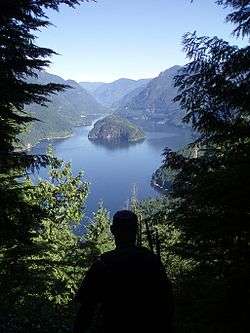
Indian Arm is a steep-sided glacial fjord adjacent to the city of Vancouver in southwestern British Columbia. Formed during the last Ice Age, it extends due north from Burrard Inlet, between the communities of Belcarra (to the east) and the District of North Vancouver (to the west), then on into mountainous wilderness. Burrard Inlet and the opening of Indian Arm was mapped by Captain George Vancouver and fully explored days later by Dionisio Alcalá Galiano in June 1792.[1][2]
Geography

Indian Arm is a salt-water fjord that extends about 20 km (12 mi) north from Burrard Inlet. There are no crossings, and road access is limited to the communities on the southern portion of the arm. The steep mountain slopes are so impassable that most have seen no development, despite the proximity to a major city. Indian River, marked by a small dock at the north end of the arm, can be reached by boat from the Vancouver area or by a logging road from Squamish.
Scenery and attractions
The slopes along Indian Arm are either heavily forested or sheer granite cliffs. The inlet is narrow and the mountains rise steeply on both sides directly from the sea.
There are several waterfalls, with the largest being Granite Falls at the north end on the east side. Spray of Pearls Falls at Wigwam Creek is in the north west corner, and Silver Falls is on the western side at Elsay Creek. There are also numerous unnamed seasonal waterfalls running over the rocky cliff walls that can best be viewed during spring run off. In winter, frozen ice-falls can be viewed.
Wildlife viewing can include seals, bald eagles, herons, and black bears. A large pink salmon run in odd-numbered years starts in July and continues to October; salmon and bear viewing opportunities concentrate at the Indian River estuary in the northwest corner of the inlet.
Recreation and Parks
Indian Arm Provincial Park includes large parts of both shores of the fjord, as well as Racoon and Twin Islands. This park is 6,826 hectares in total. There are wilderness campgrounds at sea level at Bishop Creek (west side), Granite Falls, and Twin Islands. The Park is popular with boaters and kayakers, and is also visited by charter boat day tours leaving from Granville Island, Port Moody, or Coal Harbour. Divers can visit the shallow water surrounding Racoon and Twin Islands.
A rough wilderness hiking trail around the perimeter of Indian Arm was completed in 2003. It was created over many years by engineer and trailbuilder Don McPherson; he also created the Grouse Grind hiking trail up the side of Grouse Mountain.[3]
The south-eastern part of the Indian Arm park is adjacent to and partly surrounds the BC Hydro Buntzen Lake Recreation Area. Belcarra Park is managed by Metro Vancouver; this park surrounds Bedwell Bay on the mid-western side of Indian Arm, and includes the area around Sasamat Lake. The Baden-Powell Trail is challenging but well-maintained and well-marked. It originates at Panorama Park in Deep Cove, passing along the slopes of the mountains on the western side of Indian Arm to its western terminus in Horseshoe Bay, West Vancouver.
Other parks around the shores of eastern Burrard Inlet and Indian Arm include: Cates Park and Panorama Park in the District of North Vancouver, Barnet Marine Park in Burnaby, Rocky Point Park (which includes a boat launch), Inlet Park and Tidal Park in Port Moody, and Thwaytes Landing Metro Park Reserve.
First Nations Heritage
The Say Nuth Khaw Yum Heritage Park / Indian Arm Provincial Park was created in 1995 as part of the BC Government's Lower Mainland Nature Legacy Program. The Park is located within the core of the Tsleil-Waututh Nation Traditional Territory.
A Management Agreement was signed between the Tsleil-Waututh Nation and the Government of BC in 1998. The Management Board has equal representation from the Tsleil-Waututh Nation and the BC Government to co-manage all aspects of the Park and Heritage Area.[4]
Communities reachable by water
Heading north from Deep Cove one hits Woodlands, which is an established beachfront community. There are associated cabins, beaches and areas as one heads north: Thwaites, Alder Point, Bergs, Crocker Island, Indian River, Bedwell Bay, Belcarra, Anmore, Buntzen Bay, Jug Island, and Whiskey Cove.
Buntzen Generating Station


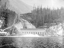
There are two century old powerhouses along the eastern shore of the arm.[5] Water from Coquitlam Lake flows through a 12,775 feet (3,900 m) long tunnel to Buntzen Lake, approximately 150 metres above the tide line in Indian Arm.[6] Boilerplate penstocks direct water from Buntzen Lake down to the two powerhouses on the shores of Indian Arm.
Buntzen No1 was built in 1903 by the Vancouver City Light and Power Company to provide electricity for the Vancouver area's streetcars. It used four 1,500 kW generators and by 1912 three additional 5,000 kW units were installed.[7] The north end of the original four unit powerhouse at Buntzen No1 was demolished in 1950 and a new building, a 55,000 kW unit 1 generator and a larger turbine were added in 1951.[8]
Buntzen No2 was designed by the English architect Francis Rattenbury, it was built in 1912, 1/4 mile south of Buntzen No1 by British Columbia Electric Railway and produced 26,700 kW of power. One of Buntzen No2 three pelton wheels was shut down in 1972 leaving a capacity of 17,800 kW in operation.
Buntzen No1 was shut down during 2010-2011 to complete a turbine runner replacement project.[9] The stations are unmanned, operated by remote control from BC Hydro's System Control facility atop Burnaby Mountain.[10] In 2015 BC Hydro lists capacity of the two powerhouses at 76.8 MW.[11]
Which is Which
There is confusion in maps & photographs around which site is Buntzen No1 and which is Buntzen No2. Buntzen No1 is to the north and has four buildings, with the 1951 generator addition on the north end of the powerhouse and the transformer building uphill. The site is not very appealing except for the ornate granite addition to the south end of the powerhouse with "Vancouver Power" carved in stone. Buntzen No2 is 1,000 feet (300 m) to the south and is all contained within one beautiful building which hasn't changed significantly since 1912.
Wigwam Inn
.jpg)
The Wigwam Inn, located at the north end of Indian Arm, originally opened as a luxury German Biergarten resort and fishing lodge in 1910. A daily steamship route, using the sternwheeler Skeena, brought customers and supplies to the Inn. The property was operated by Count Gustav Constantin Alvo Van Alvensleben during its "glory days" before World War I, and by other operators until 1963. The property was then sold several times, with a somewhat checkered history, including a stint as a gambling casino, which led to a raid by the RCMP. Famous guests over the years included two of the richest men in the world: oil tycoon John D. Rockefeller and the great-grandson of fur-trade millionaire John Jacob Astor.
The Inn is currently owned and operated by the Royal Vancouver Yacht Club as an outstation for club members. There is no public moorage available at the Wigwam docks; reciprocal privileges are not available to members of any other yacht clubs.
References
- BC Parks: Indian Arm Provincial Park, Park facilities, Area guide, and Maps
- Metro Vancouver Regional Park: Belcarra, Directions, Facilities, Area guide, and Maps
- BC Hydro: Buntzen Lake Recreation Area, Directions, Facilities, Area guide, and Maps
- Map of Burrard Inlet and Indian Arm, Village of Belcarra
- Royal Vancouver Yacht Club Wigwam Outstation
- 2002 Aerial Photos of Vancouver, including several views of Burrard Inlet and its shores
- "The Blazer", article on trailbuilder Don McPherson by Charles Montgomery, Western Living magazine, October 2001
- Google Maps and Google Earth maps of the Indian Arm Trail route
Notes
- ↑ Kendrick, John (1990). The Voyage of Sutil and Mexicana, 1792: The last Spanish exploration of the Northwest Coast of America. Spokane, Washington: The Arthur H. Clark Company. p. 133. ISBN 0-87062-203-X.
- ↑ Roberts, John E. (2005). A Discovery Journal: George Vancouver's First Survey Season - 1792. Trafford Publishing. pp. 126–129. ISBN 1-4120-7097-X.
- ↑
- ↑ http://www.twnation.ca/treaty/treaty_SNKY.html
- ↑ Buntzen Lake Recreation Area (BC Hydro web site)
- ↑ http://www.belcarra.ca/reports/The_Buntzen_Lake_Project.pdf
- ↑ https://archive.org/stream/waterpowersofcan00conw/waterpowersofcan00conw_djvu.txt
- ↑ http://www.buntzenlake.ca/history/
- ↑ https://www.bchydro.com/content/dam/hydro/medialib/internet/documents/annual_report/2011_BCH_AnnualReport.pdf
- ↑ http://web.archive.org/web/20080920013555/http://www.bchydro.com/recreation/mainland/mainland1208.html
- ↑ https://www.bchydro.com/energy-in-bc/our_system/generation/our_facilities/lower_mainland.html
Coordinates: 49°22′N 122°53′W / 49.367°N 122.883°W