West Point, Mississippi
| West Point, Mississippi | |
|---|---|
| City | |
| Nickname(s): Point City | |
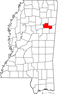
 Location of West Point, Mississippi | |
 West Point, Mississippi Location in the United States | |
| Coordinates: 33°36′22″N 88°39′9″W / 33.60611°N 88.65250°WCoordinates: 33°36′22″N 88°39′9″W / 33.60611°N 88.65250°W | |
| Country | United States |
| State | Mississippi |
| County | Clay |
| Government | |
| • Mayor | Robbie Robinson (mayor) |
| Area | |
| • Total | 21.1 sq mi (54.6 km2) |
| • Land | 20.8 sq mi (53.9 km2) |
| • Water | 0.3 sq mi (0.7 km2) |
| Elevation | 223 ft (68 m) |
| Population (2010)[1] | |
| • Total | 11,307 |
| • Density | 540/sq mi (210/km2) |
| Time zone | Central (CST) (UTC-6) |
| • Summer (DST) | CDT (UTC-5) |
| ZIP code | 39773 |
| Area code(s) | 662 |
| FIPS code | 28-79120 |
| GNIS feature ID | 0679519 |
West Point is a city in Clay County, Mississippi, in the Golden Triangle region of the state. The population was 11,307 at the 2010 census. It is the county seat of Clay County[2] and the principal city of the West Point Micropolitan Statistical Area, which is part of the larger Columbus-West Point Combined Statistical Area.
Geography
West Point is located at 33°36′22″N 88°39′9″W / 33.60611°N 88.65250°W (33.606155, -88.652369).[3]

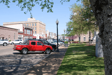
According to the United States Census Bureau, the city has a total area of 21.1 square miles (55 km2), of which 20.8 square miles (54 km2) is land and 0.3 square miles (0.78 km2) (1.28%) is water.
Demographics
| Historical population | |||
|---|---|---|---|
| Census | Pop. | %± | |
| 1870 | 1,392 | — | |
| 1880 | 1,786 | 28.3% | |
| 1890 | 2,762 | 54.6% | |
| 1900 | 3,193 | 15.6% | |
| 1910 | 4,864 | 52.3% | |
| 1920 | 4,400 | −9.5% | |
| 1930 | 4,677 | 6.3% | |
| 1940 | 5,627 | 20.3% | |
| 1950 | 6,432 | 14.3% | |
| 1960 | 8,550 | 32.9% | |
| 1970 | 8,714 | 1.9% | |
| 1980 | 8,811 | 1.1% | |
| 1990 | 8,489 | −3.7% | |
| 2000 | 12,145 | 43.1% | |
| 2010 | 11,307 | −6.9% | |
| Est. 2014 | 11,093 | [4] | −1.9% |

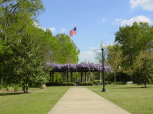



West Point, MS is located in the North East section of Mississippi just across the Alabama state line. West Point has a rich heritage with generations of family lineage calling it home. Historically the area has a blend of African American, White and Native American lineage. The city has many social activities sponsored by church and civic organizations.
As of the census[4] of 2010, there were 11,307 people 4,444 households, and 3,043 families residing in the city. The population density was 535.13 people per square mile (225.3/km²). There were 4,856 housing units at an average density of 235.3 per square mile (90.9/km²). The racial makeup of the city was 40.6% White, 56.9% African American, 0.01% Native American, 0.4% Asian, 0.1% from other races, and 0.2% from two or more races. Hispanic or Latino of any race was 0.9% of the population. There were 3,043 households out of which 22.2% had own children under the age of 18 living with them, 35.1% were married couples living together, 28.4% had a female householder with no husband present, male household no wife present 4.9% and 31.5% were non-families. 28.6% of all households were made up of individuals, and 28.7% had someone living alone who was 65 years of age or older. The average household size was 2.48, and the average family size was 3.04. In the city the population was spread out with 22.6% under the age of 18, 6.4% from 20 to 24, 23.7% from 25 to 44, 25.1% from 45 to 64, and 15.1% who were 65 years of age or older. The median age was 36.4 years. The population was 53.7% female and 46.3% male. The median income for a household in the city was $30,440, and the median income for a family was $39,295. The per capita income for the city was $17,675. About 23.4% of families and 24.6% of the population were below the poverty line, including 37.8% of those under age 18 and 13.6% of those people age 65 or over.
Old Waverly Golf Club, located outside of West Point and recognized as one of Mississippi's top golf courses, hosted the 1999 U.S. Women's Open, which was won by Juli Inkster. West Point Country Club is three minutes from downtown West Point and offers 18 rounds of golf, swimming, tennis and a club house. Payne Field was an advanced Aviation School operated from May 1918 to March 1920. About 1,500 pilots were trained there. It is recognized as the first airfield in the state of Mississippi. Despite averaging less than 1" of snow a year West Point was the home of the original Blazon-Flexible Flyer, Inc. proclaimed to make the very best snow sled in the United States, which became an American tradition. It is called The Flexible Flyer.
Waverly Plantation Mansion, just eight miles east of West Point is a National Historic Landmark. Its four story cantilevered stair hall and cupola is considered unique in the United States. The mansion is open daily for tours from 9am and closes promptly at 5pm. Admission fee charged.
West Point is the home of the Howlin' Wolf Blues Museum. Each Labor Day weekend the town of West Point hosts the Prairie Arts Festival. The weekend kicks off with the Howlin’ Wolf Blues Festival on Friday night followed by the Prairie Arts Festival during the day on Saturday. The festival showcases the areas arts and crafts with shopping, music, rides for children, a 5K race and a car show.
West Point is the home of three high schools: West Point High School, the town's lone public high school, offers a diverse classroom environment and is the largest of the three. Oak Hill Academy and Hebron Christian School are tuition based private schools.
Large businesses in West Point include Southern Ionics, Babcock & Wilcox, and Mossy Oak. Bryan Foods was founded in West Point in 1936 by John H. Bryan, Sr and W.B. Bryan. Bryan Foods was acquired by Sara Lee Corporation in 1968 and continued operations in West Point until March 2007. West Point has an ever increasing economic sector with the opening of the new Prairie Belt Power Site. The Prairie Belt Power Site allows advantage to West Point with its easy access to major highways, waterways and railways; ample electric power and natural gas resources as well as access to three airports.
Notable people
- Jesse Anderson, professional football player.[6]
- Tyrone Bell, professional football player.
- Orlando Bobo, professional football player.[7]
- George Bryan, local businessman, former CEO of Sara Lee Foods.[8]
- John H. Bryan, local businessman and former chairman of Sara Lee Corporation.[9]
- Chester Burnett (1910–1976), better known as "Howlin' Wolf" famous blues musician.
- Bertram Caruthers, educator.[10]
- Jesse Dukeminier (1925–2003), professor of law.
- David Gibbs, legislator, businessman.
- Johnny Green, football player.
- Tom Goode, professional football player[11]
- Toxey Haas, founder and CEO of Haas Outdoors, Inc.
- David Halberstam, journalist and Pulitzer prize recipient.
- Carey Henley, professional football player.[12][13]
- Don Hopkins, pinch runner for the Oakland Athletics of major league baseball.[14]
- Bubba Phillips, baseball player.
- Earl T. Ricks, U.S Air Force Major General, Chief of the National Guard Bureau and Mayor of Hot Springs, Arkansas.
- Brad Smith (born 1968), guitarist for the band Blind Melon.
- Rogers Stevens (born 1970), guitarist for the band Blind Melon.
- Barrett Strong, Motown singer, who had Motown's first hit with "Money".
- Bennie Turner, legislator, lawyer.
Education
Public education in the city of West Point is provided by the West Point School District.
Oak Hill Academy is a private K-12 school.
References
- ↑ "2010 City Population and Housing Occupancy Status". U.S. Census Bureau. Retrieved May 14, 2012.
- ↑ "Find a County". National Association of Counties. Retrieved 2011-06-07.
- ↑ "US Gazetteer files: 2010, 2000, and 1990". United States Census Bureau. 2011-02-12. Retrieved 2011-04-23.
- ↑ "Annual Estimates of the Resident Population for Incorporated Places: April 1, 2010 to July 1, 2014". Retrieved June 4, 2015.
- ↑ "Census of Population and Housing". Census.gov. Retrieved June 4, 2015.
- ↑ "Jesse Anderson".
- ↑ "Orlando Bobo". Retrieved 4 February 2014.
- ↑ "George W. Bryan". Soylent Communications. Retrieved February 2014.
- ↑ "John H. Bryan". Retrieved 4 February 2014.
- ↑ "The History of our Public Schools Wyandotte County, Kansas". Kansas City Kansas Public Schools. December 2, 2002.
- ↑ "Thomas Goode". Retrieved 4 February 2014.
- ↑ "Carey Henley". Retrieved 4 February 2014.
- ↑ "Carey Henley Obituary". Retrieved 4 February 2014.
- ↑ "Crowning the King of the Pinch Runners". Retrieved 4 February 2014.
| |||||||||||||||||||||
