Coney Island – Stillwell Avenue (New York City Subway)
| Coney Island – Stillwell Avenue | |||||||
|---|---|---|---|---|---|---|---|
| New York City Subway rapid transit station | |||||||
|
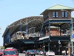
Station building as seen from Surf Avenue | |||||||
| Station statistics | |||||||
| Address |
Stillwell Avenue & Surf Avenue Brooklyn, NY 11224 | ||||||
| Borough | Brooklyn | ||||||
| Locale | Coney Island | ||||||
| Coordinates | 40°34′38.43″N 73°58′52.10″W / 40.5773417°N 73.9811389°WCoordinates: 40°34′38.43″N 73°58′52.10″W / 40.5773417°N 73.9811389°W | ||||||
| Division | B (BMT/IND) | ||||||
| Line |
BMT Brighton Line IND Culver Line BMT Sea Beach Line BMT West End Line | ||||||
| Services |
D F N Q | ||||||
| Transit connections |
| ||||||
| Structure | Elevated | ||||||
| Platforms | 4 island platforms | ||||||
| Tracks | 8 | ||||||
| Other information | |||||||
| Opened |
December 23, 1918 (Sea Beach & West End) May 29, 1919 (Brighton; formal opening) May 1, 1920 (Culver) | ||||||
| Rebuilt | May 23, 2004[1] | ||||||
| Accessible |
| ||||||
| Former/other names | Coney Island Terminal | ||||||
| Traffic | |||||||
| Passengers (2014) |
4,980,140[2] | ||||||
| Rank | 95 out of 421 | ||||||
| Station succession | |||||||
| Next north |
West Eighth Street – New York Aquarium (Brighton/Culver): F 86th Street (Sea Beach local): N 59th Street (Sea Beach express): no regular service Bay 50th Street (West End local): D Bay Parkway (West End express): no regular service | ||||||
| Next south |
(Terminal): D | ||||||
|
| |||||||
| Next |
Kings Highway (via Brighton): Q Church Avenue (via Culver): F Atlantic Avenue – Barclays Center (via Sea Beach): N Bay Parkway (via West End): D | ||||||
| Next |
none: D | ||||||
| |||||||
Coney Island – Stillwell Avenue (also known as Coney Island Terminal) is a New York City Subway station in Coney Island, Brooklyn, acting as the southern terminus for four different services. It is one of the world's largest elevated transportation terminals as well as the most energy-efficient mass transit facility in the United States. This large facility was designed at a time when Coney Island was the primary summer resort area for the New York metropolitan area, with all of the rail lines in southern Brooklyn funneling service to the area.
The station is located at the corner of Stillwell and Surf Avenues in Coney Island, the site of the former West End Terminal; it is the southernmost terminal in the New York City Subway (but not the southernmost terminal in the entire New York City Transit system, which is the Tottenville station of the Staten Island Railway). It has eight tracks and four island platforms, with trains entering from both compass north and south; however, it serves as the railroad-south terminal for all D, F, N and Q trains.
Nearby, tracks from both the BMT West End Line and BMT Sea Beach Line lead into Coney Island Yard.
The terminal is the new home of Transit District 34 of the New York City Police Department.
History
In 1919, a completely reconstructed New West End Terminal was built on an elevated structure to consolidate the terminals of all the former steam railroad lines terminating at Coney Island except the Long Island Rail Road-controlled New York and Manhattan Beach Railway. "West End" was gradually dropped from the terminal's name, and it is now known as Stillwell Avenue Terminal or Coney Island Terminal. Station signage reads Stillwell Avenue – Coney Island.
A City Planning Commission report in 1979 recommended that free bus to subway transfers be implemented for passengers in Coney Island. Free transfers between the B36, B74 bus routes to and from Coney Island – Stillwell Avenue station were proposed. It was noted that the station was the only one in New York City that once had direct rapid transit service in a single zone which didn't get free bus to subway transfers when service was discontinued (in sharp contrast to the BMT Culver Line, BMT Myrtle Avenue Line, and IRT Third Avenue Line, which were discontinued and replaced by bus transfers). The free transfers would stimulate full occupancy in the $200 million worth of government subsidized, recently constructed apartments, and would help integrate Mark Twain Junior High School and attract a stable middle class.[3]
By 1980, the entire system was in a state of disrepair, and the Coney Island Terminal was no exception. It was slated to be rebuilt that year. The Daily News stated that the terminal would emerge "with a bright, new airy look" and would be one of the first stations in the system to benefit from continuously welded rail.[4]
Construction did not start until November 2001, and Coney Island Terminal was entirely reconstructed, with the new terminal opening May 23, 2004 with 6 tracks. The project completed on May 29, 2005, with full restoration of N service and all eight tracks in service. A new entrance building was constructed, with a terra cotta facade in imitation of the former terminal, including restored BMT signs and logos. The former steel and concrete station, badly corroded by the effects of salt water and poor maintenance, was replaced with a new infrastructure, including a soaring roof with arches reminiscent of grand European railway stations such as the Gare Saint-Lazare. The roof is glazed with photovoltaic (solar electric) panels, consisting of 2,800 thin-film modules from Schott AG and covering a surface of 76,000 square feet (7,100 m2). The solar panel system has a nominal power of about 210 kWp, which generates an annual output of 250,000 kW hours, which the station can use to offset power needs. It is the largest renewable-energy enabled mass transit station in the United States. The main terminal and canopy was built by a joint venture between Granite Halmar Construction and Schiavone Construction. The Portal Building was built by Vertex Engineering Services.[5]
In May 2010, the station received new electronic train departure boards for each platform.
Station layout
| 3F | - | Crossover between platforms |
| 2F Platform level |
Track 1 | ← (Temporarily closed for renovation: 86th Street) (No service: 59th Street) |
| Island platform, doors will open on the left, right | ||
| Track 2 | ← (Temporarily closed for renovation: 86th Street) (No service: 59th Street) | |
| Track 3 | → | |
| Island platform, doors will open on the left, right | ||
| Track 4 | → | |
| Track 5 | → | |
| Island platform, doors will open on the left, right | ||
| Track 6 | → | |
| Track 7 | ← (No service: Bay Parkway) | |
| Island platform, doors will open on the left, right | ||
| Track 8 | ← (No service: Bay Parkway) | |
| 1F | Mezzanine | to entrances/exits, station agent, MetroCard vending machines |
| G | Street Level | Entrances/Exits, station house |
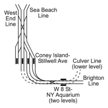
The station has eight tracks and four island platforms, under a roof covered with solar panels. Tracks 1–4 are slightly higher than tracks 5–8 at the station's south end.
Services

| Bay 50th Street (BMT West End Line) | 86th Street (BMT Sea Beach Line) | ||
|---|---|---|---|
| North of the station | |||
| BMT West End Line local D |
BMT Sea Beach Line local N | ||
| In the station | |||
| tracks 7 and 8 D |
tracks 5 and 6 F |
tracks 3 and 4 Q |
tracks 1 and 2 N |
| East of the station | |||
| lower level | upper level | ||
| IND Culver Line local F |
BMT Brighton Line local Q | ||
| West Eighth Street – New York Aquarium (IND Culver Line) |
West Eighth Street – New York Aquarium (BMT Brighton Line) | ||
While labeled a terminal, all of the tracks, with the exception of the West End line tracks, could provide through service in either direction. Only the West End line tracks end at bumper blocks at their south end. The station has been used as a terminal for most of its history, but at least two through services have been offered:
- 7 Brighton–Franklin service, via the BMT Franklin Avenue Line and BMT Brighton Line, through Stillwell Avenue to Manhattan (summer Sundays 1924–1952)
- NX Sea Beach "super-express" service (rush hours 1967–1968)
In 2006, through service was offered during several weekends while track maintenance shut down portions of the BMT Brighton Line north of Kings Highway.
Bus terminal

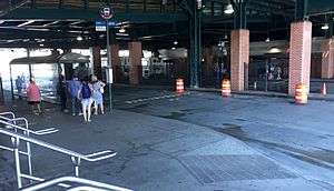
Located underneath the subway station terminal and on Stillwell Avenue and Mermaid Avenue bus terminal, four New York City Bus lines served in this terminal provide easier transfer to the subway and bus connections. One additional bus line is located near the station complex.
| Lane | Route | Terminus |
|---|---|---|
| North side | B68 | Windsor Terrace Bartel Pritchard Square |
| B82 Local and Limited-stops |
Starrett City Pennsylvania Avenue and Seaview Avenue | |
| Station entrance | B74 | Sea Gate West 37th Street and Mermaid Avenue |
| Drop-off only | ||
| Stillwell Avenue and Mermaid Avenue (Western side) |
B64 | Bay Ridge Shore Road and 71st Street |
| Stillwell Avenue and Surf Avenue |
B36 | Westbound: Sea Gate West 37th Street and Surf Avenue |
| Eastbound: Sheepshead Bay Avenue U and Nostrand Avenue | ||
Subway–bus transfer coordination
To reduce missed connections and waiting time between the B36 and B82 bus routes and Q train, New York City Transit began operating yellow holding lights to signal bus operators to wait for imminently arriving trains. The lights, which began operating March 10, 2014, are on the northeast corner of Surf and Stillwell Avenues and in the Mermaid Avenue Bus Loop.[6] The system operates from 11:00 P.M. to 5:00 A.M. daily.
Gallery
-
More detailed view of the main entrance
-

Interior of the station
-

Track 8 platform with the Parachute Jump in the background
-
Main Departure Board
-
.jpg)
Two R160B cars at the station
References
- ↑ Matus, Paul. "The New BMT Coney Island Terminal". The Third Rail Online. Retrieved 2007-08-29.
- ↑ "Facts and Figures: Annual Subway Ridership". Metropolitan Transportation Authority. Retrieved 2015-04-26.
- ↑ The Bulletin, New York Division Electric Railroaders' Association, January 1987, page 5.
- ↑ nycsubway.org—The Diamond Jubilee Brings Optimism
- ↑ Chan, Sewell. "And Now for the Good News From the Subway System". The New York Times. Retrieved 2013-10-16.
- ↑ "Holding the Bus for Trains at Coney Island". Metropolitan Transportation Authority. March 7, 2014.
External links
|
|
| Wikimedia Commons has media related to Coney Island – Stillwell Avenue (New York City Subway). |
- nycsubway.org—Station: Coney Island/Stillwell Avenue
- Station Reporter — D Train
- Station Reporter — F Train
- Station Reporter — N Train
- Station Reporter — Q Train
- The Subway Nut — Coney Island–Stillwell Avenue Pictures
- Brooklyn's New Coney Island Terminal (The Third Rail)
- Franklin–Nassau through service (My Recollection, on the Wayback Machine)
- MTA's Arts For Transit — Coney Island – Stillwell Avenue
- Surf Avenue entrance from Google Maps Street View
- Stillwell Avenue entrance from Google Maps Street View
- Mermaid Avenue entrance from Google Maps Street View
- Platforms from Google Maps Street View
- Historic American Engineering Record (HAER) No. NY-325, "Stillwell Avenue Station, Intersection of Stillwell & Surf Avenues, Brooklyn, Kings County, NY", 53 photos, 40 data pages, 6 photo caption pages
| ||||||||||||||||||||||
| ||||||||||||||||||||||||||||||
