Wendling, Oregon
| Wendling | |
|---|---|
| Unincorporated community | |
|
The historic Wendling Bridge, a covered bridge | |
 Wendling Location within the state of Oregon | |
| Coordinates: 44°11′36″N 122°47′51″W / 44.19333°N 122.79750°WCoordinates: 44°11′36″N 122°47′51″W / 44.19333°N 122.79750°W | |
| Country | United States |
| State | Oregon |
| County | Lane |
| Elevation | 646 ft (197 m) |
| Time zone | Pacific (PST) (UTC-8) |
| • Summer (DST) | PDT (UTC-7) |
| ZIP code | 97454 |
| Area code(s) | 458 and 541 |
| GNIS feature ID | 1136886 |
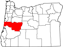
Wendling is an unincorporated community in Lane County, Oregon, United States, located northeast of Marcola.[1] Wendling's post office operated from 1899 to 1952.[2] It was named for George X. Wendling, a local lumberman.[3][4]
A rail line from Coburg, passing through Springfield and Natron, was later extended over Willamette Pass. A branch from Springfield to Wendling was constructed in 1902.[5]
Further reading
- Polley, Louis E. (1984). A history of the Mohawk Valley and early lumbering. Marcola, Oregon: Polley Pub. ISBN 0916930092.
- Velasco, Dorothy (1985). Lane County: An Illustrated History of the Emerald Empire. Windsor Pubns. ISBN 0897811402.
References
- ↑ "Wendling". Geographic Names Information System. United States Geological Survey. November 28, 1980. Retrieved August 17, 2011.
- ↑ "Lane County". Jim Forte Postal History. Retrieved 23 April 2015.
- ↑ McArthur, Lewis A.; McArthur, Lewis L. (2003) [First published 1928]. Oregon Geographic Names (7th ed.). Portland, Oregon: Oregon Historical Society Press. pp. 1020–1021. ISBN 9780875952772. OCLC 53075956.
- ↑ "Names of Lane County Communities Reveal Interesting Histories, Anecdotes". Eugene Register-Guard. 4 January 1942. p. 4. Retrieved 23 April 2015.
- ↑ Leslie M. Scott: History of the narrow gauge railroad in the Willamette Valley. June 1919, Oregon Historical Quarterly.
External links
- "Booth-Kelly Company Ghost Town – Wendling Oregon".
- "The Wendling Project".
- Warner, George. "Growing up in Wendling Oregon".
This article is issued from Wikipedia - version of the Saturday, October 24, 2015. The text is available under the Creative Commons Attribution/Share Alike but additional terms may apply for the media files.

