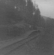
Watergate Halt railway station
| Watergate Halt | |
|---|---|
|
Watergate Halt | |
| Location | |
| Place | Watergate Bridge |
| Area | Torridge |
| Grid reference | SS468176 |
| Operations | |
| Pre-grouping | North Devon and Cornwall Junction Light Railway (1925 to 1948) |
| Post-grouping | Southern Region of British Railways (1948 to 1965)[1] |
| Platforms | One |
| History | |
| 27 July 1925 | Opened |
| 1 March 1965 | Closed |
| Disused railway stations in the United Kingdom | |
|
Closed railway stations in Britain A B C D–F G H–J K–L M–O P–R S T–V W–Z | |
| UK Railways portal | |
Watergate Halt was an intermediate halt on the initially privately run[2] North Devon and Cornwall Junction Light Railway.

Watergate Halt in 1969 looking away from Torrington
"It was one of those moments you always remember – a first glimpse, caught through the dappled sunlight of a woodland glade. Deep within the heart of North Devon, I came across this tiny wayside halt, no longer than a single carriage length."[3]

Watergate Halt in 1969 looking towards Torrington
A remote rural station[4] with one small siding used by a local farmer,[5] it was closed in 1966[6] and now forms part of the popular Tarka trail, a route for ramblers promoted by the local council.[7]
See also
References
- ↑ Private, not grouped in 1923.
- ↑ Became part of Southern Region of British Railways in 1948 Branch Lines to Torrington Mitchell,V/Smith,K: Midhurst, Middleton Press,1994 ISBN 1-873793-37-5
- ↑ Ian Pringle Memories of the Barnstaple to Torrington and Halwill Junction Line (VHS Video-Stock Code: BL267D)
- ↑ Backtrack Vol 19(2005) The North Devon & Cornwall Junction Railway. Walter Rothschild
- ↑ Southern E-group
- ↑ "Discovering Britain's lost railways" Atterbury,P: Basingstoke, AA Publishing ISBN 978-0-7495-6370-7
- ↑ East Devon Council
External links
| Preceding station | Disused railways | Following station | ||
|---|---|---|---|---|
| Torrington | North Devon and Cornwall Junction Light Railway (1925 to 1948) Southern Region of British Railways (1948 to 1965) |
Yarde Halt | ||
| ||||||
Coordinates: 50°56′16″N 4°10′51″W / 50.9377°N 4.1808°W
This article is issued from Wikipedia - version of the Tuesday, July 02, 2013. The text is available under the Creative Commons Attribution/Share Alike but additional terms may apply for the media files.
