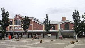
Wakaba Station
Wakaba Station 若葉駅 | |
|---|---|
 West side and forecourt, October 2011 | |
| Location |
4-13-1 Sekima, Sakado, Saitama (坂戸市関間4-13-1) Japan |
| Operated by | Tobu Railway |
| Line(s) | Tobu Tojo Line |
| Connections |
|
| Other information | |
| Station code | TJ-25 |
| History | |
| Opened | 1979 |
| Traffic | |
| Passengers (FY2010) | 36,004 daily |
Wakaba Station (若葉駅 Wakaba-eki) is a railway station on the Tobu Tojo Line in Sakado, Saitama, Japan, operated by the private railway operator Tobu Railway.[1]
Lines
Wakaba Station is served by the Tobu Tojo Line from Ikebukuro in Tokyo. Located between Tsurugashima and Sakado, it is 38.9 km from the Ikebukuro terminus.[2] Rapid, Express, Semi express, Commuter express, and all-stations Local services stop at this station. During the daytime, the station is served by two Rapid and four Express trains per hour in each direction between Ikebukuro and Shinrinkōen or Ogawamachi stations.[3]
Station layout
The station consists of a single island platform serving two tracks. The station building is located above the platforms.
-

East side ground level entrance, October 2011
-

The ticket barriers, October 2011
Platforms

| 1 | ■ Tobu Tojo Line | for Sakado, Shinrinkōen, Ogawamachi, and Yorii |
| 2 | ■ Tobu Tojo Line | for Kawagoe, Wakōshi, and Ikebukuro |
Adjacent stations
| « | Service | » | ||
|---|---|---|---|---|
| Tobu Tojo Line | ||||
| TJ Liner: Does not stop at this station | ||||
| Rapid express: Does not stop at this station | ||||
| Kawagoeshi | Rapid | Sakado | ||
| Tsurugashima | Express | Sakado | ||
| Tsurugashima | Commuter express | Sakado | ||
| Tsurugashima | Semi express | Sakado | ||
| Tsurugashima | Local | Sakado | ||
History
The station opened on 2 April 1979.[2] The name "Wakaba" derived from the nearby Wakabadai housing estate.[4] The station originally had an entrance on the east side only, but was extended in March 2004 with an entrance on the west side leading to a new station forecourt area.
From 17 March 2012, station numbering was introduced on the Tobu Tojo Line, with Wakaba Station becoming "TJ-25".[5]
Passenger statistics
In fiscal 2010, the station was used by an average of 36,004 passengers daily.[6]
Surrounding area

- Kagawa Nutrition University Sakado Campus[4]
- Yamamura International High School
- University of Tsukuba Senior High School at Sakado
- Wakaba Walk Shopping Centre
- Xien Ten Gong, the largest Taoist temple in Japan[7]
- Fujimi Industrial Estate
Bus services
The north side of the station is served by the "Tsuru Wagon" community minibus service operated by the city of Tsurugashima,[8] and by the "Sakacchi Wagon" (Miyoshino Line) community minibus service operated by the city of Sakado.[9]
See also
References
- ↑ "Wakaba Station information" (in Japanese). Japan: Tobu Railway. Retrieved 9 January 2011.
- 1 2 Terada, Hirokazu (July 2002). データブック日本の私鉄 [Databook: Japan's Private Railways]. Japan: Neko Publishing. p. 200. ISBN 4-87366-874-3.
- ↑ Tobu Tojo Line Timetable, published March 2013
- 1 2 Kawashima, Ryozo (February 2011). 日本の鉄道 中部ライン 全線・全駅・全配線 第11巻 埼玉南部・東京多摩北部 [Railways of Japan - Chubu Line - Lines/Stations/Track plans - Vol 11 Southern Saitama and Northern Tama Tokyo]. Japan: Kodansha. p. 64. ISBN 978-4-06-270071-9.
- ↑ 「東武スカイツリーライン」誕生! あわせて駅ナンバリングを導入し、よりわかりやすくご案内します [Tobu Sky Tree Line created! Station numbering to be introduced at same time] (pdf). Tobu News (in Japanese). Tobu Railway. 9 February 2012. Retrieved 21 March 2012.
- ↑ 駅情報(乗降人員) [Station information (Passenger statistics)] (in Japanese). Japan: Tobu Railway. Retrieved 14 December 2011.
- ↑ 地域ニュース: 聖天宮 [Local News: Xien Ten Gong] (in Japanese). Japan: Koedo Net. 3 December 2009. Retrieved 20 July 2011.
- ↑ つるバス・つるワゴンのご案内 [Guide to Tsuru Bus and Tsuru Wagon] (in Japanese). Japan: City of Tsurugashima. 31 October 2013. Retrieved 15 December 2013.
- ↑ さかっちバス・さかっちワゴン時刻表 [Sakacchi Bus & Sakacchi Wagon Timetable] (pdf) (in Japanese). Japan: City of Sakado. 1 November 2013. p. 2. Retrieved 15 December 2013.
External links
| Wikimedia Commons has media related to Wakaba Station. |
- Wakaba Station information (Saitama Prefectural Government) (Japanese)
- Wakaba Station information (Tobu) (Japanese)
Coordinates: 35°56′55″N 139°24′32″E / 35.9487°N 139.4090°E