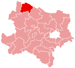
Waidhofen an der Thaya District
| Bezirk Waidhofen an der Thaya | |
|---|---|
| District | |
 | |
| Country | Austria |
| State | Lower Austria |
| Number of municipalities | 15 |
| Area | |
| • Total | 669.1 km2 (258.3 sq mi) |
| Population (2001) | |
| • Total | 28,197 |
| • Density | 42/km2 (110/sq mi) |
| Time zone | CET (UTC+1) |
| • Summer (DST) | CEST (UTC+2) |
Bezirk Waidhofen an der Thaya is a district of the state of Lower Austria in Austria.
Municipalities
Suburbs, hamlets and other subdivisions of a municipality are indicated in small characters.
- Dietmanns
- Alt-Dietmanns, Neu-Dietmanns
- Dobersberg
- Brunn, Dobersberg, Goschenreith am Taxenbache, Großharmanns, Hohenau, Kleinharmanns, Lexnitz, Merkengersch, Reibers, Reinolz, Riegers, Schuppertholz
- Gastern
- Frühwärts, Garolden, Gastern, Immenschlag, Kleinmotten, Kleinzwettl, Ruders, Weißenbach, Wiesmaden
- Groß-Siegharts
- Ellends, Fistritz, Groß-Siegharts, Loibes, Sieghartsles, Waldreichs, Weinern, Wienings
- Karlstein an der Thaya
- Eggersdorf, Göpfritzschlag, Goschenreith, Griesbach, Hohenwarth, Karlstein an der Thaya, Münchreith an der Thaya, Obergrünbach, Schlader, Thuma, Thures, Wertenau
- Kautzen
- Engelbrechts, Groß-Taxen, Kautzen, Kleingerharts, Klein-Taxen, Pleßberg, Reinberg-Dobersberg, Tiefenbach, Triglas
- Ludweis-Aigen
- Aigen, Blumau an der Wild, Diemschlag, Drösiedl, Drösiedl, Kollmitzgraben, Liebenberg, Ludweis, Oedt an der Wild, Pfaffenschlag, Radessen, Radl, Sauggern, Seebs, Tröbings
- Pfaffenschlag bei Waidhofen
- Arnolz, Artolz, Eisenreichs, Großeberharts, Johannessiedlung, Kleingöpfritz, Pfaffenschlag bei Waidhofen a.d.Thaya, Rohrbach, Schwarzenberg
- Raabs an der Thaya
- Alberndorf, Eibenstein, Großau, Koggendorf, Kollmitzdörfl, Liebnitz, Lindau, Luden, Modsiedl, Mostbach, Neuriegers, Niklasberg, Nonndorf, Oberndorf bei Raabs, Oberndorf bei Weikertschlag, Oberpfaffendorf, Pommersdorf, Primmersdorf, Raabs an der Thaya, Rabesreith, Reith, Rossa, Schaditz, Speisendorf, Süßenbach, Trabersdorf, Unterpertholz, Unterpfaffendorf, Weikertschlag an der Thaya, Wetzles, Wilhelmshof, Zabernreith, Zemmendorf, Ziernreith
- Thaya
- Eggmanns, Großgerharts, Jarolden, Niederedlitz, Oberedlitz, Peigarten, Ranzles, Schirnes, Thaya
- Vitis
- Eschenau, Eulenbach, Grafenschlag, Großrupprechts, Heinreichs, Jaudling, Jetzles, Kaltenbach, Kleingloms, Kleinschönau, Schacherdorf, Schoberdorf, Sparbach, Stoies, Vitis, Warnungs
- Waidhofen an der Thaya
- Altwaidhofen, Dimling, Götzles, Hollenbach, Jasnitz, Kleineberharts, Matzles, Puch, Pyhra, Schlagles, Ulrichschlag, Vestenötting, Waidhofen an der Thaya
- Waidhofen an der Thaya-Land
- Brunn, Buchbach, Edelprinz, Götzweis, Griesbach, Kainraths, Nonndorf, Sarning, Vestenpoppen, Wiederfeld, Wohlfahrts
- Waldkirchen an der Thaya
- Fratres, Gilgenberg, Rappolz, Rudolz, Schönfeld, Waldhers, Waldkirchen an der Thaya
- Windigsteig
- Edengans, Grünau, Kleinreichenbach, Kottschallings, Lichtenberg, Markl, Matzlesschlag, Meires, Rafings, Rafingsberg, Waldberg, Willings, Windigsteig
| ||||||||||||
Coordinates: 48°50′38″N 15°17′56″E / 48.844°N 15.299°E
This article is issued from Wikipedia - version of the Saturday, February 23, 2013. The text is available under the Creative Commons Attribution/Share Alike but additional terms may apply for the media files.
