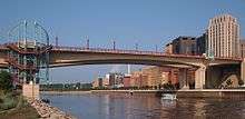
Wabasha Street Bridge
| Wabasha Street Bridge | |
|---|---|
 Northern spans of the Wabasha Street Bridge from Raspberry Island | |
| Coordinates | 44°56′31″N 93°05′28″W / 44.94194°N 93.09111°WCoordinates: 44°56′31″N 93°05′28″W / 44.94194°N 93.09111°W |
| Carries | 4 lanes of Wabasha Street |
| Crosses | Mississippi River |
| Locale | St. Paul, Minnesota |
| Maintained by | City of St. Paul |
| Characteristics | |
| Design | Concrete segmental box girder |
| Total length | 1253 feet (381 m) |
| Width | 104 feet |
| Longest span | 397 feet |
| History | |
| Opened | July 1998 |
The Wabasha Street Bridge is a segmental bridge that spans the Mississippi River in downtown St. Paul, Minnesota, United States. It was named Wabasha Street Freedom Bridge in 2002, to commemorate the first anniversary of the September 11 attacks.[1] It actually consists of two separate bridges, one for northbound and one for southbound traffic. The use of a concrete segmental box girder bridge provided a construction advantage because no falsework needed to be built beneath the bridge.
The bridge opened to traffic in 1998; some decorative elements were not completed until late 2001. It was built by Lunda Construction Company and was designed by Toltz, King, Duvall, Anderson & Associates, Inc.. A large opening ceremony was planned, with bridge closed to traffic and free ice cream. Mayor Norm Coleman let loose two rehabilitated Bald eagles, a male and a female. The planning for the event was largely carried out by the city's marketing department, under the direction of Joe Zappa.
The new bridge replaced an earlier structure that was built in 1889.
The new bridge was built with pedestrians in mind. It features 11-foot-wide sidewalks (3.4 m), six overlooks at the pier locations, and a stairway down to Raspberry Island. The color scheme of the bridge was also planned to reflect the architectural heritage of St. Paul, with a soft buff color (the color of sandstone) to reflect the colors used in many downtown St. Paul buildings. The color of terracotta roofs in the city was used to select the color of the railings, and the green patina of the St. Paul Cathedral is echoed in the ornamental color of the overlooks.
The new bridge has won several awards, including the Federal Highway Administration 1998 Excellence in Highway Design Award and the Minnesota Society of Professional Engineers 2001 Seven Wonders of Engineering in Minnesota award.
The pedestrian walkways are on the outside of the bridge. There is a gap of 8.7 feet (2.7 m) between the two bridge decks, between the southbound bridge and the northbound bridge. In July 2011, a man jumped over the inner railing, on the side not designated for pedestrians, thinking a landing was on the other side. Instead, he fell 55 feet (17 m) and landed on Raspberry Island underneath the bridge. He survived the fall but was critically injured.[2]
To mark the Minnesota Senate's vote to allow same sex marriage in Minnesota, mayor Chris Coleman issued a proclamation on May 13, 2013 temporarily renaming the bridge "Wabasha Street Freedom to Marry Bridge" and ordered dozens of rainbow flags to be flown on the bridge.[1]
1886 Bridge
|
Wabasha Street Bridge | |
.jpg) | |
|
Former Wabasha Street Bridge in 1993 | |
| Location | Wabasha St. over Mississippi River, St. Paul, Minnesota |
|---|---|
| Area | less than one acre |
| Built | 1890 |
| Architect | Multiple |
| Architectural style | Cantilever deck truss |
| MPS | Iron and Steel Bridges in Minnesota MPS |
| NRHP Reference # | 89001834[3] |
| Added to NRHP | 1989 |
The previous bridge was an iron cantilever deck-truss bridge, which was an advanced engineering feat at the time. That bridge was listed in the National Register of Historic Places in 1989. Unfortunately, that bridge had increasing problems with repair and maintenance because of its age, and after city engineers assessed the condition of the old bridge, the decision was made to replace the bridge.
See also
References
- 1 2 "St. Paul dresses in gay pride colors". MPR News. May 13, 2013.
- ↑ Gottfried, Mara (2011-07-29). "Man falls 55 feet from St. Paul bridge, survives". St. Paul Pioneer Press. Retrieved 2011-08-05.
- ↑ Staff (2009-03-13). "National Register Information System". National Register of Historic Places. National Park Service.
External links
-
 Media related to Wabasha Street Bridge (1998) at Wikimedia Commons
 - City of St. Paul, Wabasha Street Bridge. Accessed March 30, 2006.
- Lunda Construction - Wabasha Street Bridge. Accessed March 30, 2006.
- Wabasha Street Bridge at Structurae. Accessed March 30, 2006.
- Wabasha Street Bridge
| |||||||||