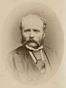
William Tietkens


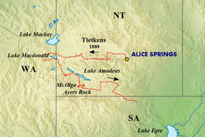
William Henry Tietkens (30 August 1844 – 19 April 1933), known as "Harry Tietkens",[1] explorer and naturalist, was born in England and emigrated to Australia in 1859.[2] Tietkens was second in command to Ernest Giles on expeditions to Central Australia in 1873 and on a journey from Beltana, South Australia to Perth, Western Australia in 1875.[2] In 1889 Tietkens led his own expedition west of Alice Springs to the vicinity of the Western Australian border.[3] This expedition discovered Lake MacDonald, the Kintore Range, Mount Rennie, the Cleland Hills, defined the western borders of Lake Amadeus, and photographed Uluru (Ayers Rock) and Kata Tjuta (Mount Olga) for the first time. The expedition collected new species of plants and rock samples allowed the South Australian government geologist to compile a 'geological sketch' of the country traversed. Tietkens was elected a fellow of the Royal Geographical Society on his return.
Tietkens later worked for the New South Wales Department of Lands as a surveyor from 1891 until his retirement in 1909.[2] He died at Lithgow, New South Wales.
References
- ↑ "Mr. Tietkens's Memories". The Advertiser (Adelaide, SA : 1931 - 1954) (Adelaide, SA: National Library of Australia). 18 April 1932. p. 12. Retrieved 29 October 2014.
- 1 2 3 Hartwig, Mervyn (1976). "Tietkens, William Harry (1844 - 1933)". Australian Dictionary of Biography. Canberra: Australian National University. Retrieved 2008-05-15.
- ↑ Joy, William (1964). The Explorers. Adelaide: Rigby Ltd. p. 72. ISBN 0 85179 112 3.
External links
- William Harry Tietkens, Biography
- Death of Tietkens (Trove: The Argus Melbourne 20 April 1933)
- Tietkens Explorer and Pioneer (Trove:Sydney Morning Herald 27 Dec 1930)
- Letter from David W. Carnegie to Tietkens (at Flinders University Library)
|