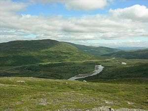
Vildmarksvägen

Vildmarksvägen (English: Wilderness road), sometimes called Stekenjokkvägen by people living in Stekenjokk, which crosses the Vildmarksvägen, is a tourist road stretching from northern Jämtland to southern Lapland, Sweden.[1] It begins in Strömsund and ends in Vilhelmina. Part of the road is closed during winter at times because of heavy snow, which can reach up to 7 metres (23 ft).[2] In 2012 the Frostvikens Fjällpark was open in Gäddede as part of the Vildmarksvägen.[2] Vildmarksvägen also hosts the Bjurälven nature reserve.[2]
Route
The 360 kilometres (220 mi)[3] route of Vildmarksvägen begins in Strömsund.[4] It continues to the town of Gäddede and Road 342, then passes through Jormvattnet, Stora Blåsjön, and Stekenjokk, and on to Klimpfjäll.[3] From there it continues to Kultsjön and Saxnäs via Stalon and Lake Moalgomaj, on to Vilhelmina.[3] Parts of the road through Kalfjället are closed at times during winter because of heavy snow,[5] and the Stekkenjokk plateau is also closed from mid-October to the beginning of June.[3]
Highlights
The Vildmarksvägen crosses a region that has the greatest concentration of bears in Sweden.[2][3]
The area spanned by the road is very scenic and has many rivers and waterfalls. One of the waterfalls, Hällingsåfallet (which also is a nature reserve), drains into the longest water canyon of Northern Europe.[4] With a drop of 43 metres (141 ft),[3] Hällingsåfallet has been called "Sweden's answer to Niagara Falls". Hällingsåfallet's canyon is 800 metres (2,600 ft) long and, due to ongoing soil erosion, its length is still increasing.[3]
Vildmarksvägen passes near Gaustafallet, another waterfall which also drains into a gorge. This waterfall was one of the locations for a film by Astrid Lindgren, titled Ronia the Robber's Daughter.[6] Although the area is similar in size to Västra Götaland County, which has a population of 1,590,000, the population in the wilderness area is only 22,000, resulting in a population density of less than 1 person per km2.[7]
The waterfall of Brakkåfallet is located on the route of Vildmarksvägen between Jorm and Stora Blåsjön.[6] Sweden's longest cave, the Korallgrottan is found between Stora Blåsjön and Ankarvattnet along Vildmarksvägen.[8]
As Vildmarksvägen winds eastward it passes near the Sami village of Fatmomakke, a community built with a church at its centre. The community lives in 80 traditional goahti as well as 20 more modern homes which are constructed radially around the church. Twenty wooden huts are also found on the shore of Kultsjön lake. There is also a visningskåta, model hut, built on an elevation near the church.[3]
Because of its altitude, mosquitoes and gnats do not exist in the region.[9]
References
- ↑ "Vildmarksvägen, ta en praktfull resa genom ofördärvade vildmarker i den Norra svenska fjällvärlden". Wildernessroad.eu. Retrieved 2013-11-28.
- 1 2 3 4 "Discover Jämtland Härjedalen | Vildmarksvägen". Jamtland.se. Retrieved 2013-11-28.
- 1 2 3 4 5 6 7 8 "Vildmarksvägen: the Wilderness Way | Swedish Lapland Guide". Rough Guides. Retrieved 2013-11-28.
- 1 2 Olesen, Elisabet (2006). Adventure Guide to Sweden. Hunter Publishing, Inc. p. 139. ISBN 978-1-58843-552-1.
- ↑ "Ingen risk för avåkning". Västerbottens-Kuriren. 2013-01-18. Retrieved 2013-11-28.
- 1 2 "Hällingsåfallet". Vildmarksvägen.
- ↑ "Galen i Vildmarken?". Vildmarksvägen.
- ↑ "Hällingsåfallet". Vildmarksvägen.
- ↑ "Unika Vildmarksvägen". Klimpfjall.se. Retrieved 2013-11-28.