Versailles, Louisiana
| Versailles | |
| Unincorporated community | |
| Country | United States |
|---|---|
| State | Louisiana |
| Parish | St. Bernard Parish |
| Coordinates | 29°56′54″N 89°57′39″W / 29.94833°N 89.96083°WCoordinates: 29°56′54″N 89°57′39″W / 29.94833°N 89.96083°W |
| Timezone | CST (UTC-6) |
| - summer (DST) | CDT (UTC-5) |
|
Location of Versailles in Louisiana
| |
 Location of Louisiana in the United States
| |
Versailles is an unincorporated community in Saint Bernard Parish, Louisiana. It is along the East Bank of the Mississippi River, about 3.5 miles below the lower limit of New Orleans. The community, for governmental and postal address purposes, is considered part of Chalmette and by some designations, part of neighboring Meraux. The name "Versailles", as a place designation, continues in local use.
History
In 1805, Versailles was founded by Louisiana's wealthiest plantation owner, Major-General Pierre Denis de la Ronde (1762-1824), the commander of the Louisiana militia at the Battle of New Orleans, which was fought at Chalmette on the plantation of his first cousin, Ignace Martin de Lino de Chalmette (1755-1815).
De La Ronde, with other local investors, made plans to lay out Versailles along the Mississippi River and cut a barge canal through some dozen miles of swamp to the shore of Lake Pontchartrain, where he would build another town, called Paris. The communities were named for Paris and Versailles in France. De La Ronde proclaimed that this Versailles would soon overtake New Orleans in size and importance. Such development never happened.
Versailles remained just a small town for the rest of the 19th century, the proposed Paris on the Lakefront never developed, and no navigable canal linked the River and the Lake until the Industrial Canal was built in New Orleans in the 20th century. De La Ronde's road fared better; his path through the swamps developed into a major artery, and Paris Road remains the farthest downriver route connecting the River and the Lake in Greater New Orleans.
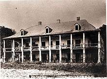
The name Versailles is sometimes mistakenly used to refer to the De La Ronde plantation, the location of what was considered the most stylish plantation home in that part of Louisiana, in its day. There is no evidence, however, that De La Ronde referred to the family's plantation by that name. In 1783, De la Ronde built an avenue of southern live oaks planted to celebrate his 21st birthday.
His home was heavily damaged and looted during the Battle of New Orleans, in 1815. It burned to the ground in 1876. The ruins of the plantation remain visible along Highway 46 in St. Bernard Parish, as does the live oak tree avenue that once graced the path from the Mississippi River landing to the manor house.

| |||||||||||||||||||||
