Vaitape


Vaitape is the largest city of island Bora Bora in French Polynesia. It has a population of 4,927, about half of the island's population which is about 9,000. It is located about 130 mi (210 km) northwest of Papeete, the capital of French Polynesia. The main language of Vaitape is French, although 20 percent of the population speaks Tahitian.
History of Vaitape
The area was first settled by early Polynesians who arrived on canoes during the 4th century. The early Polynesians built grass huts and hunted fish with spears and sticks. The Tahitians lost the French Tahitian War making Tahiti and all the other islands belong to France. During the California Gold Rush, many people left Vaitape in search for gold. By the 1900s the population of the area had grown significantly, and during World War II it served as a military supply base, and it had an oil depot, an airstrip, and a seaplane base.
Weather
The city has a tropical climate since it is in the tropics.
| Climate data for Vaitape | |||||||||||||
|---|---|---|---|---|---|---|---|---|---|---|---|---|---|
| Month | Jan | Feb | Mar | Apr | May | Jun | Jul | Aug | Sep | Oct | Nov | Dec | Year |
| Record high °C (°F) | 30 (86) |
31 (88) |
31 (88) |
31 (88) |
30 (86) |
29 (84) |
29 (84) |
28 (82) |
29 (84) |
29 (84) |
30 (86) |
30 (86) |
31 (88) |
| Daily mean °C (°F) | 27 (81) |
28 (82) |
28 (82) |
28 (82) |
27 (81) |
26 (79) |
26 (79) |
25 (77) |
26 (79) |
26 (79) |
27 (81) |
27 (81) |
26.8 (80.3) |
| Record low °C (°F) | 24 (75) |
24 (75) |
24 (75) |
24 (75) |
24 (75) |
22 (72) |
22 (72) |
22 (72) |
22 (72) |
23 (73) |
24 (75) |
24 (75) |
22 (72) |
| Average rainfall mm (inches) | 262 (10.31) |
232 (9.13) |
205 (8.07) |
162 (6.38) |
133 (5.24) |
96 (3.78) |
84 (3.31) |
68 (2.68) |
72 (2.83) |
112 (4.41) |
228 (8.98) |
276 (10.87) |
1,930 (75.99) |
| Average rainy days (≥ some (undefined)) | 17 | 16 | 18 | 13 | 9 | 6 | 5 | 4 | 5 | 5 | 6 | 12 | 116 |
| Source: World Climate Guide[1] | |||||||||||||
Geography


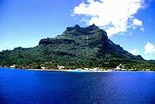
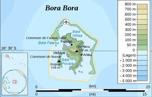
Vaitape is located on the western side of the main island of Bora Bora. It has a view of the western part of the Bora Bora lagoon. It is about 2,000 mi (3,200 km) east of Sydney, Australia. It also has a view of Bora Boras tallest mountain, Mont Otemanu. It is surrounded with islets marking the end of the Bora Bora lagoon. The city is located about 20 ft (6.1 m) above mean sea level. Mount Pahia is another major mountain close to Vaitape.
Transportation
Bora Bora Airport is an airport outside Vaitape on Motu Mute on the northern part of Bora Bora. Small boats leave the mainland and go across the Bora Bora Lagoon. Several ferries leave Bora Bora and sail to Tahiti and Moorea. Some of these ferries are the Aremeti ferry and the Moorea ferry. Uturoa has a few ferries coming into Vaitape.
Air
Bora Bora Airport serves Bora Bora and Vaitape; the boats that sail across the lagoon to reach the islet are colored brown. The airport has many destinations to other islands of French Polynesia. Air Tahiti is the only airline at the airport. If residents want to make an international flight, they would have to take Air Tahiti to Faa'a International Airport, which is located in Faaa, Tahiti, and is the only airport in French Polynesia that serves international flights.
Sea
The ferries of Aremiti and Moorea leave the Vaitape wharf twice a day. The Aremiti ferry sails to both Tahiti and Moorea. The Aremiti ferry is white with red and white stripes. The Moorea ferry is white on the top and blue on the bottom. The Moorea ferry sails to the Vaiare Wharf at Moorea. Sometimes, cruise ships from Papeete leave the wharf and come to Vaitape to stop and pick up more islanders. Some ferries sail to Uturoa on the island of Raiatea. Other small boats go to other of Bora Bora's islets to have tours and walk around.
Road
Bora Bora's main road runs through Vaitape and is the busiest street. There are some other major streets. There are a small street that links the main road to a Bora Bora Pearl shop. The closest freeway to Vaitape is Tahiti's west coast freeway.
Economy
There are some supermarkets located in the city. There are some things like fish, fruit, bread, cereal and French pastries in the supermarket. Some of the fruits are breadfruits, pineapples, and bananas. Some of the fish are salmon. Many fruit are imported from Faaa.
References
- ↑ "Vaitape, Bora Bora Climate Guide". World Climate Guide. Retrieved October 23, 2011.
Coordinates: 16°30′23″S 151°44′58″W / 16.50639°S 151.74944°W