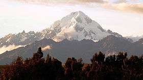
Veronica (mountain)
For the mountain west of the peak of Urupampa, see Waqay Willka.
| Veronica | |
|---|---|
|
Willka Wiqi, Waqra Willk'i Urupampa | |
 | |
| Highest point | |
| Elevation | 5,893 m (19,334 ft) [1] |
| Coordinates | 13°09′51″S 72°19′33″W / 13.16417°S 72.32583°WCoordinates: 13°09′51″S 72°19′33″W / 13.16417°S 72.32583°W |
| Geography | |
 Veronica Peru | |
| Location | Peru, Cusco Region |
| Parent range | Andes, Urupampa |
| Climbing | |
| First ascent | 1- 1956 via N.E. ridge: N. face-1973: S.W. rib-1977: N.E. buttress attempt-1983 (see AAJ, 26 (1984): 208-9)[2] |
Willka Wiqi,[3] ("holy tear")[4] Waqra Willk'i[5] ("horn pass"),[4] Waqay Willk'i, Wayna Willka,[6] Waqay Willka[7] or Urupampa ("spider's plain"),[4][8] (hispanicized names Chamas Grande, Huaccac Huilas, Huacay Huilcay, Huacrahuilki, Huicaivilca, Huajayhuillca, Panticalla, Piri, Urubamba,[9] Willka Weqe, Wequey Willca, Wequey Wilka, Wakaywillque), Spanish names Verónica[10][6] or Padre Eterno, is a 5,893 m (19,334 ft) mountain in the Urupampa mountain range in the Andes of Peru. It is located in the Cusco Region, La Convención Province, Huayopata District, and in the Urubamba Province, Ollantaytambo District[11] northwest of Ollantaytambo.
See also
References
- ↑ Peru 1:100,000, Urubamba 2444, Map prepared and published by the Defense Mapping Agency, Hydrographic/Topographic Center, Bethesda, MD, showing Nevado Urubamba
- ↑ Jill Neate, Mountaineering in the Andes, 1994
- ↑ vidayestilo.terra.com.pe
- 1 2 3 Diccionario Quechua - Español - Quechua, Academía Mayor de la Lengua Quechua, Gobierno Regional Cusco, Cusco 2005 (Quechua-Spanish dictionary)
- ↑ The American Alpine Journal, Vol. 15, No. 2, Issue 47, 1973, p. 389. Nevado Verónica (Padre Eterno or Huacrahuilki)
- 1 2 www.andeshandbook.org Nevado Verónica: Wakaywillque, originalmente llamado Waynawillca
- ↑ John Biggar, Los Andes - Una Guía Para Escaladores, p. 113. Verónica: Es también conocido como Huacay Huilcay, Waqaywillka o Padre Eterno.
- ↑ Teofilo Laime Ajacopa, Diccionario Bilingüe Iskay simipi yuyayk'ancha, La Paz, 2007 (Quechua-Spanish dictionary)
- ↑ "Municipalidad Distrital de Santa Teresa. Historia". munisantateresa.gob.pe. Retrieved November 29, 2015. see: Nevado Urubamba
- ↑ Peru 1:100 000, Urubamba (27-r). IGN (Instituto Geográfico Nacional - Perú).
- ↑ escale.minedu.gob.pe Map of the Urubamba Province
This article is issued from Wikipedia - version of the Monday, December 07, 2015. The text is available under the Creative Commons Attribution/Share Alike but additional terms may apply for the media files.