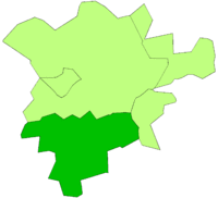
Uppingham Rural District
| Uppingham | |
|---|---|
 | |
| Area | |
| • 1911 | 24,735 acres (100.10 km2) |
| • 1961 | 24,735 acres (100.10 km2) |
| Population | |
| • 1901 | 6,809 |
| • 1971 | 6,587 |
| History | |
| • Origin | Rural sanitary district |
| • Created | 1894 |
| • Abolished | 1974 |
| • Succeeded by | Rutland |
| Status | Rural district |
| Government |
Uppingham Rural District Council |
| • HQ | Uppingham |
| Subdivisions | |
| • Type | Civil parishes |
Uppingham was a rural district in Rutland, England from 1894 to 1974, covering the south-west of the county.
The rural district was formed by the Local Government Act 1894 from the part of the Uppingham rural sanitary district in Rutland. At the same time, the remainder of Uppingham RSD, which lay in Leicestershire and Northamptonshire became Hallaton Rural District and Gretton Rural District respectively.[1]
The only town in the district was Uppingham.
The rural district was abolished in 1974 by the Local Government Act 1972. Oakham RD was merged with three other authorities to become the non-metropolitan district of Rutland.[2]
Parishes
The rural district consisted of twenty civil parishes:[2]
- Ayston
- Barrowden
- Beaumont Chase
- Belton
- Bisbrooke
- Caldecott
- Glaston
- Lyddington
- North Luffenham
- Morcott
- Pilton
- Preston
- Ridlington
- Seaton
- South Luffenham
- Stoke Dry
- Thorpe by Water
- Uppingham
- Wardley
- Wing
References
- ↑ "Uppingham RD". Vision of Britain. Retrieved 2008-06-28.
- 1 2 F A Youngs Jr., Guide to the Local Administrative Units of England, Vol II: Northern England, London, 1991
Coordinates: 52°35′N 0°43′W / 52.59°N 0.72°W