Ulriken
| Ulriken | |
|---|---|
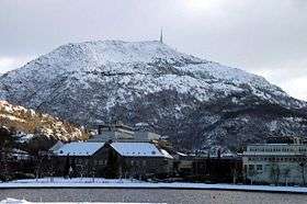
 Ulriken, as seen from the centre of Bergen | |
| Highest point | |
| Elevation | 643 m (2,110 ft) |
| Coordinates | 60°22′38.54″N 5°21′51.72″E / 60.3773722°N 5.3643667°ECoordinates: 60°22′38.54″N 5°21′51.72″E / 60.3773722°N 5.3643667°E |
| Geography | |
| Location | Bergen, Hordaland, Norway |
| Topo map | 1115 I Bergen |
| Climbing | |
| Easiest route | Aerial tramway |


Ulriken is the highest of the Seven Mountains (de syv fjell) that surround Bergen, Norway. It has an altitude of 643 metres above sea level.
Ulriken has an aerial tramway, Ulriksbanen, that can bring people to the top. At the top there is a TV tower, a restaurant, and free telescopes. The cable car was closed as of January 2006, due to the operating company failing to meet government requirements for documentation, but it reopened later in the spring of the same year. It was later closed again, but it reopened for business on May 1, 2009.[1]
An area of the mountain is called "Montana".[2]
The trail
There is a network of trails to climb Ulriken. The no 12 bus from Bergen stops at Montana, from where it is a short walk to the path up Ulriken. It is a popular hike and there are several paths up ranging from steep to not so steep, though a little scrambling is involved. There are signposts along the way. The path is rocky and slippery in wet weather.
References
External links
- Ulriken Opp: Løypen [Ulriken up: the track]