Udon Thani Province
| Udon Thani | ||
|---|---|---|
| Province | ||
| อุดรธานี | ||
| ||
| Motto: กรมหลวงประจักษ์สร้างเมือง ลือเลื่องแหล่งธรรมะ อารยธรรมบ้านเชียงมรดกโลกห้าพันปี ธานีผ้าหมี่ขิด ธรรมชาติเนรมิตทะเลบัวแดง | ||
|
| ||
| Coordinates: 17°25′N 102°45′E / 17.417°N 102.750°ECoordinates: 17°25′N 102°45′E / 17.417°N 102.750°E | ||
| Capital | Udon Thani | |
| Government | ||
| • Governor | Amnat Phakarat | |
| Area | ||
| • Total | 11,730 km2 (4,530 sq mi) | |
| Population (2014) | ||
| • Total | 1,572,300[1] | |
| Human Development Index | ||
| • HDI (2010) | 0.810 (very high) (1st) | |
| Postal code | 41xxx | |
| Calling code | 042 | |
| Vehicle registration | อุดรธานี | |
| Accession into Kingdom of Thailand | 1868 | |
| Accession into Kingdom of Thailand | 1932 | |
| Website | http://www.udonthani.go.th | |
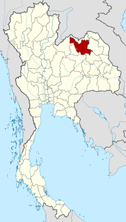
Udon Thani is a province (changwat) in northeast Thailand. It is bordered by the provinces of Nong Khai to the north, Sakon Nakhon to the east, Kalasin Province to the southeast, Khon Kaen to the south, and Loei and Nong Bua Lam Phu Province to the west. It occupies an area of 11,730 km².[2] The provincial capital is Udon Thani, the major city in the province.
Etymology
Udon Thani is said to mean "northern city". "Udon" is derived from "utara" in Sanskrit, meaning "northern direction", as Udon Thani is north of Bangkok. "Thani" means "city". Udon Thani was the capital city of Udon county, the northern region of Thailand.
History
Udon Thani first marked its name in the Bangkok era's history when Anuwong staged an uprising and marched Laotian troops to Nakhon Ratchasima during the period 1826–1828. Met with fierce resistance from the local troops led by Lady Mo, wife of the Nakhon Ratchasima governor. Anuwong was forced to retreat back to Nong Bua Lamphu, a city close to present-day Udon Thani. The Laotians eventually lost a two-day to Siamese troops and the Nong Bua Lamphu militia.[3]
Formerly known as Ban Mak-kaeng, Udon Thani was first settled as a military base established by Prince Prachak to suppress on an uprising in the northeastern state of Lao Puan. Ban Mak-kaeng evolved from a rural town to eventually become what now the major city of Udon Thani.
The province is best known for the prehistoric archeological site at Ban Chiang and its Bronze Age relics, located in what is now a hamlet about 50 kilometres (31 mi) east of Udon. Udon is one of the more bustling markets for agricultural goods in the relatively dry northeast of Thailand, and received its biggest economic boost in the 1960s when the United States built the Udon Royal Thai Air Force Base as a joint-force military base during the Vietnam War. The Mel Gibson film Air America depicts Udon and includes scenes of the Udon air base. Udon Thani was also the largest base in the region for the CIA's anti-communism campaign in Thailand and Laos.
The United States turned the base over to the Royal Thai Air Force in 1976, but its former presence had three significant effects on Udorn. First, a large number of the locals had been paid comparatively well and had learned basic conversational English; this made them more marketable to the outside world, and a significant number of them now work in the Middle East oilfields. Secondly, the base created long-standing ties with the United States, including a US consulate in Udon (closed in 1995), and a US Veterans of Foreign Wars Post. But most importantly, the base and the consulate turned the city into a regional hub for the northeast, and this continues today.
In recent years Udorn received international attention because of the discovery of large potash deposits. Some anticipate the region would become a major exporter of the mineral. However, granting the necessary approvals has been substantially delayed due to large public opposition to mining. Many villagers living near the proposed mine site fear that the mining company's environmental impact assessment (EIA) did not adequately address the problems of salinization of the groundwater and soil, as well as probability of land subsidence. Either of these would seriously threaten the economic stability of local communities that depend on rice farming for their income.
Climate
| Climate data for Udon Thani (1981–2010) | |||||||||||||
|---|---|---|---|---|---|---|---|---|---|---|---|---|---|
| Month | Jan | Feb | Mar | Apr | May | Jun | Jul | Aug | Sep | Oct | Nov | Dec | Year |
| Average high °C (°F) | 30.0 (86) |
32.4 (90.3) |
34.9 (94.8) |
36.3 (97.3) |
34.4 (93.9) |
33.2 (91.8) |
32.6 (90.7) |
32.0 (89.6) |
31.9 (89.4) |
31.6 (88.9) |
30.7 (87.3) |
29.1 (84.4) |
32.42 (90.37) |
| Average low °C (°F) | 16.5 (61.7) |
18.9 (66) |
21.9 (71.4) |
24.4 (75.9) |
24.8 (76.6) |
25.0 (77) |
24.9 (76.8) |
24.6 (76.3) |
24.2 (75.6) |
22.9 (73.2) |
19.7 (67.5) |
16.4 (61.5) |
22.02 (71.63) |
| Average rainfall mm (inches) | 6.3 (0.248) |
16.1 (0.634) |
39.3 (1.547) |
102.7 (4.043) |
199.3 (7.846) |
159.6 (6.283) |
145.8 (5.74) |
184.9 (7.28) |
235.0 (9.252) |
123.3 (4.854) |
20.0 (0.787) |
8.7 (0.343) |
1,241 (48.857) |
| Average rainy days (≥ 1 mm) | 1 | 3 | 4 | 8 | 16 | 18 | 18 | 21 | 18 | 8 | 2 | 1 | 118 |
| Average relative humidity (%) | 65 | 63 | 60 | 63 | 74 | 78 | 78 | 81 | 81 | 76 | 69 | 67 | 71.3 |
| Source: Thai Meteorological Department (Normal 1981-2010), (Avg. rainy days 1961-1990) | |||||||||||||
Population and demographics
Udon Thani's geographic position in the north of northeastern Thailand and its proximity to the Laotian capital, Vientiane, has contributed to the province's rapid development as a transport and industrial hub. This has created jobs and attracted migrants from other states as well as from overseas, particularly from Indonesia, the Philippines, Vietnam, Myanmar, Bangladesh, India, Pakistan, and China. In recent decades, the influx of illegal immigrants, particularly from Vietnam, has further swelled Udon Thani's population.
| Rank | Districts | Population 2010 |
|---|---|---|
| 1 | Mueang Udon Thani | 397,049 |
| 2 | Kumphawapi | 125,193 |
| 3 | Ban Dung | 123,227 |
| 4 | Nong Han | 114,982 |
| 5 | Phen | 110,190 |
| 6 | Ban Phue | 107,965 |
| 7 | Kut Chap | 62,301 |
| 8 | Nong Wua So | 61,658 |
| 9 | Wang Sam Mo | 55,730 |
| 10 | Nam Som | 55,622 |
| 11 | Non Sa-at | 48,459 |
| 12 | Si That | 47,888 |
| 13 | Chai Wan | 38,209 |
| 14 | Thung Fon | 31,029 |
| 15 | Sang Khom | 28,441 |
| 16 | Nong Saeng | 25,802 |
| 17 | Na Yung | 25,701 |
| 18 | Prachaksinlapakhom | 24,693 |
| 19 | Phibun Rak | 24,185 |
| 20 | Ku Kaeo | 21,962 |
Udon Thani had a population of 1,548,107 as of 2010. The province's ethnic composition consists of Lao, Chinese, and other ethnic groups. The most populated cities in Udon Thani as of 2010 are:
| Rank | City | Population 2010 |
|---|---|---|
| 1 | Udon Thani | 315,329 |
| 2 | Nong Samrong | 27,051 |
| 3 | Bandung | 16,003 |
| 4 | Non Sung - Nam Kham | 10,008 |
Administrative divisions

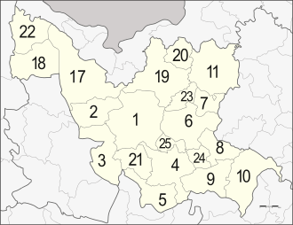
The province is divided into six districts (amphoe). Another five are now in Nong Bua Lamphu Province. The districts are further subdivided into 155 sub-districts (tambon) and 1682 villages (muban):
Transportation
Udon Thani is linked to the rest of Thailand by comprehensive air, road and rail connections. Most of the major highways that run through the northeastern Thailand, including Mittraphap Road, serve Udon Thani as well.
Udon Thani International Airport, the province's primary airport, is in the district of Mueang Udon Thani near the border with Nong Khai Province.
Education
Udon Thani has several tertiary education institutions. Udon Thani is also home to an international school. Most of these academic centres are concentrated in major towns and cities in Udon Thani:
Public universities
| Name | Acronym | Founded | Location |
|---|---|---|---|
| Udon Thani Rajabhat University | UDRU | 1923 | Mueang Udon Thani |
Private universities and university colleges
| Name | Acronym | Founded | Location |
|---|---|---|---|
| Santapol College | STU | 1998 | Mueang Udon Thani |
International schools
| Name | Acronym | Founded | Location |
|---|---|---|---|
| Udon Thani International School | UDIS | 2013 | Mueang Udon Thani |
Healthcare
Notable hospitals in Udon Thani are listed below:
|
Public Hospitals
|
Private Hospitals
|
Media
Television
Television in Udon Thani consists of thirteen free-to-air stations, one satellite television network, and two Internet television services. Seven of the thirteen free-to-air stations are broadcast from Laos (with four foreign relay stations). All of Thai stations are broadcast from Bangkok, except for NBT which has two hours of local programming.
- Free-to-air
- MCOT
- National Broadcasting Services of Thailand (NBT)
- Royal Thai Army
- Public
- Lao National Television
- LNTV 1
- LNTV 3
- MV Lao
- Vietnam Television
- China Central Television
- Satellite television
- Internet television
- UDTV
- Nation Channel (Alternative News Network)
Radio
Radio stations in Udon Thani are available on FM frequencies.
Commercial radio stations available in Udon Thani include Radio One (88.5), New Music (89.0), Cool FM (89.3), SR Radio (89.9), UFM (90.25), Kiss FM (90.75), NN Radio (91.75), Big FM (92.5), Udon FM (97.0), Nice FM (97.25), Live Hits (98.0), WOW FM (98.25), Sayamchai FM (98.5), OK Love (100.0), P Radio (104.4), Mittaphap FM (104.75), Isama Radio (105.25), Wansabai Radio (106.5), and Hit FM (107.0). Commercial radio stations are operated by a few media companies.
Local community radio stations include Rajabhat University Radio (107.7) operated by Udon Thani Rajabhat University (only available in Udon Thani and Phen), EFM (101.25), and Education Radio (96.0) which targets university students.
The seven government radio networks available are Modern Radio (91.5), NBT (93.75), Parliament FM (87.5), Post FM (99.0), Border Patrol FM (100.25), Police FM (105.75), Air Force FM (104.0). The regions of Udon Thani that border other provinces can also receive two other MCOT radio stations; Khon Kaen FM (Udon Thani-Khon Kaen border) and Nong Khai FM (Udon Thani-Nong Khai border).
The radio stations from Laos available are LNR 1 (103.7), LNR 2 (97.3), and Vientiane City Radio (105.5).
Image gallery
-

Huai Luang reservoir
References
- ↑ "Population of the Kingdom" (PDF). Department of Provincial Affairs (DOPA) Thailand (in Thai). 2014-12-31. Retrieved 19 Mar 2015.
- ↑ "Expanded Administrative Units". GeoHive. Retrieved 2014-12-05.
- ↑ Udon Thani Provincial Office (1985), Udon Thani: A History of a Provincial Administration, Bangkok: Amarin Printing.
External links
- Official website
 Udon Thani travel guide from Wikivoyage
 |
Loei | Sakhrai/Mueang, |
 | |
| |
Sawang Daen Din, | |||
| ||||
| | ||||
| Nong Bua Lamphu | Khao Suan Kwang / Kranuan, |
|
| ||||||||||||||||||||||||||||||
|

