Uberlândia
| Uberlândia | ||
|---|---|---|
| Municipality | ||
| Município de Uberlândia Municipality of Uberlândia | ||
|
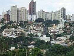
Downtown Uberlandia | ||
| ||
| Nickname(s): Udi, Capital Logistics, Greater Pole Wholesale in Latin America | ||
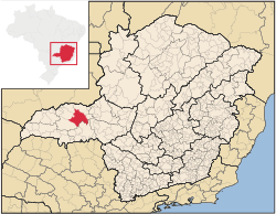
 Localization of Uberlândia in Minas Gerais | ||
 Uberlândia Localization of Uberlândia in Brazil | ||
| Coordinates: 18°55′23″S 48°17′19″W / 18.92306°S 48.28861°W | ||
| Country | Brazil | |
| Region | Southeast | |
| State | Minas Gerais | |
| Founded | August 31, 1888 | |
| Government | ||
| • Mayor | Gilmar Machado (PT) | |
| Area | ||
| • Total | 4,115.9 km2 (1,589.2 sq mi) | |
| Elevation | 863 m (2,831 ft) | |
| Population (2014)[1] | ||
| • Total | 654,681 | |
| • Density | 157,12/km2 (40,690/sq mi) | |
| Demonym(s) | Uberlandense | |
| Time zone | UTC-3 (UTC-3) | |
| • Summer (DST) | UTC-2 (UTC-2) | |
| Postal Code (CEP) | 38400-000 | |
| Area code(s) | +55 34 | |
| Website | www.uberlandia.mg.gov.br | |
| [2] | ||
Uberlândia is a municipality in the state of Minas Gerais, southeastern Brazil.
With a population of 654,681 inhabitants, according to 2014 estimates, the city is the second largest in the state second only to Belo Horizonte (2,491,109).

Geography

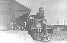
Uberlândia is located in the western part of the state of Minas Gerais, in the region called Triângulo Mineiro, one of the richest agricultural regions of Brazil, between the Paranaíba and Grande rivers. It is connected to major cities by the following federal highways: BR-050, BR-365, BR-455, BR-452, and BR-497. Uberlândia is about 580 km away from São Paulo, connected by a modern and safe double trace highway (BR-050). The capital of the state of Minas Gerais, Belo Horizonte, is 560 km away and Brasília, the capital of the country, lies just 440 km to the north. There are railways connecting Uberlândia via the north-south Centro-Atlântica line.
Uberlândia is a statistical micro-region including the following municipalities: Araguari, Araporã, Canápolis, Cascalho Rico, Centralina, Indianópolis, Monte Alegre de Minas, Prata, Tupaciguara, and Uberlândia. In 2007 the population of these cities' agglomeration was 818,395 inhabitants in a total area of 18,864.20 km². The population density (2000) was 43.38 inhab/km².[3]
Climate
According to the Köppen climate classification Uberlândia has a Tropical savanna climate, but due to its high elevation (about 850 meters), the city experiences mild temperatures all year round. The summer and spring are hotter and humid, while autumn and winter are mild and dry (sometimes cold, when polar waves coming from Antarctica hit the region). The mean annual surface temperature is about 295 Kelvin (22 °C/71 °F).
Economy
Uberlândia's GDP was BRL 12,483,820 mil (about USD 6,911 billions) which results in a GDP per capita of USD 11,360. The region where Uberlândia is located takes in a consumer market of three and a half million inhabitants, being the link between the great urban centers of the coast and the hinterland of the country. In a radius of 600 km around Uberlândia there are 50 million inhabitants, responsible for almost two thirds of the Brazilian GDP (about USD 1,313 trillion, which corresponds to two Argentinian economies).
Uberlândia is the main economic center of this region. It is the eighth city in the country in payment of federal taxes and the twentieth considering all the taxes. It is the third city in Minas Gerais in state taxes, after the capital Belo Horizonte and the municipality of Betim, where several automobile assembly plants are located.
Because of its centrality and good transport links, Uberlândia has been chosen as a distribution point for the Free Economic Zone of Manaus, the first ever such distribution point.[4]
Infrastructure
With its strategic location in the central region of Brazil, the city has some of the best logistics infrastructure in the country: there are eight highways, with one being transformed into a four-lane highway, the FEPASA railway, more than 1.6 million tons of cereal storage capacity and more than five thousand trucks to deliver products to companies.
Self-sufficient in electric power, Uberlândia relies on 12 large power plants in operation and two more under construction in a radius of 250 km.
Ten. Cel. Av. César Bombonato Airport is the second largest facility in Minas Gerais and the 27th largest in Brazil in number of passengers transported, with direct flights operating to São Paulo, Belo Horizonte, Goiânia, Brasília, Ribeirão Preto, Uberaba and charter flights to the state capitals of Northeast Brazil in the high season.
The city has several colleges and many universities, among these is the Universidade Federal de Uberlândia, which has a university population of approximately thirty thousand students and is one of the most important universities in the country.
Shopping
Uberlândia has big brand stores and shopping centers. The main one are: Center Shopping Uberlândia and Uberlândia Shopping.
Major brands are: Carmen Steffens, John John, Crocs, Calvin Klein, Brooksfield, Brooksfield Donna, Brooksfield Jr, Zara, Leroy Merlin, Walmart, Cinemark, McDonald's, Burger King, Audi, BMW, Land Rover, Volvo, Chrysler and many other.
Culture
Religion
Uberlândia has substantial religious diversity. According to the 2010 census, a narrow majority of its citizens are members of the Roman Catholic Church (54.73%), while Evangelical Christians comprise the second largest religious affiliation in the city (25.23%). There are also substantial minorities of Spiritists (7.80%) and those who identify with no religion (7.80%). There are smaller minorities adhering to the Brazilian Catholic Apostolic Church, the Orthodox Church, the Jehovah's Witnesses, The Church of Jesus Christ of Latter-day Saints, Islam, Buddhism, indigenous beliefs, Umbanda and Candomblé, (all below 1% of Uberlândia's population).[5]
See also
References
- ↑ "Estimativas da população residente nos municípios brasileiros com data de referência em 1º de julho de 2014" (PDF). Instituto Brasileiro de Geografia e Estatística (IBGE). 28 August 2014. Retrieved 31 August 2014.
- ↑ IBGE (10 Oct 2002). "Área territorial oficial". Resolução da Presidência do IBGE de n° 5 (R.PR-5/02). Retrieved 5 Dec 2010.
- ↑ Citybrazil
- ↑ http://www.farolcomunitario.com.br/uberlandia_100_0058.htm
- ↑ "Censo 2010: Listas municipios e religiões" (in Portuguese). Ministério de Apoio com Informação. 2010. Retrieved 20 October 2012.
External links
| Wikimedia Commons has media related to Uberlândia. |
| Wikivoyage has a travel guide for Uberlândia. |
| ||||||||||||||||||||||||||||||||||||||
| |||||||||||||||||||||||||||||||||||||||||||||||||||||||||||||||||||||||||||||||||||||||||||||||||||||||||||||||||||||||||||||||||||||||||||||||||||||||||||||||||||||||||||||||||||||||||||||||||||||||||||||||||||||||||||||||||||||||||||||||||||||||||||||||||||||||||||||||||||||||||||||||||||||||||||||||||||||||||||||||||||||||||||||||||||||||


