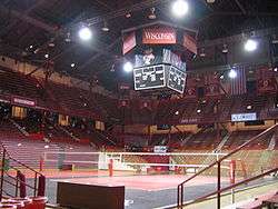
Wisconsin Field House
 | |
| Location |
1450 Monroe St Madison, WI 53711 |
|---|---|
| Owner | Univ. of Wisconsin–Madison |
| Operator | Univ. of Wisconsin–Madison |
| Capacity | 10,600 |
| Construction | |
| Broke ground | September 26, 1929 |
| Opened | December 13, 1930 |
| Construction cost | $434,000 |
| Architect | Arthur Peabody and Paul Cret |
| Tenants | |
|
Wisconsin Badgers Men's Basketball (1930-1998) Wisconsin Badgers Women's Basketball (1974-1998) Wisconsin Badgers Volleyball (1986-Present) Wisconsin Badgers Wrestling (1930-Present) Wisconsin Badgers Boxing (1933-1960) WIAA State Boys Basketball Tournament (1930-1935, 1937-1997) WIAA State Girls Basketball Tournament (1976-1997, 1999-2000, 2002) WIAA State Wrestling Tournament (1930-1997, 2005-Present) | |
|
University of Wisconsin Field House | |
 | |
| Location | 1450 Monroe St., Madison, Wisconsin |
| Architectural style | Other, Italian Renaissance |
| NRHP Reference # | 98000829[1] |
| Added to NRHP | July 1, 1998 |
The Wisconsin Field House (commonly known as the UW Fieldhouse) is an 10,600-seat multi-purpose arena in Madison, Wisconsin, directly south of and abutting Camp Randall Stadium. In addition to sports events, the Field House has been the site of large community gatherings such as convocations and concerts. Designed by Wisconsin State Architect Arthur Peabody in consultation with Paul Cret of the firm of Laird and Cret, the arena opened in 1930. It was home to the Wisconsin Badgers basketball team before it moved to Kohl Center; currently the building is used by the volleyball and wrestling teams. Prior to occupying the Field House, the Badger men's basketball team played their games in the Red Gym. The Wisconsin volleyball team got its first-ever sellout on October 21, 2007, to watch the Badgers play No. 1 Penn State. The "W" crest at the top of the Field House, whose actual designer is unknown, is frequently employed as the emblem of the University of Wisconsin–Madison. The Field House was added to the National Register of Historic Places in 1998.
References
- ↑ Staff (2010-07-09). "National Register Information System". National Register of Historic Places. National Park Service.
- Field House construction details and historic photos
External links
- Field House in The Buildings of the University of Wisconsin
- The Fieldhouse on UWBadgers.com
- Modern appreciation from Wisconsin Builder
Coordinates: 43°04′07″N 89°24′47″W / 43.068613°N 89.412921°W
Gallery
| ||||||||||||||||||||||


.jpg)