U.S. Grant Bridge
| U.S. Grant Bridge (current) | |
|---|---|
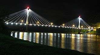
 Current U.S. Grant Bridge carrying US 23 over the Ohio River. | |
| Coordinates | 38°43′39″N 82°59′50″W / 38.72750°N 82.99722°WCoordinates: 38°43′39″N 82°59′50″W / 38.72750°N 82.99722°W |
| Carries |
2 lanes of |
| Crosses | Ohio River |
| Locale | Portsmouth, Ohio and South Shore, Kentucky |
| Maintained by | Ohio Department of Transportation |
| Characteristics | |
| Design | Cable-stayed bridge |
| Total length | 657 m (2155 ft.) |
| Longest span | 267 m (875 ft.) |
| History | |
| Opened | October 16, 2006 at a cost of more than $28,434,495 |
The U.S. Grant Bridge is the name of the two bridges that carry and have carried traffic on U.S. Route 23 between Portsmouth, Ohio and South Shore, Kentucky across the Ohio River in the United States. The original bridge was closed and demolished in 2001 and its replacement opened on October 16, 2006.
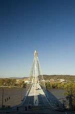
Current U.S. Grant Bridge
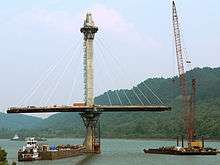
Contracts for the new U.S. Grant Bridge were given in the spring of 2001. Construction was expected to be complete in June 2004, but work fell behind schedule due to inclement weather, unusual flooding of the Ohio River, and the partial sinking of a floating construction barge which carried one of the cranes used to work on the center span of the bridge. The date of completion was moved to October 16, 2006.

In addition, many downtown business owners were upset over the delays and often criticized the construction company, C.J. Mahan Construction Company, for delays on days when it was sunny and the river levels were average. It should be noted that the bridge was critically underdesigned and not constructible until C.J. Mahan stopped construction and awaited a near complete redesign by the design consultant. Another complaint was that this is the first major bridge project the construction company that was awarded the construction contract has worked on. However, C.J. Mahan has constructed other large bridges in Ohio and West Virginia. Local business owners demanded that ODOT pay local businesses $8 million in lost profit.

Original U.S. Grant Bridge
| U.S. Grant Bridge (former) | |
|---|---|
.jpg) 1930s postcard | |
| Coordinates | |
|
General U.S. Grant Bridge | |
 | |
| Location | Ohio R.-Chillicothe and Second St., South Portsmouth, Kentucky |
| Coordinates | 38°43′29″N 82°59′53″W / 38.72472°N 82.99806°W |
| Area | less than one acre |
| Built | 1927 |
| Architect | Robinson and Steinman; et al. |
| Architectural style | Cable suspension bridge |
| NRHP Reference # | 01000560[1] |
| Added to NRHP | May 31, 2001 |
| Carries |
2 lanes of |
| Crosses | Ohio River |
| Locale | Portsmouth, Ohio and South Shore, Kentucky |
| Maintained by | Ohio Department of Transportation |
| Characteristics | |
| Design | Suspension bridge |
| History | |
| Opened | 1927 |
| Closed | 2001 |
| Statistics | |
| Toll | tolls dropped in 1974 |
The original U.S. Grant Bridge was a suspension bridge. The bridge opened to traffic as a toll bridge in 1927. It wasn't until 1974 when the Ohio Department of Transportation bought the bridge from the Ohio Bridge Commission and removed the tolls. The U.S. Grant Bridge was the only automobile bridge in Scioto County to cross the Ohio River which became a nightmare when the bridge closed for repairs in 1978 which then reopened in 1980. However, Scioto County would have more arteries to cross with the Jesse Stuart Memorial Bridge opened in 1984 and the Carl Perkins Bridge opened in 1988.
In 1992, ODOT initiated a long-range study to determine whether to continue to rehabilitate the existing bridge or construct a new span. ODOT had spent $9 million from 1977 to 1996 by the time the study was completed to rehabilitate portions of the bridge. According to the study, rehabilitating the span would add only 20 useful years to the suspension bridge before rehabilitation would need to occur again and would cost nearly $30 million. It was found not cost-efficient to continuously rehabilitate the suspension bridge when a new structure would be cheaper in the long-run. The bridge continued to age and once again closed from repairs in 1994.
On July 3, 2001, the original suspension bridge was permanently closed to traffic and the entire structure was torn down within a few months.
See also
References
- ↑ Staff (2009-03-13). "National Register Information System". National Register of Historic Places. National Park Service.
External links
- C.J. Mahan Construction Company, contractors for the new U.S. Grant Bridge
- U.S. Grant Bridge at Bridges & Tunnels
- U.S. Grant Bridge (Demolished) at Bridges & Tunnels
| |||||||||