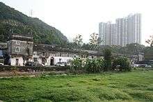
Tsang Tai Uk


Tsang Tai Uk (曾大屋 or "Big House of the Tsangs"), also known as Shan Ha Wai ("Walled Village at the Mountain's Foot"), is a Hakka walled village in Hong Kong,[1] and one of the best preserved. The complex is located in Sha Tin close to the south of Pok Hong Estate, near Lion Rock Tunnel Road.
History
The construction of Shan Ha Wai was begun in 1847 by the wealthy granite merchant and stonemason Tsang Koon-Man as a stronghold for the Tsang clan, and took around 20 years to complete. The original granite, bricks and solid timber are still preserved today. The complex is rectangular and consists of three rows of houses enclosed by grey brick walls. The four corners each feature a three-story guard tower with openings in the wall through which guns could be fired back in the early days of the complex's role as a defensive fortification.[1] All the houses are interlinked by passages and small courtyards. In the innermost row of houses is an ancestral hall where meetings and ceremonies took place. There are three arched entrances in the northern wall. The main or ceremonial entrance is in the middle and leads to the ancestral hall. In front of the main building is a massive courtyard, where villagers traditionally winnowed and dried their harvest.
Shan Ha Wai gained its current name Tsang Tai Uk from locals when it housed displaced families after the Second World War.
Conservation
Tsang Tai Uk is listed as a Grade I historic buildings.[2] Restoration work of the ancestral hall started in 2009, after a HK$ 1m Government grant on maintenance of privately owned graded historic buildings had been approved.[3] Visitors are permitted in the first courtyard and ancestral hall;[4] the remaining courtyards and buildings are private.
Access
MTR Route: Ma On Shan Line to Che Kung Temple or Sha Tin Wai and walk to Tsang Tai Uk
See also
- Mantang Wei (满堂围), in Shixing County of China
References
- 1 2 Brief Information on proposed Grade I Items. Item #1
- ↑ List of the 1,444 Historic Buildings in Building Assessment (as of 27 December 2013)
- ↑ Press release: Financial Secretary visits Tsang Tai Uk, September 16, 2009
- ↑ Approved applications for financial assistance on maintenance of privately-owned graded historic buildings
External links
| Wikimedia Commons has media related to Tsang Tai Uk. |
- Journey Between the Centuries: Sha Tin by DiscoverHongKong.com
- Photos of Tsang Tai Uk
- Google satellite view
Coordinates: 22°22′26″N 114°11′26″E / 22.3738°N 114.1906°E