Transect

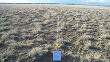
A transect is a path along which one counts and records occurrences of the species of study (e.g. plants)[1].
It requires an observer to move along a fixed path and to count occurrences along the path and, at the same time (in some procedures), obtain the distance of the object from the path. This results in an estimate of the area covered and an estimate of the way in which detectability increases from probability 0 (far from the path) towards 1 (near the path). Using the raw count and this probability function, one can arrive at an estimate of the actual density of objects.

The estimation of the abundance of populations (such as terrestrial mammal species) can be achieved using a number of different types of transect methods, such as strip transects, line transects, belt transects, point transects[2] and curved line transects.[3]
See also
References
- ↑ "Physico-chemical Parameters and Macrobenthic Invertebrates of the Intertidal Zone of Gusa, Cagayan de Oro City, Philippines". www.academia.edu. Retrieved 2015-12-08.
- ↑ Buckland, S.T., Anderson, D.R., Burnham, K.P and Laake, J.L. 1993. Distance Sampling: Estimating Abundance of Biological Populations. London: Chapman and Hall. ISBN 0-412-42660-9 Online version
- ↑ Line Lex Hiby, M. B. Krishna 2001. Transect Sampling from a Curving Path. Biometrics. 57(3):727-731
External links
-
 The dictionary definition of transect at Wiktionary