Tosa, Kōchi
| Tosa 土佐市 | |
|---|---|
| City | |
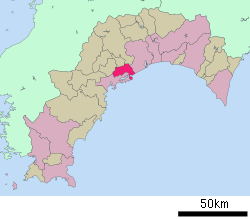
 Location of Tosa in Kōchi Prefecture | |
 Tosa Location in Japan | |
| Coordinates: 33°30′N 133°26′E / 33.500°N 133.433°ECoordinates: 33°30′N 133°26′E / 33.500°N 133.433°E | |
| Country | Japan |
| Region | Shikoku |
| Prefecture | Kōchi Prefecture |
| Government | |
| • Mayor | Yoshifumi Itahara (since October 2007) |
| Area | |
| • Total | 91.59 km2 (35.36 sq mi) |
| Population (December 1, 2011) | |
| • Total | 28,897 |
| • Density | 315.50/km2 (817.1/sq mi) |
| Symbols | |
| • Tree | Ginkgo |
| • Flower | Lilium |
| • Bird | White-cheeked starling |
| Time zone | Japan Standard Time (UTC+9) |
| City Hall Address |
2017-1 Kinoe, Takaoka-chō, Tosa-shi, Kōchi-ken 781-1192 |
| Website |
www |
Tosa (土佐市 Tosa-shi) is a city located in Kōchi Prefecture, Japan. It is located on the southern coast of the island of Shikoku. The city was founded on January 1, 1959.
As of December 1, 2011, the city has an estimated population of 28,897, with 12,080 households and a population density of 315.50 persons per km2. The total area is 91.59 km2.
The city of Tosa should not be confused with the historical Tosa Province, which covered all of modern-day Kōchi Prefecture.
Geography
Tosa is located in central Kōchi Prefecture, and faces the Shikoku Mountain Range to the north and Pacific Ocean to the south. The Niyodo River flows through the Takaoka Plain in the town, where rice is grown.
Surrounding municipalities
Sister cities
- Ebetsu, Hokkaidō, since July 15, 1978
 Itatiba, São Paulo, Brazil, since August 5, 1989
External links
| Wikimedia Commons has media related to Tosa, Kōchi. |
- Tosa City official website (Japanese)
| |||||||||||||||||
|
This article is issued from Wikipedia - version of the Tuesday, November 10, 2015. The text is available under the Creative Commons Attribution/Share Alike but additional terms may apply for the media files.