Ambergate
| Ambergate | |
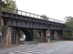
 Railway Viaduct over A6 |
|
 Ambergate |
|
| District | Amber Valley |
|---|---|
| Shire county | Derbyshire |
| Region | East Midlands |
| Country | England |
| Sovereign state | United Kingdom |
| Post town | BELPER |
| Postcode district | DE56 |
| Dialling code | 01773 |
| Police | Derbyshire |
| Fire | Derbyshire |
| Ambulance | East Midlands |
| EU Parliament | East Midlands |
| UK Parliament | Amber Valley |
|
|
Coordinates: 53°03′32″N 1°28′55″W / 53.05883°N 1.48205°W
Ambergate is a village in Derbyshire, England, where the River Amber joins the River Derwent; and where the A610, following the Amber from Ripley and Alfreton, joins the A6 as it runs along the Derwent valley from Belper to the south; Milford, Duffield and Derby further to the south: Whatstandwell, Cromford, Matlock Bath and Matlock to the North. Sawmills, Ridgeway are neighbouring hamlets; Alderwasley, Heage, Nether Heage, and Crich being other significant neighbouring settlements. Ambergate is within the bounds of the Derwent Valley Mills UNESCO site, and has historical connections with George Stephenson; Ambergate is notable for its railway heritage and telephone exchange within those fields of interest. Ambergate has an active community life, particularly centred on the school, pubs, churches, sports clubs; and annual village carnival which is relatively large and consistent locally, with popular associated events in carnival week and throughout the year. The carnival is organised by a voluntary committee. Shining Cliff woods, Thacker's woods and Crich Chase border the village.
It is about 6 miles (9.7 km) south of Matlock at the junction of the A6 trunk road and the A610 to Ripley. A mile east of Ambergate is Heage with its recently restored 18th century windmill.
Until the early nineteenth century it was known as Toadmoor, from the Derbyshire dialect "t'owd moor" [1] (the old moor) with no more than a few artisans' cottages. The southerly half of the present village is still shown as such on the Ordnance Survey's maps. The name Amber Gate was originally applied to the tollgate for the Nottingham turnpike, but adopted by the North Midland Railway for Ambergate railway station which is located on the Derby-Matlock Derwent Valley Line.
The turnpike to Matlock was opened in 1818. Until then the main road from Belper northwards had been through Wirksworth and such traffic as there was, would have been mainly cotton from Arkwright's Mill at Cromford. However, the Cromford Canal, opened in 1794, also passes the village. In 1818 the turnpike to Nottingham was opened with a toll house at the junction.
The canal towpath can be followed from here to Cromford Wharf, passing High Peak Junction, which is the start of the High Peak Trail). This 6-mile (10 km) section is listed as a Biological Site of Special Scientific Interest (SSSI),[2] and also forms part of the Derwent Valley Heritage Way.
In 1840 the North Midland Railway opened with a station at 'Amber Gate' which brought trade for 'omnibus and posting conveyance' to Matlock, which was becoming a fashionable spa town. By 1867 there was a through line from London St.Pancras to Manchester, as well as to Leeds. Ambergate became an important interchange and, in 1876, Francis Hurt built the 'Hurt Arms' to replace the former 'Thatched House Tavern and Posting House' which the Midland Railway had converted into three cottages (now Midland Place). The main railway line runs through the elliptical Toadmoor Tunnel designed by George Stephenson.
In 1791 Benjamin Outram and Samuel Beresford had built kilns at nearby Bullbridge to process limestone from their quarry at Crich. George Stephenson had discovered deposits of coal at Clay Cross and realised that burning lime would provide a use for the slack which otherwise would go to waste. He leased Cliff Quarry at Crich, and built eight limekilns beside the railway. Within a year they had grown to twenty. They were connected by another wagonway known as "The Steep", a 550-yard (500 m) self-acting incline at a slope of 1 in 5.
By 1851 the tiny hamlet had grown to a population of 206. In 1876 Richard Johnson and Nephew opened the wireworks by the river. In 1931 the population had reached 901, rising to 1,794 in 1951.
The quarry and the wagonway closed in 1957 but the limeworks carried on until 1965 and the passage of the Clean Air Act. The kilns were demolished the following year to build a storage facility and processing plant for natural gas.
In 1966 the first fully operational electronic telephone exchange in Europe opened in Ambergate. This was also the first small to medium electronic exchange in the world and the first of many TXE2 type exchanges.[3]
Public houses

Ambergate has three pubs: The Hurt Arms and The White House on the A6 and The Excavator on the A610 at Bucklands Hollow.
References
| Wikimedia Commons has media related to Ambergate. |
- ↑ Farmer. A, (2015) Derwent Valley Mills Through Time, Stroud: Amberley Publishing
- ↑ "Cromford Canal: Site of Special Scientific Interest, Natural England".
- ↑ "Events in Telecommunications History". BT Archives.
- Jewell, R., (1995) Images of Belper & Ambergate, Derby: Breedon Books
- The North Midland Railway Guide, (1842) Republished 1973, Leeds: Turntable Enterprises
- Cooper, B., (1983) Transformation of a Valley: The Derbyshire Derwent, Heinneman, republished 1991 Cromford: Scarthin Books
External links
- View photographic panoramas of Ambergate peakdistrictview.com
- Maps of Ambergate
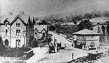
- "Picture the Past" Hurt Arms and the Tollbar circa 1880
- "Picture the Past" The A6 main road through Ambergate (Toadmoor) Toadmoor circa 1930. Very little has changed except that the road has since been paved.
- First production electronic exchange (1966) : Derbyshire's world-beater
- Exploring Ambergate Dye Works