Titi Pinkillu
| Titi Pinkillu | |
|---|---|
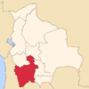
 Titi Pinkillu Location in Bolivia | |
| Highest point | |
| Elevation | 4,529 m (14,859 ft) [1] |
| Coordinates | 19°21′26″S 65°33′27″W / 19.35722°S 65.55750°WCoordinates: 19°21′26″S 65°33′27″W / 19.35722°S 65.55750°W |
| Geography | |
| Location |
Bolivia, Potosí Department |
| Parent range | Andes |
Titi Pinkillu (Quechua titi lead, lead-colored, pinkillu a flute of the Andean region,[2] "lead-colored pinkillu", hispanicized spelling Titi Pinquillo) is a 4,529-metre (14,859 ft) high mountain in the Bolivian Andes. It is situated in the Potosí Department, Cornelio Saavedra Province, Tacobamba Municipality, near the border with the Tomás Frías Province, Potosí Municipality. Titi Pinkillu lies north-east of the lake Urqu Qucha. This is also where the Challwiri River, an affluent of the Pillku Mayu, originates.[1][3]
References
| |||||||||||||||||
This article is issued from Wikipedia - version of the Monday, December 07, 2015. The text is available under the Creative Commons Attribution/Share Alike but additional terms may apply for the media files.
