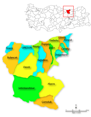
Tirebolu
| Tirebolu | |
|---|---|
 Tirebolu | |
| Coordinates: TR 41°0′20″N 38°49′0″E / 41.00556°N 38.81667°ECoordinates: TR 41°0′20″N 38°49′0″E / 41.00556°N 38.81667°E | |
| Country |
|
| Province | Giresun |
| Government | |
| • Mayor | Abdullah Karapıçak (AKP) |
| • Kaymakam | Ömer Lütfü YARAN |
| Area[1] | |
| • District | 209.67 km2 (80.95 sq mi) |
| Population (2012)[2] | |
| • Urban | 14,828 |
| • District | 29,714 |
| • District density | 140/km2 (370/sq mi) |
| Post code | 28 500 |
| Climate | Cfa |
| Website |
www |
Tirebolu is a town and district of Giresun Province, Turkey.
Geography
Tirebolu itself is a small town of 14,303 people located on the hill named Ayana which rises from the Black Sea shore just to the west of the Harşit River estuary. Tirebolu has a little harbour and a fishing fleet but the mainstay of the local economy is growing hazelnuts.
History
In his Anabasis, the ancient Greek historian Xenophon (431–360 BC) wrote that Colchians, Drilae, Habibs, and Tiberians had been living in the eastern parts of the Black Sea region during the centuries (BC).
The Naturalis Historia of Pliny the Elder recounts that the ancient fortress city of Tripolis was founded (elsewhere dated as 656 BC) as a trading colony of the Ancient Greek city-state of Miletos, one of nearly 90 along the Black Sea coast.
Tripoli was next part of the Roman Empire, Byzantine Empire, one of the three cities that give the town its name, the others being Andoz (today's Espiye) and Bedrama (or Bedrum) in the Harşit valley. When Alexios Komnenos (later Emperor Alexios I of Trebizond) and his brother David founded the Empire of Trebizond in April 1204, about the time the Fourth Crusade captured and sacked Constantinople, Tripoli became part of this empire. As late as 1404, it was part of the direct territory of the Emperor of Trebizond.[3]
Turkish era
During the Trapezuntine period (13th century), the Chepni people settled Tirebolu.[4] The ancient city's name was Turkified into the present name of Tirebolu. In 1916 the coast was occupied by Russian troops for two years during the First World War and Russia restored it back to Turkey in 1917.
References
- ↑ "Area of regions (including lakes), km²". Regional Statistics Database. Turkish Statistical Institute. 2002. Retrieved 2013-03-05.
- ↑ "Population of province/district centers and towns/villages by districts - 2012". Address Based Population Registration System (ABPRS) Database. Turkish Statistical Institute. Retrieved 2013-02-27.
- ↑ Ruy Gonzáles de Clavijo, Narrative of the Embassy of Ruy Gonzalez de Clavijo to the Court of Timour at Samarcand AD 1403-6, translated by Clemens Markham (London: Hakluyt Society, 1859), p. 60
- ↑ Sümer, Faruk, Çepniler
External links
- (Turkish) the municipality
- (Turkish) the district governorate
- Pictures from the castle
- Old photo collection
|
