Thoroton
| Thoroton | |
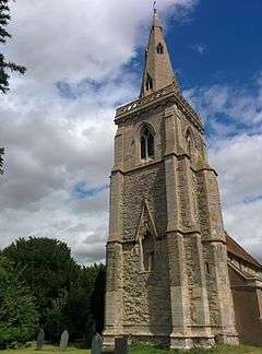
 The church steeple |
|
 Thoroton |
|
| Population | 140 |
|---|---|
| OS grid reference | SK764425 |
| District | Rushcliffe |
| Shire county | Nottinghamshire |
| Region | East Midlands |
| Country | England |
| Sovereign state | United Kingdom |
| Post town | NOTTINGHAM |
| Postcode district | NG13 |
| Dialling code | 01949 |
| Police | Nottinghamshire |
| Fire | Nottinghamshire |
| Ambulance | East Midlands |
| EU Parliament | East Midlands |
|
|
Coordinates: 53°00′N 0°52′W / 53.0°N 0.86°W
Thoroton is a small village located in the parish of Thoroton in Rushcliffe, Nottingham, England, and lies along the banks of the River Smite, about 15 miles (24 km) east of Nottingham and 4 miles (6.4 km) miles northwest of Bingham, and adjacent to Scarrington, Hawksworth, Sibthorpe, Orston and Aslockton.
Thoroton has a population of 110 and was granted conservation area status in 1974. It is served by St Helena's Church. It is bounded by the A46 3 miles (4.8 km) to the west, the A1 3 miles (4.8 km) to the east and the A52 road 2 miles (3.2 km) to the south.
Charles Falconer, Baron Falconer of Thoroton takes his name from part of his wife's name and her family home is near Thoroton.[1] The family also owns property in the village, which they let.
References
- ↑ The Domesday bloke, The Guardian, Retrieved 3 August 2015
External links
![]() Media related to Thoroton at Wikimedia Commons
Media related to Thoroton at Wikimedia Commons