The Remarkables

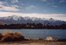
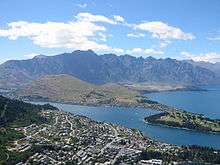
The Remarkables are a mountain range and skifield in Otago in the South Island of New Zealand. Located on the southeastern shore of Lake Wakatipu, the range lives up to its name by rising sharply to create an impressive backdrop for the waters. The range is clearly visible from the nearby town of Queenstown.
The highest point in the range is Double Cone (2319 metres). The adjacent Hector Mountains southeast of the Remarkables culminate in Mount Tuwhakaroria (2307 m).[1]
There are a number of small lakes on the mountains including Lake Alta which forms part of the Remarkables Skifield.
The mountains were named The Remarkables by Alexander Garvie in 1857-58,[2] allegedly because they are one of only two mountain ranges in the world which run directly north to south. An alternate explanation for the name given by locals is that early Queenstown settlers, upon seeing the mountain range during sunset one evening, named them the Remarkables to describe the sight.
Skifield
During the winter months The Remarkables skifield has skiing and other winter activities. The ski area has three mountain bowls covering 540 acres (2.2 km²). The patrolled area covers 220 ha with six lifts (3 quad chairs, 3 magic carpets, and a tow rope). Terrain is rated as 30% beginners, 40% intermediate and 30% advanced. The whole skifield area is 540 acres (2.2 km²) with six lifts. Average annual snowfall is 3.67 metres. In 2007 automated snowmaking was installed and a new snow groomer has also been acquired.[3] There's also a snow tubing park and in 2008 a terrain park was developed. The Remarkables are part of NZSki, which incorporate Coronet Peak and Mt Hutt.

| The Remarkables Skifields | |
|---|---|
| Elevation | 1943 metres |
| Vertical | 357 metres |
| Skiable Area | 220 hectares |
| Lifts | 3 quad chairs, 3 surface conveyor lifts, 1 handle tow Highest lifted point: 1943 metres Lowest lift: 1622 metres |
| Lift Operation | 9.00am - 4.00pm |
| Terrain | 30% Beginner, 40% Intermediate, 30% Advanced |
| Standard Season | 18 June - 16 October |
| Average Snowfall | 3.67 metres per year (excluding snowmaking) |
| Snowmaking | Halfpipe, terrain park, beginners' area, Alta Green, Casterway, Gotham City & Turquoise novice trails and Ozone Tubing Park |
| Nearest Town | Queenstown (28 km/45 minutes) |
| Shuttle Services | Multiple daily return services from Queenstown |


References
- ↑ Central Otago names confirmed, Waatea News, 11 Dec 2013
- ↑ Miller. F.W.G. (1949) Golden Days of Lake County. Whitcomb and Toombs. Pg 352.
- ↑ Louisson, Simon (4 April 2007). "Queenstown pushes power of popularity". New Zealand Herald. Retrieved 21 November 2011.
External links
| Wikimedia Commons has media related to The Remarkables. |
Coordinates: 45°09′S 168°50′E / 45.150°S 168.833°E
| ||||||||||||||||||||||||||||||||||||||||||||||||||||||
| ||||||||||||||||||||||||||||||||||||||||||||||||||||||||||||||||||||||||||||||||