Tevis Block
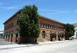
The Tevis Block, also known as the Kern County Land Company Building, is a historic office building in Bakersfield, California. The structure was placed on the National Register of Historic Places (NRHP) on March 29, 1984.
Structure
The Tevis Block is a two-story, U-shaped structure constructed of imported fire brick. The front, south-facing facade has fanlight windows and terra cotta arches. Each floor is articulated differently and treated with a different order and finish. Basement windows are rectangular and bottom-hinged with a flat lintel. The first floor windows, two-sash and divided vertically with the fanlight transom, are enhanced by the brickwork to give the appearance of including mezzanine windows. The second-story windows are single-light sash with flat radiating bricks above. Above the second-story windows is a narrow frieze with square vents topped by a decorated boxed cornice capped by a high plain cornice. The rear of the building includes an enclosed elevator, added later, and a second-story, iron-railed walkway. An additional one-story brick wing was added to the building northwest corner in later years.[2]
Significance
The Tevis Block is the final vestige of the Kern County Land Company.[2] The Company was formed in 1890 by James Haggin and his brother-in-law Lloyd Tevis and prospered in developing the areas around the Kern River.[3] The building helped open up the Bakersfield downtown west of H Street and became a landmark upon construction. It was one of only a handful of unreinforced masonry buildings to survive the 1952 Kern County earthquake, and was subsequently strengthened, renovated and restored to a close proximity of its original architecture. It is considered a fine example of Second Renaissance Revival architecture.[2]
See also
References
- ↑ Staff (2009-03-13). "National Register Information System". National Register of Historic Places. National Park Service.
- 1 2 3 Chris Brewer, Historic Resources Inventory, State of California -- The Resources Agency, Department of Parks and Recreation, April 3, 1984; copy accessed from City of Bakersfield Cultural Resources Survey Downtown Area, located in the Local History room of the Beale Memorial Library, Bakersfield, California.
- ↑ Carleton E. Watkins Photography Collection, Kern County Library, Accessed December 28, 2010.
|
|---|
| | Districts | |
|---|
| | Sports Venues | |
|---|
| | Performance Venues | |
|---|
| | Museums | |
|---|
| | Points of Interest | |
|---|
| |
|
|
|---|
| | |
|---|
| | National Parks | |
|---|
| | National Preserves | |
|---|
| | National Monuments | |
|---|
| | National Seashores | |
|---|
| | National Historical Parks | |
|---|
| | National Historic Sites | |
|---|
| | National Memorials | |
|---|
| | National Recreation Areas | |
|---|
|
| | | |
|---|
| | State Parks | |
|---|
| State
Natural Reserves | |
|---|
| State
Marine Reserves | |
|---|
| State
Historic Parks | |
|---|
| | State Beaches | |
|---|
| State
Recreation Areas | |
|---|
| State Vehicular
Recreation Areas |
- Carnegie
- Clay Pit
- Heber Dunes
- Hollister Hills
- Hungry Valley
- Oceano Dunes
- Ocotillo Wells
- Prairie City
|
|---|
| | Other | |
|---|
|
| | | |
|---|
| National Forests
and Grasslands | |
|---|
| National Wilderness
Preservation System | |
|---|
| National Monuments
and Recreation Areas | |
|---|
|
| | | | | | | |
|---|
| Wildlife
Areas | |
|---|
| Ecological
Reserves |
- Albany Mudflats
- Alkali Sink
- Allensworth
- Atascadero Creek Marsh
- Bair Island
- Baldwin Lake
- Batiquitos Lagoon
- Blue Sky
- Boden Canyon
- Boggs Lake
- Bolsa Chica
- Bonny Doon
- Buena Vista Lagoon
- Butler Slough
- Butte Creek Canyon
- Butte Creek House
- Buttonwillow
- By Day Creek
- Calhoun Cut
- Canebrake
- Carlsbad Highlands
- Carmel Bay
- Carrizo Canyon
- Carrizo Plains
- China Point
- Clover Creek
- Coachella Valley
- Coal Canyon
- Corte Madera Marsh
- Crestridge
- Dairy Mart Ponds
- Dales Lake
- Del Mar Landing
- Eden Landing
- Elkhorn Slough
- Estelle Mountain
- Fall River Mills
- Fish Slough
- Fremont Valley
- Goleta Slough
- Indian Joe Spring
- Kaweah
- Kerman
- King Clone
- Laguna Laurel
- Loch Lomond Vernal Pool
- Lokern
- Magnesia Spring
- Marin Islands
- Mattole River
- McGinty Mountain
- Morro Dunes
- Morro Rock
- Napa River
- North Table Mountain
- Oasis Spring
- Panoche Hills
- Peytonia Slough
- Pine Hill
- Piute Creek
- Pleasant Valley
- Rancho Jamul
- Redwood Shores
- River Springs Lakes
- Saline Valley
- San Dieguito Lagoon
- San Elijo Lagoon
- San Felipe Creek
- San Joaquin River
- Santa Rosa Plateau
- Springville
- Stone Corral
- Sycamore Canyon
- Sycuan Peak
- Thomes Creek
- Tomales Bay
- Upper Newport Bay
- Watsonville Slough
- West Mojave Desert
- Woodbridge
- Yaudanchi
|
|---|
| Marine
Protected
Areas | |
|---|
|
| | | |
|---|
| | National Monuments | |
|---|
| National
Conservation Areas | |
|---|
| | Wilderness Areas | |
|---|
|
| | | | | | | | |
|
|
|---|
| | Topics | |
|---|
| | Lists by states | |
|---|
| | Lists by insular areas | |
|---|
| | Lists by associated states | |
|---|
| | Other areas | |
|---|
|
-
 Category Category
-
 Portal Portal
-
 WikiProject WikiProject
|
|

