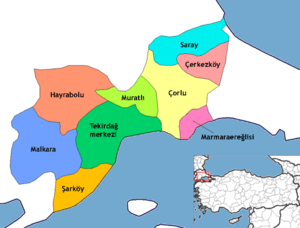
Tekirdağ Province
| Tekirdağ Province Tekirdağ ili | |
|---|---|
| Province of Turkey | |
 Location of Tekirdağ Province in Turkey | |
| Country | Turkey |
| Region | West Marmara |
| Subregion | Tekirdağ |
| Government | |
| • Electoral district | Tekirdağ |
| Area | |
| • Total | 6,218 km2 (2,401 sq mi) |
| Population (2010-12-31)[1] | |
| • Total | 798,109 |
| • Density | 130/km2 (330/sq mi) |
| Area code(s) | 0282 |
| Vehicle registration | 59 |
Tekirdağ Province (Turkish: Tekirdağ ili , pronounced [teˈkiɾdaː]) is in East Thrace, the European part of northwestern Turkey.
Agriculture
The province of Tekirdağ is Turkey's one of the most important regions for viticulture and winemaking. The coastline between Tekirdağ and Şarköy, particularly Mürefte, are notable centers of wineyards. 22 of the 27 villages of Şarköy grow grape and produce wine. There are well-known wine producers in the region, including "Doluca", "Gülor", "Kutman", "Bağcı" and "Latif Aral". Other wine producers of the region are "Melen" in Hoşköy, Şarköy and "Umurbey" in Tekirdağ.[2]
Districts
References
- ↑ Turkish Statistical Institute, MS Excel document – Population of province/district centers and towns/villages and population growth rate by provinces
- ↑ Akyol, Cahit (2005-06-04). "İşte Türkiye'nin şaraplık üzüm haritası". Hürriyet (in Turkish). Retrieved 2015-07-28.
External links
![]() Media related to Tekirdağ Province at Wikimedia Commons
Media related to Tekirdağ Province at Wikimedia Commons
- Tekirdağ governor's official website (Turkish) / (English)
- Tekirdağ municipality's official website (Turkish)
- Tekirdağ weather forecast information
Coordinates: 41°05′11″N 27°21′28″E / 41.08639°N 27.35778°E
| |||||||||||||
This article is issued from Wikipedia - version of the Wednesday, November 18, 2015. The text is available under the Creative Commons Attribution/Share Alike but additional terms may apply for the media files.
