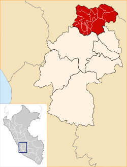
Tayacaja Province
| Tayacaja | ||
|---|---|---|
| Province | ||
|
| ||
| ||
 Location of Tayacaja in the Huancavelica Region | ||
| Country | Peru | |
| Region | Huancavelica | |
| Capital | Pampas | |
| Government | ||
| • Mayor | Jesus Americo Monge Abad (2007) | |
| Area | ||
| • Total | 3,370.6 km2 (1,301.4 sq mi) | |
| Population | ||
| • Total | 104,378 | |
| • Density | 31/km2 (80/sq mi) | |
| UBIGEO | 0907 | |
The Tayacaja Province is one of seven provinces located in the Huancavelica Region of Peru. The capital of this province is the city of Pampas. The province has a population of 116,371 inhabitants as of 2002.
Boundaries
- North: Junín Region
- East: Ayacucho Region, Churcampa Province
- South: Huancavelica Province
- West: Junín Region
Political division
The is divided into eighteen districts, which are:
- Acostambo (Acostambo)
- Acraquia (Acraquia)
- Ahuaycha (Ahuaycha)
- Colcabamba (Colcabamba)
- Daniel Hernández (Mariscal Cáceres)
- Huachocolpa (Huachocolpa)
- Huaribamba (Huaribamba)
- Ñahuimpuquio (Ñahuimpuquio)
- Pampas (Pampas)
- Pazos (Pazos)
- Quishuar (Quishuar)
- Salcabamba (Salcabamba)
- Salcahuasi (Salcahuasi)
- San Marcos de Rocchac (San Marcos de Rocchac)
- Surcubamba (Surcubamba)
- Tintay Puncu (Tintay)
- Andaymarca (Andaymarca)
- Quichuas (Quichuas)
Ethnic groups
The people in the province are mainly indigenous citizens of Quechua descent. Quechua is the language which the majority of the population (65.11%) learnt to speak in childhood, 34.51% of the residents started speaking using the Spanish language (2007 Peru Census).[1]
See also
Sources
- ↑ inei.gob.pe INEI, Peru, Censos Nacionales 2007
| ||||||
Coordinates: 12°23′53″S 74°52′04″W / 12.398156°S 74.867728°W
This article is issued from Wikipedia - version of the Sunday, February 14, 2016. The text is available under the Creative Commons Attribution/Share Alike but additional terms may apply for the media files.

