Tateyama Kurobe Alpine Route


The Tateyama Kurobe Alpine Route (立山黒部アルペンルート Tateyama Kurobe Arupen Rūto) is a famous mountain sightseeing route between Tateyama, Toyama and Ōmachi, Nagano, Japan. The whole route opened on June 1, 1971.
Overview
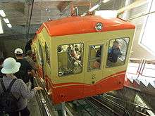
The route is just 37 km in length, but the vertical interval is as large as 1,975m. It uses 7 different public transports with 5 different modes, namely funicular, bus, trolleybus, aerial tramway, and walking.
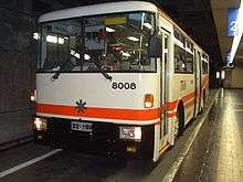
The route is carefully built so that the surrounding environment is not damaged. Consequently, three lines go entirely under tunnels. (This is also to protect the lines from snow.) Among them, two are trolleybus lines. Trolleybuses have all gone from Japan, except for these two lines which are still used here as they don't exhaust fumes in the tunnels.
The route goes through Tateyama in the Hida Mountains with a lot of scenic sites, including Kurobe dam. Some stations have hotels around them and are used as bases for mountain climbing or trekking.
The section between Kurobe Dam and Ōgisawa was originally made for construction of the dam, while the section between Tateyama and Kurobeko was for tourists from the beginning. Currently, the route is purely a sightseeing one, only used by tourists. Although this is the only route that directly links Toyama and Nagano, it is impractical for normal users as it takes 6 transfers, roughly 5 hours, and costs ¥8,060 just between Tateyama and Ōgisawa.
Yukino-ōtani is the most famous sightseeing spot from April to June. You can enjoy the greatest snow walls just before Murodō along this route.
Tateyama Kurobe Kankō
The Tateyama Kurobe Kankō (立山黒部貫光) is a public transport company that operates most lines in the route. Its official abbreviation is TKK. The word kankō (貫光) was coined by Muneyoshi Saeki, the first president of the company. According to him, kan (貫) means "time-space", and kō (光) means "outer space",[1] while kan (貫) also (normally) means "to penetrate", as in "to penetrate Tateyama Mountains" and kō (normally) means "light". The word is a homophone to kankō (観光; "sightseeing"), possibly intentionally.
Lines and stations

| Transfer station / terminus | Elevation | Transport mode | Line name | Distance | Location | |
|---|---|---|---|---|---|---|
| Dentetsu-Toyama (電鉄富山) | 7 m | Railway | Toyama Chiho Railway: Main Line, Tateyama Line 1 | 34 km | Toyama | Toyama |
| Tateyama (立山) | 475 m | Tateyama | ||||
| Funicular | TKK: Tateyama Cable Car | 1.3 km | ||||
| Bijodaira (美女平) | 977 m | |||||
| Bus | TKK: Tateyama Highland Bus | 23 km | ||||
| Murodō (室堂) | 2,450 m | |||||
| Trolleybus | TKK: Tateyama Tunnel Trolley Bus 2 | 3.7 km | ||||
| Daikanbō (大観峰) | 2,316 m | |||||
| Aerial tramway | TKK: Tateyama Ropeway | 1.7 km | ||||
| Kurobedaira (黒部平) | 1,828 m | |||||
| Funicular | TKK: Kurobe Cable Car 2 | 0.8 km | ||||
| Kurobeko (黒部湖) | 1,455 m | |||||
| Walking | (15 minutes walk on Kurobe dam) | |||||
| Kurobe Dam (黒部ダム) | 1,455 m | |||||
| Trolleybus | Kansai Electric Power Company: Kanden Tunnel Trolley Bus 2 | 6.1 km | ||||
| Ōgisawa (扇沢) | 1,433 m | Ōmachi | Nagano | |||
| Bus | Kawanakajima Bus, Kita Alps Kōtsū, and Matsumoto Electric Railway: Ōmachi Alpine Line Bus 1 | 18 km | ||||
| Shinano-Ōmachi (信濃大町) | 713 m | |||||
- 1: Sometimes considered as a part of the route. However, most guided tours use chartered buses for this section.
- 2: The line goes entirely under a tunnel.
Gallery
-

Tateyama Cable Car
-

Tateyama Tunnel Trolley Bus
-

Tateyama Ropeway
-

Kurobe Cable Car
-

Kanden Tunnel Trolley Bus
See also
References
External links
| Wikimedia Commons has media related to Tateyama Kurobe Alpine Route. |
| Wikivoyage has a travel guide for Tateyama Kurobe Alpine Route. |
- Tateyama Kurobe Alpine Route official website
- (Japanese) Tateyama Kurobe Alpine Route official website
- (Japanese) Tateyama Kurobe Alpine Route corporations official website
- Kurobe Alpine Route| Daisuki Japan - Japan Travel Guide
| ||||||||||||||||||||||||||||||||||||||||||||||