Tartini Square

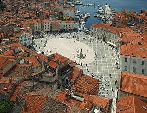
Tartini Square (Slovene: Tartinijev trg, Italian: Piazza Tartini) is the largest and main square in the town of Piran, Slovenia. It was named after violinist and composer Giuseppe Tartini, of whom a monument was made in 1896.
History
The square was once an inner dock for smaller vessels such as fishing boats, and was located outside of the first city walls. In the Middle Ages (MA), the dock became surrounded by important buildings and palaces, because of which it became an important site of the town. However, because of sewage which ended up there, the officials decided to bury the dock and set up a real square there in 1894. Around the newly created platform various new buildings appeared, of which the only one that still has the original exterior is the Gothic house named Benečanka.
The sculptor of the 1896 bronze monument to Tartini was Antonio Dal Zòtto.
From 1909 to 1912, a trolleybus path was made which connected Piran to the train station in Lucija where the Parenzana railway was made, which connected Trieste and Poreč with various other towns. After 1912, the trolleybus was replaced by the more efficient tram, which was operational until 1953 when it was abolished. After the tram railways were put away, a huge renovation of the square occurred, when an ellipse platform was formed out of white stone, designed by architect Boris Podrecca.
Present
In recent years there have been some changes to reduce the number of personal vehicles within the square, in favor of tourism, so during the main season (July 1 to September 1) no vehicles are allowed to park within the square; instead they have to park in the town's car park in Fornače. There is also a line of free mini-buses which drive from Piran to various other coastal towns in the main season.
Gallery
-

Giuseppe Tartini statue
-

Aerial view
-

The docks before the platform of the square was made
See also
References
External links
| Wikimedia Commons has media related to Tartini Square. |
- Municipality of Piran
- Piran on Geopedia
-
 Piran travel guide from Wikivoyage
| ||||||||||||||||
Coordinates: 45°31′42.66″N 13°34′6.22″E / 45.5285167°N 13.5683944°E
