Suwa, Nagano
| Suwa 諏訪市 | ||
|---|---|---|
| City | ||
|
Onbashira in Suwa Taisha, which is held once every six years | ||
| ||
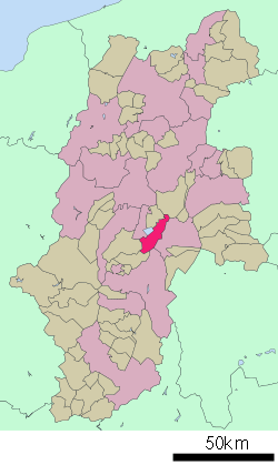
 Location of Suwa in Nagano Prefecture | ||
 Suwa Location in Japan | ||
| Coordinates: 36°2′N 138°7′E / 36.033°N 138.117°ECoordinates: 36°2′N 138°7′E / 36.033°N 138.117°E | ||
| Country | Japan | |
| Region | Chūbu (Kōshin'etsu) | |
| Prefecture | Nagano Prefecture | |
| Government | ||
| • Mayor | Katsufumi Yamada | |
| Area | ||
| • Total | 109.91 km2 (42.44 sq mi) | |
| Population (October 1, 2010) | ||
| • Total | 51,084 | |
| • Density | 468.40/km2 (1,213.2/sq mi) | |
| Symbols | ||
| • Flower | Iris and Lily | |
| Time zone | Japan Standard Time (UTC+9) | |
| City Hall Address |
1-22-30 Takashima, Suwa-shi, Nagano-ken 392-8511 | |
| Website |
www | |
Suwa (諏訪市 Suwa-shi) is a city on the shore of Lake Suwa, in central Nagano Prefecture, Japan.
History
The city was founded on August 10, 1941, after the merger of the town of Kami-Suwa, and the villages of Shiga and Toyoda (all from Suwa District).
Description
As of October 1, 2010, the city has an estimated population of 51,084 and a population density of 468.40 persons per km². The total area of the city is 109.06 km².
The Suwa region is the leading industrial area of Nagano and was once known as "The Oriental Switzerland" in Japan for its highly developed precision machinery industry.[1] Seiko Epson Corporation, a manufacturer of information-related equipment and Seiko timepieces, is headquartered in Suwa.[2]
Suwa has a sister city in the United States: St. Louis, Missouri. There, some Japanese businesses with U.S. operations include Aluman Foils, Inc., Consolidated Gran & Dick Proctor Imports, Inc., Mitsubishi Trading Co., Marubeni, Nissho-Iwai, Bio Kyowa Chemical Co., and Koken Manufacturing.[3]
Climate
Suwa has a humid continental climate (Köppen climate classification Dfa) with very warm summers and cold winters. Precipitation is significantly higher during the summer wet season from June to September than in the winter.
| Climate data for Suwa, Nagano | |||||||||||||
|---|---|---|---|---|---|---|---|---|---|---|---|---|---|
| Month | Jan | Feb | Mar | Apr | May | Jun | Jul | Aug | Sep | Oct | Nov | Dec | Year |
| Average high °C (°F) | 3.2 (37.8) |
4.0 (39.2) |
8.3 (46.9) |
15.8 (60.4) |
20.9 (69.6) |
23.7 (74.7) |
27.3 (81.1) |
28.7 (83.7) |
23.7 (74.7) |
17.5 (63.5) |
12.1 (53.8) |
6.4 (43.5) |
15.97 (60.74) |
| Daily mean °C (°F) | −2.0 (28.4) |
−1.4 (29.5) |
2.5 (36.5) |
9.5 (49.1) |
14.7 (58.5) |
18.5 (65.3) |
22.3 (72.1) |
23.2 (73.8) |
18.8 (65.8) |
12.0 (53.6) |
6.4 (43.5) |
1.1 (34) |
10.47 (50.84) |
| Average low °C (°F) | −6.8 (19.8) |
−6.3 (20.7) |
−2.5 (27.5) |
3.9 (39) |
9.1 (48.4) |
14.3 (57.7) |
18.6 (65.5) |
19.3 (66.7) |
15.0 (59) |
7.6 (45.7) |
1.6 (34.9) |
−3.5 (25.7) |
5.86 (42.55) |
| Average precipitation mm (inches) | 39.4 (1.551) |
56.0 (2.205) |
83.9 (3.303) |
109.4 (4.307) |
109.8 (4.323) |
200.8 (7.906) |
214.2 (8.433) |
129.4 (5.094) |
183.9 (7.24) |
100.2 (3.945) |
65.3 (2.571) |
35.1 (1.382) |
1,327.4 (52.26) |
| Average snowfall cm (inches) | 23 (9.1) |
30 (11.8) |
16 (6.3) |
1 (0.4) |
0 (0) |
0 (0) |
0 (0) |
0 (0) |
0 (0) |
0 (0) |
1 (0.4) |
8 (3.1) |
79 (31.1) |
| Average relative humidity (%) | 72 | 72 | 69 | 67 | 68 | 75 | 78 | 76 | 79 | 78 | 75 | 73 | 73.5 |
| Mean monthly sunshine hours | 178.9 | 167.1 | 196.0 | 191.8 | 213.2 | 160.2 | 168.4 | 196.4 | 140.9 | 154.3 | 158.3 | 170.5 | 2,096 |
| Source: NOAA (1961-1990)[4] | |||||||||||||
Prominent features
The town is famous for its ryokans (onsen hotels, i.e., traditional Japanese guesthouses at hot springs). It forms the backdrop for much of Sayo Masuda's Autobiography of a Geisha.
Annual fireworks displays are held in August and September. The displays take place on the shores of the lake, and many tens of thousands of spectators enjoy the shows from the shores. Trains are the recommended way to get to Suwa on those days, though buses are significantly less expensive.
Every six years (in the years of the Tiger and the Monkey), Suwa hosts a Shinto festival called Onbashira (literally, "the honored log"). As part of the event, very large trees up in the hills are felled and brought down into the valley, pulling them with ropes and sliding them down hills. To demonstrate their bravery, young men from the area ride on the logs as they hurtle down the slopes.
Education
Colégio Sal e Luz, a Brazilian school, was previously located in Suwa.[5] It moved to Okaya.[6]
See also
References
- ↑ "Suwa Area, Web Site Shinshu". Nagano Prefectural Government. 2001-11-26. Archived from the original on March 8, 2006. Retrieved 2007-12-17.
- ↑ "Head Office & Japanese Facilities." Seiko Epson. Retrieved on January 13, 2009.
- ↑ St. Louis Center for International Relations. Retrieved on 3 June 2009.
- ↑ "Suwa Climate Normals 1961-1990". National Oceanic and Atmospheric Administration. Retrieved December 31, 2012.
- ↑ "Escolas Brasileiras Homologadas no Japão" (Archive). Embassy of Brazil in Tokyo. February 7, 2008. Retrieved on October 13, 2015.
- ↑ "Escolas Brasileiras Homologadas no Japão" (Archive). Embassy of Brazil in Tokyo. Retrieved on October 13, 2015.
External links
| Wikimedia Commons has media related to Suwa, Nagano. |
- Suwa City official website (Japanese)
- Onbashira website (Japanese)
| ||||||||||||||
|
