Sud Yungas Province
| Sud Yungas / Sur Yungas | |
|---|---|
| Province | |
|
| |
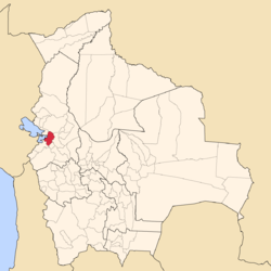
 Location of Sur Yungas Province within Bolivia | |
 Provinces of the La Paz Department | |
| Coordinates: 16°0′0″S 67°5′0″W / 16.00000°S 67.08333°W | |
| Country |
|
| Department | La Paz Department |
| Municipalities | 5 |
| Founded | January 12, 1900 |
| Capital | Chulumani |
| Area | |
| • Total | 5,770 km2 (2,230 sq mi) |
| Population (2012 census) | |
| • Total | 105,013 |
| • Density | 18/km2 (47/sq mi) |
| • Ethnicities | Aymara |
| Website | Official website |
Sud Yungas or Sur Yungas is a province in the Bolivian department of La Paz. It was created during the presidency of José Manuel Pando on January 12, 1900.[1] The capital of the province is Chulumani.
Geography
The Cordillera Real traverses the province. The highest peaks of the province is Illimani at 6,438 m (21,122 ft) above sea level. Other mountains are listed below:[2]
- Allpaqani
- Churu
- Ch'iyar Quta
- Inka
- Jathi Qullu
- K'ara K'arani
- K'illimani
- Layqa Qullu
- Llaytuwani
- Link'u Link'u
- Mik'aya
- Pararani
- Pirqa Pata
- Pirqata
- Pupusani
- Qalsata
- Qaqinkura
- Qutapata
- Sura Qullu
- Sura Surani
- Turini
- Thiya Quta
- Wak'ani
- Wanakuni
- Wisk'achani
Subdivision
The province is divided into five municipalities.
| Municipality | Inhabitants (2001) [3] | Seat | Inhabitants (2001) |
|---|---|---|---|
| Chulumani Municipality | 13,204 | Chulumani | 2,724 |
| Irupana Municipality | 11,383 | Irupana | 1,882 |
| Yanacachi Municipality | 4,250 | Yanacachi | 504 |
| Palos Blancos Municipality | 16,786 | Palos Blancos | 2,961 |
| La Asunta Municipality | 18,016 | La Asunta | 1,466 |
See also
References
- ↑ Official website
- ↑ Bolivian IGM map 1:50,000 Lambate 6044-II
- ↑ Instituto Nacional de Estadística (Spanish)
Coordinates: 16°00′S 67°05′W / 16.000°S 67.083°W
This article is issued from Wikipedia - version of the Sunday, February 14, 2016. The text is available under the Creative Commons Attribution/Share Alike but additional terms may apply for the media files.

