St. Paul's Bay
| Saint Paul's Bay San Pawl il-Baħar | |||
|---|---|---|---|
| Local council | |||
|
St. Paul's Bay | |||
| |||
|
Motto: In Christo Renati Sumus (Born again in Christ) | |||
 | |||
| Coordinates: 35°56′54″N 14°24′6″E / 35.94833°N 14.40167°ECoordinates: 35°56′54″N 14°24′6″E / 35.94833°N 14.40167°E | |||
| Country |
| ||
| Region | Northern Region | ||
| District | Northern District | ||
| Borders | Mellieħa, Mġarr, Mosta, Naxxar | ||
| Government | |||
| • Mayor | Graziella Galea (PN) | ||
| Area | |||
| • Total | 14.47 km2 (5.59 sq mi) | ||
| Population (March 2014) | |||
| • Total | 21,046 | ||
| • Density | 1,500/km2 (3,800/sq mi) | ||
| Population exceeds 60,000 in summer[1] | |||
| Demonym(s) | Pawlin (m), Pawlina (f), Pawlini (pl) | ||
| Time zone | CET (UTC+1) | ||
| • Summer (DST) | CEST (UTC+2) | ||
| Postal code | SPB | ||
| Dialing code | 356 | ||
| ISO 3166 code | MT-51 | ||
| Patron saints |
Our Lady of Sorrows Sacred Heart of Mary St. Francis of Assisi | ||
| Website | Official website | ||
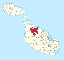
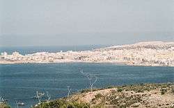
Saint Paul's Bay (Maltese: San Pawl il-Baħar, Italian: Baia di San Paolo) is a town in the Northern Region of Malta. It is situated sixteen kilometres (9.9 miles) northwest of the capital city Valletta. Saint Paul's Bay is largest town in the Northern Region and the seat of the Northern Regional Committee.
Its name refers to the shipwreck of Saint Paul, as documented in the Acts of the Apostles, due to the tradition that Saint Paul was shipwrecked on the isles, named St. Paul's Islands, which are situated near St Paul's Bay. According to the Bible, St. Paul was shipwrecked on an island which many scholars have identified as Malta on his voyage from Caesarea to Rome. The Maltese people believe that it was St. Paul who laid the foundations of Christianity on the island.
The localities of Burmarrad, Qawra, Buġibba, Xemxija, Mselliet, and San Martin as well as part of Bidnija and Mistra, form part of St. Paul's Bay Local Council. The area of the locality is 14.47 km2 (6 sq mi).
The resident population as of March 2014 stood at 21,046 persons.[2] This population goes up to about 60,000 during the period of June to September. The increase is due both to Maltese summer residents and tourists lodging in hotels, especially in Buġibba and Qawra.
Although the town is a modern tourist area there are some very pretty natural highlights close by. Heading north there is Mistra Bay, its headland and St Paul's Island. Going west and crossing the island towards Ġnejna Bay and Golden Bay is the scenic Wardija Ridge.
History
Archaeological remains have been found in the limits of St. Paul's Bay, which go back to around 4000 BC. Among the remains there are the megalithic temples of Buġibba and Xemxija. In addition, cart Ruts were found on the Wardija Ridge at Busewdien,[3] while Punic tombs and other Bronze Age remains were also found. During the Roman period, St. Paul's Bay became an important harbour. Remains of a Roman road, baths and beehives, have been found at Xemxija, while Roman anchors were found on the seabed.
By the late Middle Ages, St. Paul's Bay was abandoned since the area was unsafe due to corsair raids. The local militia maintained several watch posts in the area. One of these, known as Ta' Tabibu farmhouse, still survives today and is considered to be the oldest building in St. Paul's Bay.[4]
A number of fortifications were built in the area during the rule of the Order of Saint John. The first of these was the Wignacourt Tower, built in 1610, which is now the oldest surviving watchtower in Malta. Qawra Tower was built by Grand Master Lascaris in 1638. In 1715, batteries were built around these two towers, while three redoubts were built in other parts of the St. Paul's Bay coastline. Of these, only Arrias Battery survives today, since Dellija Redoubt and Perellos Redoubt were demolished in the 20th century.
The bay was one of the landing places during the French invasion of Malta in June 1798. After the Maltese uprising against the French, St. Paul's Bay became the main harbour of Malta since the Grand Harbour and Marsamxett were still under French control.[5]
In the 19th century, several villas were built in St. Paul's Bay. These were requisitioned by the British military in World War II and the bay became a rest camp. After the Italian armistice of 1943, 76 ships of the Regia Marina were anchored at St. Paul's Bay after surrendering to the British.
After the war, the area began to be further developed. Today, St. Paul's Bay, Qawra, Buġibba, Xemxija and Burmarrad form a large cluster of buildings. The area is a popular entertainment spot.[1]
Zones in St. Paul's Bay
|
|
Main Roads
St. Paul's Bay
- Dawret San Pawl (St Paul By-Pass)
- Triq Għajn Tuffieħa (Golden Bay Road)
- Triq Parades
- Triq San Pawl (St Paul Street)
- Triq il-Mosta
Buġibba
- Dawret il-Gżejjer (Islet Promanade)
- Triq il-Bajja (Bay Street)
- Triq Bordino (Bordino Street)
- Triq l-Erba' Mwieżeb (Erba' Mwiezeb Road)
- Triq il-Korp tal-Pijunieri (Pioneer Corps Road)
- Triq il-Kaħli
- Triq il-Knisja (Church Street)
- Triq il-Mosta (Mosta Road)
- Triq il-Plajja ta' Bognor (Bognor Beach Street)
- Triq ir-Rebbiegħa (Spring Street)
- Triq Sir Luigi Preziosi (Sir Luigi Preziosi Street)
- Triq Sant' Antnin (St Anthony Street)
- Triq Toni Bajada (Toni Bajada Street)
Burmarrad
- Triq Burmarrad (Burmarrad Road)
- Triq il-Wardija (Wardija Road)
- Triq il-Witja
- Triq Toni Camilleri {Burmarrad Road to Mosta}
Qawra
- Dawret il-Gżejjer (Islet Promenade)
- Dawret il-Qawra (Qawra Promenade)
- Triq Cassarino (Cassarino Street)
- Triq Għawdex (Gozo Street)
- Triq il-Ħalel (Waves Street)
- Triq il-Wileġ
- Triq J. F. Kennedy (J. F. Kennedy Street)
- Triq is-Salina (Salina Road) or (Kennedy Drive)
- Triq it-Trunċiera (Trunciera Street)
- Triq it-Turisti (Tourist Street)
Xemxija
- Telgħa tal-Mistra (Mistra Hill)
- Telgħa tax-Xemxija (Xemxija Hill)
- Xatt il-Pwales (Pwales Strand)
References
| Wikimedia Commons has media related to St. Paul's Bay. |
- 1 2 "San Pawl il-Baħar". lc.gov.mt. Retrieved 25 May 2015.
- ↑ "Estimated Population by Locality 31st March, 2014". Government of Malta. 16 May 2014. Archived from the original on 21 June 2015.
- ↑ Dillon, Paddy Walking in Malta Cicerone Press (1 Oct 2004) ISBN 978-1-85284-422-6 p.107
- ↑ "Development near oldest building in St Paul's Bay refused". Times of Malta. 23 October 2010. Retrieved 25 May 2015.
- ↑ Spiteri, Stephen C. (May 2008). "Maltese ‘siege’ batteries of the blockade 1798-1800" (PDF). Arx - Online Journal of Military Architecture and Fortification (6): 15. Retrieved 25 May 2015.
| ||||||||||||||||||||


