Santiago, Cape Verde
| Native name: <span class="nickname" ">Santiagu Nickname: Ilha-berço (cradle island) | |
|---|---|
 | |
 | |
| Geography | |
| Location | Atlantic Ocean |
| Coordinates | 15°04′N 23°38′W / 15.067°N 23.633°WCoordinates: 15°04′N 23°38′W / 15.067°N 23.633°W |
| Area | 991 km2 (383 sq mi) |
| Length | 75 km (46.6 mi) |
| Width | 35 km (21.7 mi) |
| Highest elevation | 1,394 m (4,573 ft) |
| Highest point | Pico da Antónia |
| Country | |
|
Cape Verde | |
| Concelhos (Municipalities) | Praia, Ribeira Grande de Santiago, Santa Catarina, Santa Cruz, São Domingos, São Lourenço dos Órgãos, São Miguel, São Salvador do Mundo, Tarrafal |
| Largest settlement | Praia (pop. 130,271) |
| Demographics | |
| Population | 272,312[1] (as of 2010) |
| Density | 274.8 /km2 (711.7 /sq mi) |
Santiago (Portuguese for “Saint James”), or Santiagu in Cape Verdean Creole, is the largest island of Cape Verde, its most important agricultural centre and home to half the nation’s population.
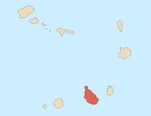
Santiago is located between the islands of Maio (40 km west) and Fogo (50 km east) and is one of the Sotavento. It was the first of the islands to be settled, the town of Cidade Velha being founded as Riberia Grande in 1462. It is also home to the nation's capital city of Praia and to one of the islands’ four international airports, Praia International Airport, 3 km from the capital (IATA airport code: RAI, Praia).
Etymology
In the 19th century it was called St. Jago.[2]
History


The island was discovered by António da Noli in around 1460 who built a garrison in Cidade Velha which was then known as Ribeira Grande. Transcontinental slavery made Cidade Velha the second richest city in the Portuguese realm. Later, Portugal faced competition by the English, Dutch, French and Spanish who gradually took over the slave trade. In 1712, the capital no longer served Cidade Velha which was attacked by pirates and was moved to the Praia plateau. The island population were disadvantaged by the Portuguese colonial system and supported Amílcar Cabral and the African Party for the Independence of Guinea and Cape Verde and the independence of 1975. Santiago several times hosted conferences on Creole culture.
Geography
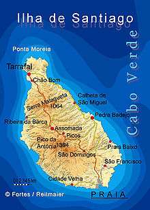
Santiago is the largest island of Cape Verde, with an area of 991 km². The island is mountainous, although slightly flatter in the southeast. The wetter climate of the interior and the eastern coast contrasts with the drier one in the south/southwest coast. Praia, located in the southeast coast, is the largest city on the island, and also the largest city and capital of the country. Other towns on the island include Cidade Velha, 15 km west of Praia, Cape Verde's first capital; Assomada, 60 km north and Tarrafal in the northern part of the island 75 km from the capital.
The Cape Verde islands are a very degradated area. Due to their proximity to the Sahara, most of the Cape Verde islands are dry, but on islands with high mountains and farther away from the coast, by orography, the humidity is much higher, giving a rainforest habitat, very degraded by the strong human presence. Northeastern slopes of high mountains often receive a lot of rain and Southwest slopes not. These umbria areas are identified with cool and moisture. Some islands, as Santiago with steep mountains, are covered with vegetation where the dense moisture condense and soak the plants, rocks, soil, logs, moss etc.
Cloud forests developed about mountains, where the dense moisture from the sea or ocean, is precipitated by the action of the relief. Opposing the terrain to a front of warm, moist air mass, it forces to increase the height above sea level of that body wet and warm air mass, which cools and decreases the dew point, causing it to condense part of the moisture that falls as rain or fog, creating a habitat especially cool, saturated with moisture in the air and soil.
Population
As of 1830, Santiago's population was estimated at 24,000.[2] Santiago has always been the most populous island in Cape Verde. The island population has doubled since the independence of Cape Verde in 1975. The 2010 census population of the island was 272,312.
Economy
The main industries are agriculture, tourism, fishing and others, and leastly manufacturing. Main agricultural products are corn, sugar cane, banana, coffee and mangoes.
Sports
The island are divided into two zones, the North and the South Zones and has football (soccer), basketball and volleyball competitions. Until 2003, the island had one island championships, the Santiago Island Championships
Notable residents
- Jorge Barbosa – writer
- Arménio Vieira – writer
- António Mascarenhas Monteiro – former President
- José Maria Neves – present Prime Minister
- Joaquim Manuel Andrade (Dr. Azágua) - académico, poeta, kriolista
- Manuel Veiga - académico, linguista, kriolista
- Carlos Alberto Martins (Katchás) – musician
- Orlando Monteiro Barreto (Orlando Pantera) – musician
References
- ↑ Portal do Instituto Nacional de Estatística: INE - CENSO 2010
- 1 2 Roberts, Edmund (1837). Embassy to the Eastern Courts of Cochin-China, Siam, and Muscat. New York: Harper & Brothers. p. 17.
External links
| Wikimedia Commons has media related to Santiago (Cape Verde). |
- GTM - Santiago (Portuguese)
- http://www.genk.com/033 (Dutch)
| ||||||||||||||||