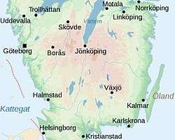
South Swedish highlands

The South Swedish highlands (Swedish: Sydsvenska höglandet) is a hilly area covering large parts of Götaland in the southern parts of Sweden. Except for a lack of deep valleys the landscape is similar to the Norrland terrain found further north in Sweden.[1]
Much of the highlands lies above 200 m.a.s.l. and there are large areas around the highlands that exceed 100 m.a.s.l. The highlands are centered on Småland but cover also large swathes of Skåne, Halland, Västergötland, Östergötland and Blekinge.[2] The highest point lies 377 m.a.s.l.[3]
Within a geological context the highlands are the expression of the South Swedish Dome.[3] During the last deglaciation of the Weichselian Ice Sheet the South Swedish highlands were a place of ice flow divergence.[4]
See also

References
- ↑ Lundqvist, Magnus; Lundqvist, Jan; Rystedt, Gunnar; Malmer, Nils; Ulfstrand, Staffan; Behrens, Sven; Fries, Jöran; Larsson, Erik; Segnestam, Mats; Landell, Nils-Erik; Persson, Göran; Rosén, Bo (1969). "Landskapet". Det Moderna Sverige (in Swedish). Bonniers. pp. 64–67.
- ↑ Åkerhielm, Erik (1912). "Sydsvenska höglandet". Geografien i skildingar och bilder (in Swedish). Lund. p. 49–90. Retrieved June 7, 2015.
- 1 2 Lidmar-Bergström, Karna; Bonow, Johan M.; Japsen, Peter (2013). "Stratigraphic Landscape Analysis and geomorphological paradigms: Scandinavia as an example of Phanerozoic uplift and subsidence". Global and Planetary Change 100: 153–171.
- ↑ Lundqvist, Jan; Lundqvist, Thomas; Lindström, Maurits; Calner, Mikael; Sivhed, Ulf (2011). "Svekokarelska Provinsen". Sveriges Geologi: Från urtid till nutid (in Swedish) (3rd ed.). Spain: Studentlitteratur. p. 515. ISBN 978-91-44-05847-4.
Coordinates: 56°59′00″N 14°33′00″E / 56.9833°N 14.5500°E