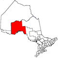
Unorganized Thunder Bay District
| Unorganized Thunder Bay | |
|---|---|
| Unorganized area | |
| Thunder Bay, Unorganized | |
|
Sleeping Giant Provincial Park | |
 Unorganized Thunder Bay | |
| Coordinates: 50°00′N 88°00′W / 50.000°N 88.000°WCoordinates: 50°00′N 88°00′W / 50.000°N 88.000°W | |
| Country |
|
| Province |
|
| District | Thunder Bay |
| Government | |
| • Federal riding |
Algoma—Manitoulin—Kapuskasing Kenora Thunder Bay—Rainy River Thunder Bay—Superior North |
| • Prov. riding |
Algoma—Manitoulin Kenora—Rainy River Thunder Bay—Atikokan Thunder Bay—Superior North |
| Area[1] | |
| • Land | 97,007.34 km2 (37,454.74 sq mi) |
| Population (2011)[1] | |
| • Total | 5,909 |
| • Density | 0.1/km2 (0.3/sq mi) |
| Time zone | EST (UTC-5) |
| • Summer (DST) | EDT (UTC-4) |
| Postal Code FSA | P0T |
| Area code(s) | 807 |
Unorganized Thunder Bay District is an unorganized area in northwestern Ontario, Canada in Thunder Bay District. It comprises all parts of the district that are not part of an incorporated municipality or a First Nations reserve.
Most of the territory is within the Eastern Time Zone, but the part west of the 90th meridian is in the Central Time Zone.
Local service boards
Other communities
- Auden
- Burchell Lake
- Collins
- English River (on boundary with Kenora District)
- Finmark
- Flindt Landing
- Harvey
- Hemlo
- Kashabowie
- Nolalu
- Ombabika
- Pays Plat
- Raith
- Savant Lake
- Shabaqua
- Shabaqua Corners
- Silver Islet
- Silver Mountain
- Staunton
- Sorrell Lake
- Suomi
- Upsala
Demographics
| |||||||||||||||||||
Population trend:[5]
- Population in 2011: 5909
- Population in 2006: 6585
- Population in 2001: 6223
- Population in 1996: 8460 (or 6534 when adjusted to 2001 boundaries)
- Land area: 105,454.69 square kilometres (40,716.28 sq mi)
- Population in 1991: 8168
Parks in Unorganized Thunder Bay
Provincial parks in Unorganized Thunder Bay include:
- Albany River Provincial Park
- Kopka River Provincial Park
- Neys Provincial Park
- Rainbow Falls Provincial Park
- Sleeping Giant Provincial Park
- Steel River Provincial Park
- Wabakimi Provincial Park
It is also home to one National Park of Canada: Pukaskwa National Park.
See also
References
- 1 2 "Thunder Bay, Unorganized census profile". 2011 Census of Population. Statistics Canada. Retrieved 2012-02-10.
- ↑ "2011 Community Profiles". Canada 2011 Census. Statistics Canada. July 5, 2013. Retrieved 2012-02-10.
- ↑ "2006 Community Profiles". Canada 2006 Census. Statistics Canada. March 30, 2011. Retrieved 2011-04-18.
- ↑ "2001 Community Profiles". Canada 2001 Census. Statistics Canada. February 17, 2012. Retrieved 2011-04-18.
- ↑ Statistics Canada: 1996, 2001, 2006 census
| |||||||||||||||||||||||||||||||||||||||||


