Seogwipo
Coordinates: 33°15′10″N 126°33′40″E / 33.252816°N 126.561123°E
| Seogwipo 서귀포시 | ||
|---|---|---|
| Administrative city | ||
| Korean transcription(s) | ||
| • Hangul | 서귀포시 | |
| • Hanja | 西歸浦市 | |
| • Revised Romanization | Seogwipo-si | |
| • McCune-Reischauer | Sŏgwip'o-si | |
|
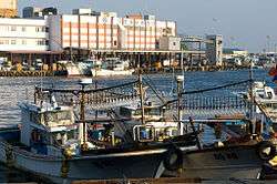
Seogwipo Harbor | ||
| ||
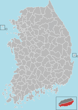
 Location in South Korea | ||
| Country |
| |
| Region | Jeju | |
| Administrative divisions | 12 dong, 3 eup, 2 myeon | |
| Area | ||
| • Total | 870.68 km2 (336.17 sq mi) | |
| Population (December 31, 2011) | ||
| • Total | 155,691 | |
| • Density | 178.82/km2 (463.1/sq mi) | |
| • Dialect | Jeju | |
| Website |
www | |
Seogwipo (Korean pronunciation: [sʰʌɡɥipʰo]) is a city in Jeju Province, South Korea with population of 155,691 as of December 31, 2011. In July, 2006, Seogwipo city was expanded to include the entire southern half of Jeju island. In 2002, it was one of the host cities for the FIFA World Cup. As one of the World Heritages by UNESCO, it has huge potential to be developed in the third industries including travel. Total budget in 2012 is reported to be KRW 524.6 billion

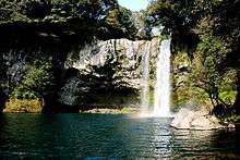
Jeongbang Waterfall

Cheonjiyeon Waterfall
Climate
| Climate data for Seogwipo (1981–2010) | |||||||||||||
|---|---|---|---|---|---|---|---|---|---|---|---|---|---|
| Month | Jan | Feb | Mar | Apr | May | Jun | Jul | Aug | Sep | Oct | Nov | Dec | Year |
| Average high °C (°F) | 10.7 (51.3) |
11.6 (52.9) |
14.4 (57.9) |
18.5 (65.3) |
22.0 (71.6) |
24.6 (76.3) |
28.3 (82.9) |
30.1 (86.2) |
27.4 (81.3) |
23.4 (74.1) |
18.2 (64.8) |
13.2 (55.8) |
20.2 (68.4) |
| Daily mean °C (°F) | 6.8 (44.2) |
7.8 (46) |
10.6 (51.1) |
14.8 (58.6) |
18.6 (65.5) |
21.7 (71.1) |
25.6 (78.1) |
27.1 (80.8) |
23.9 (75) |
19.3 (66.7) |
14.1 (57.4) |
9.3 (48.7) |
16.6 (61.9) |
| Average low °C (°F) | 3.6 (38.5) |
4.4 (39.9) |
7.1 (44.8) |
11.3 (52.3) |
15.3 (59.5) |
19.2 (66.6) |
23.5 (74.3) |
24.6 (76.3) |
21.1 (70) |
15.9 (60.6) |
10.6 (51.1) |
5.9 (42.6) |
13.5 (56.3) |
| Average precipitation mm (inches) | 61.0 (2.402) |
77.1 (3.035) |
131.2 (5.165) |
174.9 (6.886) |
205.8 (8.102) |
276.9 (10.902) |
309.8 (12.197) |
291.6 (11.48) |
196.6 (7.74) |
81.6 (3.213) |
71.4 (2.811) |
45.1 (1.776) |
1,923 (75.709) |
| Average precipitation days (≥ 0.1 mm) | 10.3 | 9.5 | 11.0 | 10.5 | 10.7 | 12.9 | 14.3 | 14.2 | 10.3 | 6.1 | 7.4 | 8.1 | 125.3 |
| Average relative humidity (%) | 62.8 | 62.1 | 62.4 | 64.5 | 69.9 | 78.2 | 84.1 | 79.0 | 72.5 | 63.9 | 63.2 | 62.2 | 68.7 |
| Mean monthly sunshine hours | 152.2 | 152.6 | 174.0 | 190.9 | 199.0 | 144.2 | 142.1 | 184.2 | 176.1 | 207.1 | 170.5 | 161.8 | 2,054.7 |
| Source: Korea Meteorological Administration[1] | |||||||||||||
Sister cities
 – Kashima, Ibaraki, Japan (since November 2003).[2]
See also
- List of cities in South Korea
- Branksome Hall Asia, a school located in Seogwipo.
References
- ↑ "평년값자료(1981–2010)". Korea Meteorological Administration. Retrieved 2011-05-01.
- ↑ "Status of Jeju Special Self-Governing Province Sister City". Island of World Peace, Jeju. Jeju Self-Governing Province. December 2009. Retrieved 7 December 2015.
External links
| Wikivoyage has a travel guide for Seogwipo. |
| |||||||||||||||||
| ||||||||||||||||||||||||||||||||||
This article is issued from Wikipedia - version of the Wednesday, February 10, 2016. The text is available under the Creative Commons Attribution/Share Alike but additional terms may apply for the media files.


