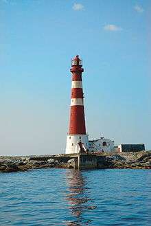
Sletringen Lighthouse
 View of lighthouse | |
 | |
| Location | Sør-Trøndelag, Norway |
|---|---|
| Coordinates | 63°39′58″N 08°15′44″E / 63.66611°N 8.26222°ECoordinates: 63°39′58″N 08°15′44″E / 63.66611°N 8.26222°E |
| Year first constructed | 1899 |
| Year first lit | 1899 |
| Automated | 1993 |
| Deactivated | 2008 |
| Construction | Cast iron |
| Tower shape | Round |
| Markings / pattern | Red tower with two white stripes |
| Height | 46 metres (151 ft) |
| Focal height | 49 metres (161 ft) |
| Intensity | 2,700,000 candela |
| Range | 18.5 nmi (34.3 km; 21.3 mi) |
| Characteristic | Fl (2) W 15s |
Sletringen Lighthouse (Norwegian: Sletringen fyr) is a lighthouse just off coast of Titran in the municipality of Frøya in Sør-Trøndelag county, Norway. It is Norway's tallest lighthouse. The lighthouse has a secondary light also. The main light is a flashing white light with a two blink pattern and it can be seen for 18 nautical miles (33 km; 21 mi). The secondary light is a white isophase light that can be seen for 14.6 nautical miles (27.0 km; 16.8 mi)[1]
The lighthouse is lit from July 21 until May 16 each year. It is not lit during the summer due to the midnight sun in Norway. The lighthouse is also equipped with a foghorn.[2]
The lighthouse lost power in 2008, and the power supply has not been restored.[3]
References
- ↑ Kystverket (2008). Norske Fyrliste 2008 (PDF) (in Norwegian). ISBN 978-82-450-0628-5.
- ↑ Store norske leksikon. "Sletringen fyr" (in Norwegian). Retrieved 2010-12-22.
- ↑ Aamodt, Torill (21 August 2008). "Nord-Europas høyeste fyr mistet strømforsyningen for et halvt år siden" (in Norwegian). NRK.
This article is issued from Wikipedia - version of the Sunday, October 11, 2015. The text is available under the Creative Commons Attribution/Share Alike but additional terms may apply for the media files.