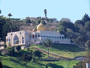
Sikh Center of San Francisco Bay Area

The Sikh Center of San Francisco Bay Area (also known as Gurdwara Sahib of El Sobrante) is a Sikh gurdwara in the hills of unincorporated El Sobrante, California, in the East Bay of the San Francisco Bay Area.[1]
Overview
The Center was established in May 1979.[1]
The Center features large golden domes atop a pink-cream-beige tiled box arched structure. Regular services are held every Wednesday and Sunday.[1] The site is open to drop in visitors from 5AM to 9PM.[2] Langar, collective eating while sitting on floor, is given every day, free of cost, to all visitors, Sikh or non-Sikh.[2] Visitors must cover their hair, be sober and have no drugs, alcohol, or tobacco products in their possession, and must enter barefoot after washing their feet.[2]
Shooting incident
On January 23, 2000 a gunman, Joga Singh Sandher,[3] opened fire with an assault weapon onto temple leader, local teacher, and human rights activist Ajmer Singh Malhi, killing him and seriously injuring another worshipper before being subdued by bystanders.[4][5][6]
Notable members
One of the center's adherents is Harpreet Sandhu, a politician and activist. He is a former president of the organization as well and helped the community deal with the tragedy that occurred here.
See also
References
- 1 2 3 My Gurdwara, Gurdwara Sahib website, access date 20-02-2009
- 1 2 3 Visiting Sikh Temple, Gurdwara Shaib website, access date 20-02-2009
- ↑ San Lorenzo man given 50-to-life sentence in Sikh leader's killing / Limo driver shot math teacher in temple by Henry Lee San Francisco Chronicle, 11-09-2001, access date 8-05-2012
- ↑ Temple shooting at odds with Sikh beliefs, by John Boudreau, Contra Costa Times, 30-01-2000, access date 20-02-2009
- ↑ Farewell to slain teacher and Sikh leader, by Shawn Masten, Contra Costa Times, 29-01-2000, access date 20-02-2009
- ↑ Fatal Shooting at Sikh Temple by Henry Lee San Francisco Chronicle, 24-01-2000, access date 31-08-2011
External links
37°57′35″N 122°19′00″W / 37.9597°N 122.3168°WCoordinates: 37°57′35″N 122°19′00″W / 37.9597°N 122.3168°W