Sierra Arana
| Sierra Arana | |
|---|---|
| Sierra Harana | |
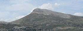
 Peña de la Cruz, the highest peak in the Sierra Arana | |
| Highest point | |
| Peak | Peña de la Cruz |
| Elevation | 2,027 m (6,650 ft) |
| Dimensions | |
| Length | 510 km (320 mi) |
| Width | 60 km (37 mi) |
| Geography | |
| Country | Spain |
| Range coordinates | 37°20′00″N 3°30′00″W / 37.3333°N 3.5°WCoordinates: 37°20′00″N 3°30′00″W / 37.3333°N 3.5°W |
| Parent range | Subbaetic System |
| Geology | |
| Orogeny | Alpine orogeny |
| Age of rock | Cenozoic |
| Type of rock | Limestone |
The Sierra Arana or Sierra de Arana, also known as Sierra Harana, is a mountain range in the center of the province of Granada, southern Spain. Its highest peak is the Peña de la Cruz, at 2,027 m (6,650 ft).
Description
It is a mostly karstic range,[1] part of the larger Subbaetic System. According to some geographers Sierra Arana includes other ranges such as the Sierra de Cogollos, the Sierra de la Yedra and the Sierra de Alfacar y Víznar.
Municipalities which are part of the Sierra Arana include Deifontes, Iznalloz, Cogollos Vega, Huétor Santillán, Diezma, Darro, La Peza, Píñar, Morelábor and Huélago. The area of the range is bounded in the north by the Comarca of Los Montes and its southern end is included in the area of the Sierra de Huétor and la Alfaguara Natural Park.[2]
