Sichon District
| Sichon สิชล | |
|---|---|
| Amphoe | |
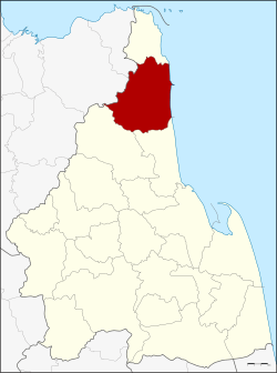
 Amphoe location in Nakhon Si Thammarat Province | |
| Coordinates: 9°0′24″N 99°54′6″E / 9.00667°N 99.90167°ECoordinates: 9°0′24″N 99°54′6″E / 9.00667°N 99.90167°E | |
| Country |
|
| Province | Nakhon Si Thammarat |
| Seat | Thung Prang |
| Area | |
| • Total | 703.1 km2 (271.5 sq mi) |
| Population (2005) | |
| • Total | 83,981 |
| • Density | 119.4/km2 (309/sq mi) |
| Time zone | ICT (UTC+7) |
| Postal code | 80120 |
| Geocode | 8014 |
Sichon (Thai: สิชล) is a district (amphoe) of Nakhon Si Thammarat Province, southern Thailand.
Geography
The district is in the northern part of the province. Neighboring districts are (from the south clockwise) Tha Sala and Nopphitam of Nakhon Si Thammarat Province, Kanchanadit and Don Sak of Surat Thani Province, and Khanom of Nakhon Si Thammarat again. To the east is the Gulf of Thailand.
Namtok Si Khit National Park is in the district.[1]
In Sao Phao sub-district there is an approximately 1,500-year-old Hindu temple.
Administration
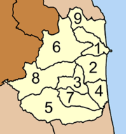
The district is divided into nine sub-districts (tambon), which are further subdivided into 106 villages (muban). Sichon itself has township (thesaban tambon) status and covers part of tambon Khanom. There are further nine tambon administrative organizations.
|
 |
References
- ↑ "Namtok Si Khit National Park". Department of National Parks (DNP) Thailand. Retrieved 4 November 2015.