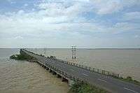
Sriharikota
| Sriharikota శ్రీహరికోట श्रीहरिकोटा | |
|---|---|
| town | |
 Sriharikota | |
| Coordinates: 13°43′04″N 80°12′00″E / 13.7178°N 80.2000°ECoordinates: 13°43′04″N 80°12′00″E / 13.7178°N 80.2000°E | |
| Country | India |
| State | Andhra Pradesh |
| District | Nellore District |
| Languages | |
| • Official | Telugu |
| Time zone | IST (UTC+5:30) |
| PIN | 524124 |
| Vehicle registration | AP |
| Climate | tropical wet and dry (Köppen) |
Sriharikota is a barrier island off the Bay of Bengal coast located in the Indian state of Andhra Pradesh, India. It houses the Satish Dhawan Space Centre, one of the two satellite launch centers in India with the other being the Thumba Equatorial Rocket Launching Station in Thiruvananthapuram. Indian Space Research Organisation launch satellites using multistage rockets such as the Polar Satellite Launch Vehicle and the Geosynchronous Satellite Launch Vehicle from Sriharikota.[1]
Location
Sriharikota is located in Nellore district in Andhra Pradesh and separates Pulicat Lake from the Bay of Bengal[2] The nearest town and railway station is Sullurpeta.[3]
Climate
The climate of Sriharikota is tropical wet and dry (Aw; bordering on As) in the Köppen–Geiger climate classification system.
| Climate data for Sriharikota | |||||||||||||
|---|---|---|---|---|---|---|---|---|---|---|---|---|---|
| Month | Jan | Feb | Mar | Apr | May | Jun | Jul | Aug | Sep | Oct | Nov | Dec | Year |
| Average high °C (°F) | 29.6 (85.3) |
31.5 (88.7) |
33.6 (92.5) |
36 (97) |
38.8 (101.8) |
38 (100) |
35.6 (96.1) |
35.2 (95.4) |
34.5 (94.1) |
32.3 (90.1) |
29.6 (85.3) |
28.8 (83.8) |
33.63 (92.51) |
| Daily mean °C (°F) | 24.6 (76.3) |
26 (79) |
28.1 (82.6) |
30.9 (87.6) |
33.4 (92.1) |
32.8 (91) |
31 (88) |
30.7 (87.3) |
30 (86) |
28.3 (82.9) |
26 (79) |
24.6 (76.3) |
28.87 (84.01) |
| Average low °C (°F) | 19.7 (67.5) |
20.6 (69.1) |
22.7 (72.9) |
25.8 (78.4) |
28 (82) |
27.7 (81.9) |
26.5 (79.7) |
26.2 (79.2) |
25.6 (78.1) |
24.4 (75.9) |
22.4 (72.3) |
20.2 (68.4) |
24.15 (75.45) |
| Average precipitation mm (inches) | 13 (0.51) |
3 (0.12) |
2 (0.08) |
15 (0.59) |
58 (2.28) |
49 (1.93) |
101 (3.98) |
127 (5) |
95 (3.74) |
253 (9.96) |
287 (11.3) |
109 (4.29) |
1,112 (43.78) |
| Source: Climate-Data.org, altitude: 1m[4] | |||||||||||||
References

- ↑ Srīharikota Island. (2011). In Encyclopædia Britannica. Retrieved from Encyclopædia Britannica. Encyclopædia Britannica Online.
- ↑ Pincode and Map Location of SRIHARIKOTA RANGE, NELLORE District, ANDHRA PRADESH State-Source Pincode locator
- ↑ Driving Directions from Sriharikota to Sullurpeta-Source-Google Maps
- ↑ "Climate: Sriharikota - Climate graph, Temperature graph, Climate table". Climate-Data.org. Retrieved 31 October 2013.
External links
| Wikivoyage has a travel guide for Sriharikota. |
| Wikimedia Commons has media related to Sriharikota. |