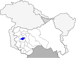
Shopian district
| Shopian district शोपियां ज़िला / شوپیاں ضلع | |
|---|---|
| District | |
 Location in Jammu and Kashmir, India | |
| Coordinates: 33°43′00″N 74°50′00″E / 33.7167°N 74.8333°ECoordinates: 33°43′00″N 74°50′00″E / 33.7167°N 74.8333°E | |
| Country |
|
| State | Jammu and Kashmir |
| Headquarters | Shopian |
| Languages | |
| • Official | Urdu |
| Time zone | IST (UTC+5:30) |
| Website | http://shopian.nic.in |
The Shopian District is one of the districts of Jammu and Kashmir, India. Its headquarters is located in Shupiyan.
Demographics
According to the 2011 census, the Shopian district has a population of 265,960,[1] roughly equal to that of the nation of Barbados.[2] This gives the Shopian district a ranking of 577th in India (out of a total of 640).[1] The district has a population density of 852 inhabitants per square kilometre (2,210/sq mi) .[1] Its population growth rate over the 2001–2011 decade was 25.85%.[1] Shopian has a sex ratio of 951 females for every 1000 males,[1] and a literacy rate of 62.49%.[1]
Education
- Colleges
- Degree College for Boys and Girls (Science & Arts streams)
- University of Siraj Ul Uloom Imamsaheb
- Losetech Computer Education, Shopian
- Govt. Polytechnic college Alyalpora Shopian.
- RPC Computers Srinagar Road Shopian.
- Schools
- Gousia Hanfia institute TRENZ.
- Brilliant Public High School, Mullo Dangerpora
- Public Model School, Ratnipora
- Eternal Success School, Shopian
- Geographicus Public School, Shopian
- National Innovations Public School, Zainapora, Shopian
- Mohammadiya Institution near Eid Gah
- Shah-i-Hamdan School Batapora, on the banks of Ranbi-Ara
- Green Land Higher Secondary Edu. Inst. near the fire station
- Maktabia Islamia School, near the police station
- Sky Lark Public School, near the CEO building batpora spn
- Spring Dales Public School Batapora, near Phe division
- Shama Public High School Habdipora shopian
- Lords Token School Lawahind ganowpora spn
- Activity Public School, Nowpora
- Govt. Middle School, Manzimpora
- School Chale Hum School Village, Manzimpora
- Govt High School, Reshinagri
- Talimul Isalm Ahmadiyya Public School, Reashinager
- Govt Boys Primary School, Reashinager
- Govt Girls Primary School, Reashinager
- Darul Uloom Islamia, Pinjura
- University of Siraj-ul-Uloom, Imamsaheb
- Govt. Boys & Girls Higher Secondary, Shopian
- Sun Shine Public School, Pinjura
- Ameer Kabeer Memorial Institute K. Manloo, Shopian
- Govt. High School, Pinjura
- Shah I Hamdan Institute, Ramnagri
- Govt.High School, Ramnagri
- Govt. High School, D. K. Pora
- Govt. H.S.S., Kapren
- Simnania Public School, Arshi Pora, Shopian
- JK Charitable Welfare Trust
- Al-Mustafa Educational Trust, Mashwara
- Govt. Middle School, Mashwara
- Govt. Middle School, Reshipora, Zainapora, Shopian
- Central Public hr.sec. School, Chitragam
- Govt. Higher Secondary School, Zainapora
- Govt. Boys Middle School, Zainapora
- Govt. Girls Middle School, Zainapora
- Motherland Public School, Zainapora
- Garieb Nawaz Public School, Zainapora
- Hanfiya Middle School, Zainapora
- Haji Mumin Higher Secondary, Hajipora
- Hanfia Institute High School, Losdanow
- Hamdania High School, Wachi.
- Govt. High school, Wachi.
- Alsaba educational Institute, Wachi.
Healthcare
The district has a number of hospitals and healthcare facilities, some of which include: District Hospital, Shopian, Sub District Hospital Keller Sub District Hospital Zanapora, PHC Herman, PHC Pinjura PHC DK Pora, PHC Vehil, PHC Sedow.
Places of interest
Shopian district has many places with tourism potential: the waterfalls of Aharbhal, Kounsernag, Kongiwatan, Arshi Pora Lahanthour, Sedow, Herpora Wild Life Sanctuary, Dabjan - 6 km from Heerpora Village; Peer Marg/Peer Gali - 20 km away from Heerpora on the historical Mughal Road; beautiful Lake Nandansar - 2 km away from the Peer Ki Gali; Hash Wang Bagam Pather, Sok Saray,and Mughal Saray at Jajinar. The Jamia Masjid in Shopian is one of the famous historical monuments built during the Mughal reign resembling that of jamia Masjid Srinagar. The famous Aasar-i-Sharief Dargah at Pinjura, attracts thousands of devotees on the occasion of Eid-i-Milad-un- Nabi and Shab-i-Mehraj. Darul Uloom Islamia Pinjura where large people gather to seek (spiritual and moral) knowledge and propagate to others.
Transport
The major roads connecting Shopian with neighbouring districts are:
- Shopian-Pulwama-Srinagar Road
- Shopian-Anantnag Via Zainapora
- Shopain -Anantnag via Kaider
- Shopain Anantnag Via Kulgam kudwani Wanpoh khanabal
- Shopian-Rajori-Poonch via Mughal Road
- Shopian-Zawoora-Keller
- Shopian-Sedow-Aharbal
- Shopian-Heerpora
- Shopian-Bijbehara via Imamsahib, d k pora kulgam Dachoo, Nagbal
- Shopian-Pinjoora
- Shopian-Tarkiwangam
- Shopain-Zainapora( Babapora)- Frisal- khudwani
- Shopain-Zainapora( Babapora)- wachi - Sangam
- Shopian to Kulgam kachdoora, sehpora Mohanpor or Okay
- Shopian to Reshinagri via Narwaw, Saidpora
- Shopian to Nehama via Vehil Nowgam, Kanjiullar
- Shopian to Ramnagri via Narwaw, Saidpora, Amshipora.
- Shopain to Kangiullar via Ramnagri and Gadiporahir
- Shopain to Kheer Bhawani at Mamzam via Ramnagri, Kanjiuller Nihama
- Shopain to(Aharbal)via Ramnagri, Gadipora and Nihama
- Shopian to Zawoora via Rambiara.
- Shopian to Shadab Karewa Via Zowoora.
- Shopian to Narapora, keller via Zawoora
- Shopain to Ahrabal via Saidow
- Shopian Arshi pora road to link Via Herman Kadder Road
- Shopian to Manzimpara via Kumdalan.
References
- 1 2 3 4 5 6 "District Census 2011". Census2011.co.in. 2011. Retrieved 2011-09-30.
- ↑ US Directorate of Intelligence. "Country Comparison:Population". Retrieved 2011-10-01.
Barbados 286,705 July 2011 est.
line feed character in|quote=at position 9 (help)
External links
 |
Badgam district | Pulwama district |  | |
| |
||||
| ||||
| | ||||
| Kulgam district |