Shiptonthorpe
Coordinates: 53°52′46″N 0°42′19″W / 53.879312°N 0.705303°W
Shiptonthorpe is a village and civil parish in the East Riding of Yorkshire, England. It is situated approximately 5 miles (8 km) south-east of the market town of Pocklington and 2 miles (3.2 km) north-west of the market town of Market Weighton. It lies on the north side of the A1079 road.

According to the 2011 UK census, Shiptonthorpe parish had a population of 503,[1] an increase on the 2001 UK census figure of 419.[2]
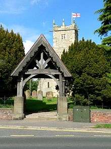
In Shiptonthorpe there are two pubs, (one currently closed) a petrol station, two Churches, a shop, and a Renault main dealer. The parish church of All Saints is a Grade I listed building.[3] On the outskiirts of the village there is a garden centre called Langlands, and a McDonald's (formerly a Little Chef) which opened in 2014.
Shiptonthorpe was served by Londesborough railway station on the York to Beverley Line between 1847 and 1965.[4]
References
- 1 2 "Key Figures for 2011 Census: Key Statistics: Area: Shipton Thorpe CP (Parish)". Neighbourhood Statistics. Office for National Statistics. Retrieved 6 February 2013.
- ↑ "2001 Census: Key Statistics: Parish Headcounts: Area: Shipton Thorpe CP (Parish)". Neighbourhood Statistics. Office for National Statistics. Retrieved 20 May 2008.
- ↑ Historic England. "Church of All Saints (1310431)". National Heritage List for England. Retrieved 6 February 2013.
- ↑ Butt, R. V. J. (1995). The Directory of Railway Stations: details every public and private passenger station, halt, platform and stopping place, past and present (1st ed.). Sparkford: Patrick Stephens Ltd. ISBN 1-8526-0508-1. OCLC 60251199.
- Gazetteer — A–Z of Towns Villages and Hamlets. East Riding of Yorkshire Council. 2006. p. 10.
External links
| Wikimedia Commons has media related to Shiptonthorpe. |
- Historic England. "Details from image database (167085)". Images of England.
- Shiptonthorpe in the Domesday Book
| ||||||||||||||||||||||||||
