Shimla district
| Shimla district ज़िला शिमला | |
|---|---|
| District | |
| Nickname(s): The Queen of Hills | |
 | |
 Shimla district Location in Himachal Pradesh, India | |
| Coordinates: 31°6′12″N 77°10′20″E / 31.10333°N 77.17222°ECoordinates: 31°6′12″N 77°10′20″E / 31.10333°N 77.17222°E | |
| Country |
|
| State | Himachal Pradesh |
| Headquarters | Shimla |
| Government | |
| • Deputy Commissioner | Onkar Sharma, IAS |
| • Superintendent of Police | Sonal Agnihotri,IPS |
| • Lok Sabha Constituencies | Shimla |
| • Vidhan. Sabha Constituencies | |
| Area | |
| • Total | 5,131 km2 (1,981 sq mi) |
| Population (2011) | |
| • Total | 813,384 |
| • Rank | 3rd |
| • Density | 160/km2 (410/sq mi) |
| Languages | |
| • Official | Hindi |
| Demographics | |
| • Sex ratio | 916 |
| • Literacy | 84.55 |
| • Literacy: male | 90.73 |
| • Literacy: female | 77.80 |
| Time zone | IST (UTC+5:30) |
| Area code(s) | 91 177 xxxxxxx |
| ISO 3166 code | IN-HP |
| Largest city | Shimla |
| Climate | ETh (Köppen) |
| Precipitation | 1,520 millimetres (60 in) |
| Avg. annual temperature | 17 °C (63 °F) |
| Avg. summer temperature | 22 °C (72 °F) |
| Avg. winter temperature | 4 °C (39 °F) |
| Website |
hpshimla |
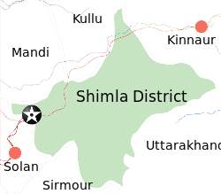
Shimla district of Himachal Pradesh lies between the longitude 77.00" and 78.19" east and latitude 30.45" and 31.44" north, having its headquarters in Shimla. It is surrounded by Mandi and Kullu in the north, Kinnaur in the east, Uttarakhand in the southeast, Solan to the southwest and Sirmaur in the south. The elevation of the district ranges from 300 metres (984 ft) to 6,000 metres (19,685 ft).
As of 2011 it is the third most populous district of Himachal Pradesh (out of 12), after Kangra and Mandi.[1] It is the most urbanized district of Himachal Pradesh.
The most commonly practised religion in the district is Hinduism. Hindi and Pahari are the languages spoken. Tourism and agriculture/horticulture are the majors source of income.
Administrative structure
| Sl. No. | Particulars | Description |
|---|---|---|
| 1 | Geographical Area | 5,131 km2 |
| 2 | Area (out of total area) of H.P. | 9.22% |
| 3 | Tehsils | (12) Rampur, Kumarsain, Sunni, Shimla(R), Shimla(U), Theog-panoli, Chaupal, Jubbal, Kotkhai, Rohru, Chirgaon, Dodra Kawar |
| 4 | Sub-Tehsils | (5) Nankhari Rampur, Junga Shimla (R), Cheta(Kupvi) Chaupal, Nerwa Chaupal, Tikar Rohru |
| 5 | Towns | (10) Rampur, Narkanda, Seoni, Kumarsain, Shimla, Theog, Chaupal, Kotkhai, Jubbal, Rohru |
| 6 | Sub-Divisions | (7) Shimla(U), Shimla(R), Theog, Chaupal, Rohru, Rampur, Dodra Kawar |
| 7 | C.D. Blocks | (10) Mashobra, Theog, Chaupal, Jubbal, Kotkhai, Rohru, Kumarsain, Chirgaon, Basantpur, Nankhari |
| 8 | Legislative Assembly | (8) Rampur, Shimla(R), Shimla(U), Theog, Chaupal, Jubbal - Kotkhai, Rohru, Kasumpati |
| 9 | Villages | 2,914 |
| 10 | Inhabited | 2,520 |
| 11 | Uninhabited | 394 |
| 12 | Density | 159 person per km2 |
| 13 | Panchayts | 363 |
Access

By road
Shimla is connected by road to all the major towns. Distance between the major towns and Shimla:
- Kalka - 80 km
- Patiala - 172 km
- Chandigarh - 119 km
- Ambala - 166 km
- Delhi - 380 km
- Agra - 568 km
- Amritsar - 342 km
- Jammu (via Pathankot) - 482 km
- Chaupal - 100 km
- Srinagar - 787 km
- Jaipur - 629 km
- Dharmsala (via Mandi) - 290 km
- Dharamsala (via Hamirpur) - 235 km
- Dalhousie - 345 km
- Chamba - 401 km
- Kullu - 235 km
- Manali - 280 km
- Mandi - 153 km
- Palampur - 270 km
- Rohru - 129 km
- Dehradoon - 275 km
- Theog - 28 km
- Rampur - 132 km
District profile


Population
As of Census of India 2001[2]
- Persons - 8,13,384
- Males - 4,24,486
- Females - 3,88,898
- Sex ratio (females per 1000 males) - 916
- Growth (2001–2011) - 12.58%
- Rural - 555,269
- Urban - 167,233
- Scheduled Caste population - 188,787
- Percentage to total population - 26.13%
- Scheduled Tribe population - 4,112
- Percentage to total population - 0.57%
- Number of households - 1 54,693
- Household size (per household) - 5
Literacy and education levels
- Literates
- Persons - 6,19,427
- Males - 3,47,013
- Females - 2,72,414
- Literacy rate
- Persons - 84.55 %
- Males - 90.73 %
- Females - 77.80%
Education level attained
Total - 504,330
- Without level - 11,640
- Below primary - 97,060
- Primary - 114,805
- Middle - 78,995
- Matric/Higher Secondary/Diploma - 153,284
- Graduate and above - 48,464
Age groups
- 0 – 4 years - 59,305
- 5 – 14 years - 149,801
- 15 – 59 years - 455,784
- 60 years and above (incl. A.N.S.) - 57,612
Religions (largest three)
Major towns
- Shimla (M Corp.) - 142,555
- Rampur (M Cl) - 9,653
- Rohru (M CI) - 8,205
- Chaupal (NP) - 6786
- Theog (M CI) - 5435
Total inhabited villages - 2,520
Type of house (% of households occupying)
- Permanent - 83.2
- Semi-permanent - 14.6
- Temporary - 2.2
Climate
| Climate data for Shimla (1951–1980) | |||||||||||||
|---|---|---|---|---|---|---|---|---|---|---|---|---|---|
| Month | Jan | Feb | Mar | Apr | May | Jun | Jul | Aug | Sep | Oct | Nov | Dec | Year |
| Record high °C (°F) | 21.4 (70.5) |
22.6 (72.7) |
25.8 (78.4) |
29.6 (85.3) |
32.4 (90.3) |
31.5 (88.7) |
28.9 (84) |
27.8 (82) |
28.6 (83.5) |
25.6 (78.1) |
23.5 (74.3) |
20.5 (68.9) |
32.4 (90.3) |
| Average high °C (°F) | 8.9 (48) |
10.6 (51.1) |
14.8 (58.6) |
19.4 (66.9) |
22.9 (73.2) |
24.1 (75.4) |
21.0 (69.8) |
20.2 (68.4) |
20.1 (68.2) |
23.7 (74.7) |
15.1 (59.2) |
12.0 (53.6) |
17.3 (63.1) |
| Average low °C (°F) | 1.7 (35.1) |
3.0 (37.4) |
6.8 (44.2) |
11.1 (52) |
14.2 (57.6) |
15.6 (60.1) |
15.0 (59) |
14.8 (58.6) |
13.4 (56.1) |
10.7 (51.3) |
7.0 (44.6) |
4.3 (39.7) |
9.8 (49.6) |
| Record low °C (°F) | −10.6 (12.9) |
−8.5 (16.7) |
−6.1 (21) |
−1.3 (29.7) |
1.4 (34.5) |
7.8 (46) |
9.4 (48.9) |
10.6 (51.1) |
5.0 (41) |
0.2 (32.4) |
−1.1 (30) |
−12.2 (10) |
−12.2 (10) |
| Average precipitation mm (inches) | 54.6 (2.15) |
47.2 (1.858) |
59.4 (2.339) |
41.1 (1.618) |
56.4 (2.22) |
175.6 (6.913) |
376.5 (14.823) |
335.1 (13.193) |
190.2 (7.488) |
46.2 (1.819) |
13.8 (0.543) |
16.0 (0.63) |
1,424.8 (56.094) |
| Average rainy days | 4.7 | 4.1 | 5.2 | 3.6 | 4.6 | 10.3 | 18.3 | 18.1 | 9.9 | 2.9 | 1.3 | 1.8 | 84.8 |
| Source: India Meteorological Department (record high and low up to 2010)[3][4] | |||||||||||||
Demographics
According to the 2011 census Shimla district has a population of 813,384,[1] roughly equal to the nation of Comoros[5] or the US state of South Dakota.[6] This gives it a ranking of 483rd in India (out of a total of 640).[1] The district has a population density of 159 inhabitants per square kilometre (410/sq mi).[1] Its population growth rate over the decade 2001-2011 was 12.58%.[1] Shimla has a sex ratio of 916 females for every 1000 males,[1] and a literacy rate of 84.55%.[1] It has highest urban population of all districts in Himachal. Urban population forms 24.77% of district.
References
- 1 2 3 4 5 6 7 "District Census 2011". Census2011.co.in. 2011. Retrieved 2011-09-30.
- ↑ Census of India
- ↑ "Shimla Climatological Table Period: 1951–1980". India Meteorological Department. Retrieved April 10, 2015.
- ↑ "Ever recorded Maximum and minimum temperatures up to 2010" (PDF). India Meteorological Department. Retrieved April 10, 2015.
- ↑ US Directorate of Intelligence. "Country Comparison:Population". Retrieved 2011-10-01.
Comoros 794,683 July 2011 est.
line feed character in|quote=at position 8 (help) - ↑ "2010 Resident Population Data". U. S. Census Bureau. Retrieved 2011-09-30.
South Dakota 814,180
line feed character in|quote=at position 13 (help)
External links
| Wikimedia Commons has media related to Shimla district. |
 |
Mandi District | Kullu district |  | |
| Solan district | |
Kinnaur district Uttarkashi district, Uttarakhand | ||
| ||||
| | ||||
| Sirmaur district | Dehradun district, Uttarakhand |
| ||||||||||||||||||||
| ||||||||||||||||||||||||||||||||||||||||||||||||||
|
