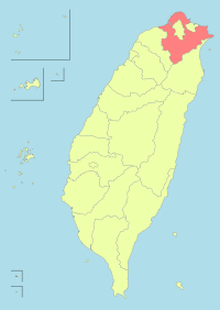
Shiding District
| Shiding 石碇區 | |
|---|---|
| District | |
| Shiding District | |
|
| |
 Shiding District in New Taipei City | |
| Coordinates: 025°00′N 121°39′E / 25.000°N 121.650°ECoordinates: 025°00′N 121°39′E / 25.000°N 121.650°E | |
| Country | Republic of China (Taiwan) |
| Special municipality | New Taipei City |
| Population (January 2016) | |
| • Total | 7,857 |
| Time zone | +8 |
Shiding District (Chinese: 石碇區; Hanyu Pinyin: Shídìng Qū; Tongyong Pinyin: Shíhdìng Cyu; literally: "stone anchor") is a rural district in southern New Taipei City, Taiwan.
History
Shiding used to be a thriving town during the Qing Dynasty due to its geographically favorable condition as a resting place on the way to Yilan and its coal mine resources and tea trading. Shiding was a rural township of Taipei County until the upgrade of the county to become the New Taipei municipality on 25 December 2010, Shiding became a district.
Geography
- Area: 144.35 km²
- Population: 7,857 people (January 2016)
Education
Tourist attractions
- Huafan Culture Gallery
- Lumantan Forest Bath
- Putty Painting House
- Shiding Danlan Culture Hall
- Shiding East Street
- Shiding West Street
Transportation
The district is accessible by bus from Jingmei Station of Taipei Metro.[1]
See also
| Wikimedia Commons has media related to Shiding District, New Taipei. |
References
External links
| ||||||||||||||||||||||||||||||||||
| ||||||||||||||||||||||||||||||||||||||||||||||
This article is issued from Wikipedia - version of the Saturday, February 13, 2016. The text is available under the Creative Commons Attribution/Share Alike but additional terms may apply for the media files.

